Diving at Atlantis Reef

The dive site Atlantis Reef or Pillars of Hercules is an offshore rocky reef in the Finlay's Point area of the Castle Rocks Restricted area on the False Bay coast of the Cape Peninsula, near Cape Town in the Western Cape province of South Africa.
Understand[edit]


Atlantis reef is a section of the granite reef of the Castle Rocks restricted zone near Partridge Point, so the marine life has been protected for many years and is flourishing. There is no record that the site has been dived before 2011, so it is in pristine condition. The two massive pinnacles marking the site and known as the Pillars of Hercules, were known to exist for some time, as they occasionally show up on the echo sounder of passing boats, but they are a really small target and difficult to find again. However in early September 2011, the dive boat Animal Ocean started investigating the site and reported an exceptionally beautiful area of reef with two impressive pinnacles reaching nearly to the surface but with very small peaks, so they do not break very often, and are in any case to some extent in the lee of the Seal Rock at Partridge Point. Further exploration revealed that the surrounding reef includes some areas of high profile reef near the pinnacles, and further offshore, and extensive medium and low profile reef further inshore, with scattered large boulders.
Position[edit]
- 1 Pillars of Hercules: S34°15.075' E018°29.027', the nominal position for the site, and the main point of interest.
This site is in the Table Mountain National Park Marine Protected Area since 2004. A permit is required. It is entirely inside the Castle Rocks Restricted Zone, so no fishing of any kind is permitted.
Name[edit]
The site name was chosen by the first divers to report diving at the site. It is named after the legendary lost continent of Atlantis from Greek mythology. The Santorini pinnacles refer to the volcanic Mediterranean island which has been suggested as a possible site for a historical Atlantis.
Depth[edit]
Maximum depth is about 29 m at the eastern limit of the reef, and the top of the highest pinnacle is about 4 m deep. Depth on the immediately adjacent reef is 18 to 24 m.
Visibility[edit]
Visibility can vary like any other dive site in the area, but in diveable conditions is likely to be between 5 and 10 m, and on a very good day, up to 20 m. It is generally similar to, but often not quite as good as visibility on the Smitswinkel Bay wrecks
Topography[edit]
The site is dominated by a pair of massive pinnacles, which rise from a jumbled mass of boulders below 18 m to within 5 m of the surface. The tops of the pinnacles are relatively small and rounded, and are probably in the order of 3 m diameter, but they spread out to 15 to 20 m wide with roughly rectangular plan at 12 to 15 m depth. These have been named the "Pillars of Hercules, in keeping with the Greek mythology theme. On the western and southern sides of the eastern pinnacle there is a large overhang. The granite base between the two pinnacles has a deep crack in it, and to the offshore side of the pinnacles, there is a complex swimthrough formed by jumbled boulders. There is a ledge to the north at about 18 m, and a number of very large boulders in the immediate vicinity to the north. A fairly large rock with a pointed top at about 17 m known as the "Fang" stands a few metres to the east of the pinnacles. It is shaped a bit like a large canine tooth. There is sand a few metres to the south of the pinnacles at about 24 m depth.
To the east of the pinnacles the reef edge comprises medium to large outcrops of granite corestone, with sand between them in the gaps. The reef tends to get lower to the north and more broken to the north west, where large areas are quite low and made up of small boulders and low outcrops.
South east of the pinnacles there is a large outcrop a few metres high which has a dense growth of Sinuous, Flagellar and Palmate gorgonian sea fans.
150 m on a bearing of 145°magnetic from the western pillar, there is another somewhat lower pinnacle, rising to 10 m depth. This and the smaller pinnacle another 30 m to the west have been named the "Santorini pinnacles". They are not as spectacular as the Pillars of Hercules, but are a good dive site in themselves, with plenty of steep walls and overhangs to shelter the reef life.
Geology: Pre-cambrian granite of the Peninsula pluton, with fine quartz sand in the deeper areas and around the reef.
-
 Top of the pinnacle at 4 m depth
 -
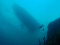 Looking up to the boat from about 12 m deep at one of the pinnacles


Conditions[edit]
The site is often at its best during or after a westerly wind, but may be good even during an easterly if it is not too strong and the swell has not built up yet. Surge may be considerable in long period swell even if low.
The site is exposed to south east wind and waves, and is moderately exposed to south westerly swell, particularly long period swell, which bends round Cape Point, though Atlantis is not far to the north of the reefs at Partridge Point, and they provide some protection from south-westerly swell. The site is usually at its best in winter but there are also occasional opportunities in autumn and spring, and sometimes even in summer a good day may occur.
Look for days when the forecast is for swell from the west, or low swell from the south-west. This can often occur just before a cold front gets to the peninsula, and in these cases the weather is often mild, even sunny, and with little wind in the day or two before the front arrives. During the passage of the front, the weather is generally windy, overcast and frequently rainy, but may still provide very good diving if the wind is not too strong for the boats to operate, as it will be offshore until the front has passed.
After the front has passed, in winter one can expect a day or two of good diving before the next front. In summer, a front is commonly followed by strong south easterly winds, which kick up an unpleasant short onshore chop which makes the boat ride uncomfortable and messes up the visibility.
Get in[edit]
This is a boat access dive site. It is technically possible to dive it from the shore, but there would be a long steep climb down from the road to the shore on a slippery path, followed by a long surface swim. Then you would have to find the site, which in itself is not easy.
The site is about 3.2 km from Miller's Point slipway and 10.4km from Simon's Town jetty.
Do[edit]
Dive at one of the listed drop points and explore the local reef.
1 Pillars of Hercules: S34°15.075' E018°29.027', The main point of interest is a pair of massive pinnacles of similar size and height, standing a few metres apart on a large outcrop at about 21 m depth, extending upwards to about 5 m depth. On the western and southern sides of the eastern pinnacle there is a large overhang. The granite base between the two pinnacles has a deep crack in it, and to the offshore side of the pinnacles, there is a complex swimthrough formed by jumbled boulders. There is a ledge to the north at about 18 m, and a number of very large boulders in the immediate vicinity to the north. A fairly large rock with a pointed top at about 17 m known as the "Fang" stands a few metres to the east of the pinnacles. It is shaped a bit like a large canine tooth. There is sand a few metres to the south of the pinnacles at about 24 m depth.
2 Santorini pinnacles: S34°15.037' E018°28.928', About 150 m on a bearing of 145°magnetic from the western pillar, there is another somewhat lower pinnacle, rising to 10 m depth. This and the smaller pinnacle another 30 m to the west have been named the "Santorini pinnacles". They are not as spectacular as the Pillars of Hercules, but are a good dive site in themselves, with plenty of steep walls and overhangs to shelter the reef life.
See[edit]
Marine life[edit]

The marine life is extensive and varied. At the tops of the pinnacles and extending to about 12 m is a heavy covering of red bait with both knobbly and false plum anemones living in between them. Descending the pinnacles, the more delicate invertebrates take over and the pinnacles' lower sections are densely covered with bryozoans of at least five different species, and a heavy covering of multicoloured seafans. Between the pinnacles is usually found a school of several species of fishes: blacktails, hottentots, fransmadam and zebras. Moderate numbers of bank steenbras have been seen on the western part of the reef. Nudibranchs such as the black, the crowned and gasflames are common on the pinnacles, with the occasional sighting of smaller nudibranchs such as the orange-eyed nudi and the white-edged nudi. Janbruins can often be seen in the cracks between the pinnacles, and there are some very large Roman.
Where the reef at the base of the pinnacles meets the sand to the south, the lower parts of the reef are covered with red-chested sea cucumbers, strawberry anemones and nippled sea fans. North from the pinnacles in the jumbled boulders is a luxuriant seafan forest, consisting of palmate, sinuous and whip seafans. The usual assortment of invertebrates associated with seafans can also be found: topshell snails, hermit crabs and basket stars in abundance. Further north on a lower profile reef section there is more seafan forest which is sometimes overwhelmed by hairy brittlestars to the extent that it resmbles an afghan rug. The sand at about 29m seems to be a shyshark nursery because many small puffadder shysharks can be seen there. Interestingly, the site also features an unusual number of dark shysharks, more usually seen on the Atlantic side of the peninsula.
-
 Juvenile basket star on sinuous seafan
 -
 Strawberry anemones
 -
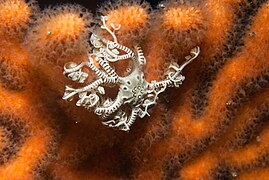
 Gasflame nudibranch
 -
 Lacy false coral is very fragile
 -
 Shoal of Hottentot seabream between the pinnacles
 -
 The tops of the pinnacles are covered with large red bait pods
 -
 The rare bell stalked jellyfish, Lipkea stephensoni


Features[edit]
Notable features of the site, apart from the Pillars of Hercules include the systems of swimthroughs formed by the jumbled boulders at the base of the site and the site's overall topography. Fang-shaped boulders, vertical cracks, embayments of sand, small drop-offs and overhangs are all worth viewing.
Photography[edit]
Good wide angle scenic shots can be taken in conditions of good visibility. The reef life is diverse and prolific, and there are opportunities for both macro photography of benthic organisms, and wide angle photos of the shoals of small fish. The site has been praised as a photographic destination by several notable local underwater photographers, and frequently features on the Facebook site "Underwater Cape Town".
Suggested Routes[edit]
No special routes are known at this stage, but the pinnacles are the highlight of the site, and the dense gorgonian forests on the edge of the reef slightly to the south east of the pinnacles are well worth a visit. The area near the pinnacles appears to be the most topographically interesting, so explore the area, and let us know what you find.
- One route worth trying is to drop in at the south side of the Pillars, descend vertically to 23 m, then to swim east along the reef edge, through a small swimthrough and past the fang-shaped rock to the seafan forest. Since this is relatively deep (around 26 m), depending on your mix, it might be worth while heading back towards the pinnacles either on the northern side, which has many jumbled boulders to explore, or else on the southern side as far as the gap between the pinnacles. Swim through this, past the overhang. Look out for the vertical crack and the janbruin often seen in it, and the resident roman. There are overhangs and swimthroughs to explore and a narrow overhang at about 18 m on the side of the pinnacle which seems to attract many fish. Ascend on the wall of one of the pinnacles — They are shallow enough to do a safety stop on top if there is not too much surge.
- If you like a bit more of a navigational challenge, you can try swimming to the Santorini pinnacles to the north west. Either start at the western Pillar, and swim on a bearing of 325° magnetic for 150 m, or follow the southern reef edge from the Pillars to the west up a sandy gap which goes about 50 m into the reef, then carry straight on (north) another 25 m.
Stay safe[edit]
Hazards[edit]
No special hazards are known.
Skills[edit]
Certification to dive to the depths found at the site would be expected. Parts of the site are within the depth range appropriate for entry level divers, but not very much, and because the site is so pristine, it is recommended that entry level divers and others with imperfect buoyancy control avoid diving there.
Equipment[edit]
No special equipment required. Divers who intend to explore beyond the vicinity of the pinnacles are advised to deploy a DSMB at the end of the dive so the boat can see where they will be ascending.
Nearby[edit]

- 1 Graeme's Spot and The Jambles
- 2 Finlay’s Point
- 3 Finlay's Pinnacle
- 4 Carnaby Street Pinnacle
- 5 Finlay's Deep
- 6 Sherwood Forest
- 7 Partridge Point - Seal Rock
- 8 Partridge Point - Big Rock
- 9 Partridge Point - Peter's Pinnacles
Back to the Alphabetical list of sites, or list of dive sites in the Finlay's Point to Partridge Point area
Other regional dive sites:
- Dive sites of Table Bay and approaches,
- Dive sites of the Cape Peninsula west coast
- Dive sites of False Bay offshore and approaches
- Dive sites of False Bay east coast
- Fresh water dive sites of the Cape Town Metropolitan Area