Diving the ''Brunswick''

The dive site Brunswick is an inshore historical wreck in the Simon's Town area on the False Bay coast of the Cape Peninsula, near Cape Town in the Western Cape province of South Africa.
Understand[edit]


The Brunswick was an English East Indiaman of 1 200 tons, an armed merchant ship of 30 guns that transported goods between Britain and the East Indies. She was captured while homeward-bound on her sixth voyage with a cargo of sandalwood and cotton by Admiral Linois on the French vessel Marengo in 1805, and brought to Simon's Town as a prize of war. It ran aground at Simon's Town on 19 September 1805 after losing three anchors during a south-east gale. The cargo was sold along with the wreck in an auction. Most of the cargo was salvaged, although archaeologists have spotted the odd piece of sandalwood on the wreck site.
The Brunswick was about 40 m long and 13 m wide with three decks, built of wood with iron knees, iron and copper drift bolts, and copper sheathing.
The wreck was officially discovered and identified as the Brunswick in 1993. There is quite a lot of wreckage buried in the sand, which shifts with the seasons and weather to cover and uncover different parts of the wreckage. Steentjies annually uncover areas of the wreck to lay their eggs.
Position[edit]
- 1 Brunswick wreck: S34°10.880’ E018°25.607’
About 120 m offshore, approximately off the north end of the long white apartment block at the bottom of Redhill road.
This site is in the Table Mountain National Park Marine Protected Area since 2004. A permit is required.
Name[edit]
Named for the wreck of the Brunswick at the site.
Depth[edit]
Maximum depth is about 6 m, average about 4.5 m
Visibility[edit]
Visibility is usually moderate, as the area is sheltered from westerlies and to some extent from south easterlies. It is seldom very good, as it is close inshore, but the shallow depth allows good lighting most of the time.
Topography[edit]
The wreck lies in fairly shallow water (about 5 m) The bottom is fine sand. The wood structure of the wreck has become broken up over the years and a large part is buried under the sand. The wreck lies at about 45° to the shoreline. The centreline of the debris field is at about 215° True, from S34°10.859’ E018°25.625’ to S34°10.884’ E018°25.603’, It is about 58 m long, 17 m wide and it extends over an area of about 800 m2
Geology: Sand.
Conditions[edit]
The site can sometimes be dived in easterly winds as long as they are not too strong and the shore break is not too rough. The site is usually dived in winter, when it is frequently fairly calm as it is well sheltered from south west swell.
Facilities[edit]
None.
Get in[edit]
This site can be dived from a boat or the shore.
Shore entry: Parking on main road in front of Long low white block of flats at the bottom of Redhill road. Walk over the railway lines and down the jumble of old concrete sleepers which forms a breakwater. Depending on the tide there may be a narrow sandy beach. It is an easy entry and exit if swell is low. Climbing the breakwater requires some care, but should not be difficult for a fit person. The lower sleepers may be slippery and some will rock when walked on. Be careful.
Boat dive: Be sure not to drop the anchor on the wreck. Anchor just downwind of the wreck to prevent damage. You are allowed to dive on the site, but it is an offense to damage the wreckage or remove any artifact.
See[edit]
Marine life[edit]
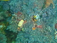
The wreckage is heavily overgrown by kelp and other seaweeds, and a range of invertebrates and fish can be seen.
-
 Crowned nudibranch

Features[edit]
Remains of a historical wooden shipwreck. The wreckage is an archaeological site protected by legislation and may not be disturbed.
The keelson, part of the copper strap attaching the rudder to the boat, a number of iron knees, and one or two pieces of sandalwood are still on the wreck site.
-
 Planking of the Brunswick
 -
 Head of a bronze drift bolt
 -
 Row of drift bolts


Photography[edit]
Wide angle lenses are most likely to produce useful results when photographing the wreckage. The site is shallow, so natural light is usually adequate. For close-up work a flash will restore the natural colour.
Routes[edit]
Swim straight out to the wreck on the surface, Dive and explore the wreck, then swim back to shore on compass bearing 330° magnetic.
Stay safe[edit]
Hazards[edit]
No site specific hazards known.
Skills[edit]
No special skills required. Suitable for night dives, preferably by boat from Long Beach, to avoid the climb over the breakwater.
Equipment[edit]
No special equipment recommended. Reasonably good site for photography. A light is useful to look into crevices.
Nearby[edit]

- 1 P87
- 2 SS Clan Stuart
- 3 HNMS Bato
- 4 Long Beach
- 5 Simon's Town Jetty
- 6 False Bay Yacht Club moorings
- 7 Target Reef
- 8 Ammunition Barges
- 9 Phoenix shoal
- 10 Noah’s Ark Rock
Back to the Alphabetical list of sites, or list of dive sites in the Simon's Town area
Other regional dive sites: