Diving at Klein Tafelberg

The dive site Klein Tafelberg Reef, also known as Salad Bowl, Yacht wreck, and The Patti is an offshore rocky reef in the outer Hout Bay area on the Atlantic seaboard of the Cape Peninsula, near Cape Town in the Western Cape province of South Africa.
Understand[edit]

This can be a spectacular dive in good visibility as the reef profile is very rugged. The depth varies from about 42m to just under 15m over a small area. The reef structure provides a wide range of habitats and there is a large diversity of colourful invertebrates to be seen.
This site is a group of pinnacles at the south eastern end of the large Tafelberg Reef complex, which may extend all the way to Vulcan Rock in the west.
Position[edit]
- 1 Yacht Patti wreck: S34°04.436' E018°19.185'
- 2 Klein Tafelberg pinnacle: S34°04.442' E018°19.191'
- 3 Table Top pinnacle: S34°04.443' E018°19.178'
- 4 42 m sand patch: S34°04.454' E018°19.232'
This site is in the Table Mountain National Park Marine Protected Area since 2004. A permit is required.
Name[edit]
The name "Klein Tafelberg Reef" translates to Small Table Mountain Reef, it is a part of Tafelberg Reef complex and is slightly separate from the main reef, at the south eastern end. The alternative names "Salad Bowl", "Yacht Wreck", and "The Patti" refer to the large variety of colourful reef life on the rocks of the bowl shaped hollow in the side of the reef, and the wreck of the yacht Patti that lies in it.
Depth[edit]
Maximum is about 42 m, and the top of the pinnacle about 14 m. The Table Top pinnacle a short distance to the west is at 15 m and is much larger.
Visibility[edit]
This is an area where visibility is likely to be better than average. On a good day it can exceed 20 m, but 10 m is more likely. Good visibility is often associated with several days of strong south easterly wind which causes upwelling of clear, cold water from the depths. This water is often rich in dissolved nutrients, and if the wind is followed by a few days of bright sunshine, there may be an plankton bloom, also known as a 'red tide' which may decrease the visibility, particularly in the surface layers. However, the deeper water may still be relatively clear, though the light levels will be less and the water will be much greener.


Topography[edit]
The site is a huge granite outcrop with big boulders piled on top, and patches of sand bottom in the deeper areas. This is the eastern section of an underwater hill which stretches from a sand bottom at about 50 m depth, about 100 m south east of the "Table top" pinnacle to near Vulcan Rock and Di's Cracks.
The relief is very rugged and spectacular in good visibility. Although most of the pinnacles are not particularly large, many are very steep and precipitous, with deep cracks and gullies adjacent to them, and there are many places where the reef can be seen towering several metres above you, while there is still a significant drop to the local bottom.
The large flat topped pinnacle at about 15 m depth is known as the Table Top, as it is roughly square and flat on top with sheer sides. This pinnacle is about 21 m long and 17 m wide, and is split by a huge crack about 2 m wide into two unequal sections. The dropoff to the north east is much deeper than to the south west. The pinnacle is two squarish blocks of granite about 6 m high on the edge of a north-east facing cliff of about the same height, The table top is covered by a fairly dense Split-fan kelp forest, and there is an overhang between the bigger pinnacle block and the cliff top.
The wreckage of a small yacht, the Patti, lie on a ledge called the salad bowl at the bottom of the cliff below the Table Top pinnacle, and below the ledge there are a few scattered bits of wreckage on the slope, which continues down to a bit deeper than 36 m, qhere there is a patch of sand.
The view up to the pinnacle from the wreck is quite impressive on a clear day, when the near vertical rock face with the big crack can be clearly seen looming above.
About 80 m to the south east of the pinnacle there is sand at 42 m depth, which extends at least 100 m further to the southeast. This is probably the local bottom of the reef. The slope between this sand and the shallower reef includes a large number of fairly large boulders. To the north of Table Top there is sand at about 36 m.
To the southwest the depth drops to 45 m in places, still quite close to the shallower parts, but beyond an extensive area that is between 20 and 25 m deep and fairly flat from south to southwest of the pinnacle. Much of this flat reef top above 21 m is covered by Laminaria kelp forest.
To the north west of the Table Top there is a stretch of flattish reef about 20 m deep and then a fairly large area of pinnacles rising to above 15 m depth. The north east side of this area includes a long low wall between about 27 m and 21 m.
Geology: Granite of the late Pre-Cambrian Cape Peninsula pluton
Conditions[edit]
The site is exposed to south westerly swells, which can cause a strong surge. Even a low swell can cause a noticeable surge if the period is long. The site is usually at its best in summer but there are also occasional opportunities in autumn and winter. This is a site where some of the world's largest surfable waves can occur, but it is hard to believe this when conditions are suitable for diving.
This is an area which sometimes has upwellings, caused by strong south easterly winds, resulting in cold clear water, which may develop a plankton bloom over a few hours to days, which will reduce the visibility again.
Keep a lookout for times when the south west swell is low and short period, and there is not too much south easterly wind forecast.
There is often a slight surface current, which has been recorded up to 1.4 km/h setting east. This is probably caused by wind, but on calm days the direction will be unpredictable until you are on site. It is not generally considered a hazard, but it would be prudent not to spend too long on the surface before descending as it can carry the diver away from the mark. If ascending away from the shotline, a DSMB will allow the boat to keep track of your drift during the safety stop.
Get in[edit]
The site is only accessible by boat. It is about 4.5 km from Hout Bay Harbour.
See[edit]

Marine life[edit]
Lots of great invertebrates including several species of nudibranch, and various colonial ascidians on the reefs. You will also probably see seals, kelp, and some Hottentot seabream.
The tops of the shallower pinnacles are covered by a dense growth of large red-bait pods, and usually split-fan kelp (Laminaria pallida), with an understorey of smaller red seaweeds, like the Coral plocamium, and supporting a variety of anemones, hydroids and other small invertebrates.
Even near the tops of the pinnacles, corals, false corals and sponges are abundant on the steeper rock faces and particularly under overhangs. Basket stars are frequently seen at this site, sometimes in large numbers, and there are several other starfish, including the brooding cushion star.
-
 Colonial ascidian
 -
 Dreadlocks hydroid
 -
 Noble coral
 -
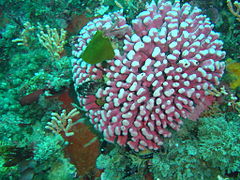
 Reef scene at Klein Tafelberg
 -
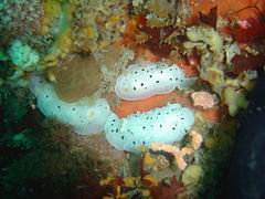
 Silvertip nudibranchs
 -
 Spiky nudibranchs
 -
 Trivia


Features[edit]
Wreck of yacht just north of pinnacle.
One of the most accessible 40 m (42 m if the tide is high) dive sites in the region, with plenty to see on your way up, as it is conveniently only a short distance to the pinnacles, with constantly upward sloping reef along the way.
Photography[edit]
Good site for macro and wide angle photography. Macro will always give you some good subjects, right down to super macro, but wide angle scenic shots will depend on visibility and lighting. You may be lucky.
Routes[edit]
- Descend on the shotline to the reef, swim down to the wreck of the yacht, and continue to the desired depth, then work your way up the rocks to the top of the pinnacle and ascend on the shotline, or deploy your DSMB.
- Descend on the shotline to the sand at 42 m for a deep dive. The shot should be near the reef edge, so after reaching the desired depth, enjoy the rest of the dive by ascending on the reef slope in a generally westerly direction, with a bit of north depending on where the shot was dropped. When you get to about 24 m, swim a contour with the reef to your left until you reach the yacht wreck, then ascend on the Table Top pinnacle to 15 m, deploy your DSMB and surface. If you prefer, you can try to find the smaller but slightly higher pinnacle to the south east of the wreck, but it is only two or three metres higher, and the safety stop will always be in mid-water at this site. This route is shown on the map as the red dotted line for the closest known 42 m area.
- If trying for a 45 m depth to the south of the reef, the swim back along the bottom may be too long to stay within the no decompression limits, as there is a long stretch of flat topped reef about 25 to 20 m deep you will have to cross. More information on this route is needed. Let us know.
Stay safe[edit]
Hazards[edit]
Cold water, Nitrogen narcosis in the deeper areas. Strong offshore winds may develop over a short time. Strong surge if the swell is big and the period is long.
Skills[edit]
No special skills are required, but appropriate certification for the depth is expected. Ability to navigate with a compass and to deploy a DSMB are necessary for the deep dive route.
Equipment[edit]
It is cold and relatively deep, and a dry suit is recommended. This is a dive site where the use of Nitrox can be worthwhile to extend no-stop time. A compass will help keep you orientated, a light will restore colour and allow you to look into crevices and overhangs, and a reel with DSMB is worth carrying in case you need to surface away from the shot line.
Nearby[edit]

- 1 Seal Island
- 2 Di’s Cracks
- 3 Vulcan Rock
- 4 Tafelberg Reef
- 5 Tafelberg Deep
- 6 Tafelberg Deep Pinnacle
Back to the Alphabetical list of sites, or list of dive sites in the Outer Hout Bay area
Other regional dive sites: