Diving at Livingstone Reef

The dive site Livingstone Reef is an offshore rocky reef in the Roman Rock area of Simon's Bay, in False Bay, near Cape Town in the Western Cape Province of South Africa.
Understand[edit]


Fairly high profile corestone reef around the pinnacle, and another large outcrop some way to the east. Quite pretty. Typical medium depth west False Bay invertebrate cover, with lots of sea fans.
Position[edit]
- 1 Livingstone Reef: S34°10.605' E018°27.571'
Bearings:
- 199° magnetic to Roman Rock lighthouse
- 276° magnetic to Long Beach
This site is in a Marine Protected Area (2004). A permit is required. The site is entirely within the Boulders Restricted Zone of the Table Mountain National Park MPA.
Name[edit]
The name "Livingstone Reef" is derived from the name of the diver who found the pinnacle by accident when diving the north pinnacle of Castor Reef. The reef was known to exist, but had not been reported before as a dive site.
Depth[edit]
Maximum depth is about 23 m on the sand and the top of the highest pinnacle is about 14 m. There is another pinnacle to the east which comes up to about 17 m.
Topography[edit]
The western pinnacle is fairly compact, but made up from a group of large rocks clustered together, with crevices, gaps, and a few overhangs. The highest rock extends about a metre above the 15 m depth contour, and the local area is generally above 18 m for several metres around.
The surrounding reef is relatively low, mostly between 21 and 18 m deep, and the sand is between about 22 and 23 m, with little variation in depth around the reef.
The reef is elongated from north-west to south-east. The length is estimated at about 220 m, and width from south west to north east is about 30 m near the pinnacle. The reef slopes down rapidly to sand to the north-east and southwest, while to the south-east and north west the slope is more gradual, with quite a large area of low reef to the south-east. Further to the south-east it gets more rugged again, and extensive outliers in the form of low ridges and boulders lie to the northeast, east, and south of the high reef.
About 100 m to the south-east of the north-west pinnacle group there is another slightly lower monolithic pinnacle reaching up to about 17 m depth from the sand on the north eastern side. Further to the north-east is an area of low boulders, many with sand between them, and seldom more than 1 to 1.5m high off the sand, and a massive outlier directly to the east reaching up to 19 m on top of the main ridge. The area between the northwest and southeast pinnacles is low and broken, with narrow sandy gaps and occasional higher ridges. This area has not been fully surveyed.
Geology: Granite corestones of the Peninsula pluton, surrounded by fairly fine quartz sand, with shelly patches.
Conditions[edit]
The site is exposed to south easterly wind and waves, so should be dived in light winds, or if the wind is somewhat from the west, and is often good in winter. The site is reasonably protected from south westerly swell, but if the wave period is long there may be significant surge. This is an area which sometimes has a thermocline, and the temperature may drop several degrees, often with a marked improvement in visibility, resulting in better but colder conditions than the surface would suggest. Temperatures may drop by more than 5%deg;C across the thermocline, and this is more likely in summer.
Get in[edit]
Boat dive: The site is too far offshore to swim
The site is about 6.1 km from Miller's Point slipway, 3.5 km from False Bay Yacht Club, or 3.3 km from Long Beach
See[edit]
Marine life[edit]
The reef cover is typical for this area and depth range. There are fairly large numbers of gorgonian sea fans, anemones, soft corals, arborescent htdroids, bryozoans, feather stars and sea cucumbers. Fish include Bank steenbras, Redfingers, Two-tone fingerfin, Hottentot, Chubby clingfish, Klipfish and various shy-sharks.
-
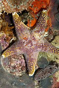 Grey starfish Callopatiria formosa
 -
![A chubby clingfish Apletodon pellegrini on the sand at Livingstone Reef]]](//upload.wikimedia.org/wikipedia/commons/thumb/d/d9/Chubby_clingfish_DSF8969.jpg/269px-Chubby_clingfish_DSF8969.jpg) A chubby clingfish Apletodon pellegrini on the sand at Livingstone Reef]]
A chubby clingfish Apletodon pellegrini on the sand at Livingstone Reef]]

![A chubby clingfish Apletodon pellegrini on the sand at Livingstone Reef]]](/wiki/File:Chubby_clingfish_DSF8969.jpg)
Features[edit]
The pinnacle is an area of complex topography, with several deep gullies and crevices, and a few overhangs and small swim-throughs
Photography[edit]
This is a good site for macro photography, and if the visibility is good, wide angle should produce good results.
Suggested Routes[edit]
The most spectacular area known is in the immediate vicinity of the pinnacle. Dive around it, from the sand to the NE and SW to the top of the pinnacle. If you choose to go further afield, try following the north east edge to the eastern pinnacle, and further.
There may be a fairly large area of unsurveyed reef to the northeast of the western pinnacles. There are no reports yet of what may be there
Stay safe[edit]
Hazards[edit]
No site specific hazards are known.
Skills[edit]
No special skills required, Most of the site is deeper than the recommended limit for most entry level divers. Certification appropriate to the depth is expected. The ability to deploy a DSMB is recommended.
Equipment[edit]
A DSMB is recommended so that the boat can see where you will be surfacing.
Nearby[edit]

- 1 Target Reef
- 2 Castor Rock - Central Pinnacle
- 3 Friskies Pinnacle
- 4 Roman Rock
- 5 Tivoli Pinnacles
- 6 Rambler Rock Southern pinnacles
- 7 Dome Rock
- 8 Noah’s Ark - Twin barges
- 9 Phoenix shoal
Back to the Alphabetical list of sites, or list of dive sites in the Roman Rock area
Other regional dive sites:
- Dive sites of Table Bay and approaches,
- Dive sites of the Cape Peninsula west coast
- Dive sites of False Bay offshore and approaches
- Dive sites of False Bay east coast
- Fresh water dive sites of the Cape Town Metropolitan Area