Diving the MFV ''Princess Elizabeth''

The dive site MFV Princess Elizabeth is a recent wreck in the Smitswinkel Bay area on the Cape Peninsula side of False Bay, near Cape Town in the Western Cape province of South Africa.
Understand[edit]


This is one of the best preserved of the Cape Town wrecks. It is at a depth where a reasonable bottom time is possible, particularly on nitrox, and the position is sheltered from the prevailing swell, so surge is not usually strong. Visibility varies, and may be good for the area. The wreck is small and the whole site may be visited on a single dive excluding penetrations. Various penetrations are possible to the competent and properly equipped diver.
Position[edit]
- S34°16.060’ E018°28.816’ 1 MFV Princess Elizabeth (Bow)
- S34°16.068’ E018°28.839’ 2 MFV Princess Elizabeth (Stern)
The MFV Princess Elizabeth is the central of the five wrecks in Smitswinkel bay.
This site is in a Marine Protected Area (2004). A permit is required.
Name[edit]
The "MFV Princess Elizabeth" was built in 1961 by Cook, Welton and Gemmel Ltd, of Beverly, East Yorkshire. The trawler was badly damaged by a fire and was donated to the False Bay Conservation Society along with the Orotava by Irvin and Johnson. In August 1983 the vessels were towed out to Smitwinkel Bay and were scuttled.
The Princess Elizabeth is the smaller of the two trawlers and lies on the sand at 36 metres with a slight list to starboard. The depth at the top of the wreck is about 28 m.
| Displacement | 735 | tonnes | |
| Length over all | 41 | .8 | m |
| Beam | 8 | .5 | m |
| Draft | 4 | .8 | m |
| Engine power | 1050 | BHp | |
| Crew | 20 |
Depth[edit]
Sand bottom is at about 36 m and the top of the wreck is a bit shallower than 28 m at the top of the wheelhouse.
Visibility[edit]
Visibility is subject to the same conditions as the other Smits wrecks. It varies from a few metres to over 20 m on a very good day. Visibility also may vary with depth, and it is not unusual for a surface layer of poor visibility to overlay much better visibility on the wreck. In such conditions the water at the bottom will usually be relatively clear, but may also be very dark. In these conditions a dive light is particularly useful, though visibility is unlikely to be too poor to see anything without illumination.
Topography[edit]
The wreck of the Princess Elizabeth is more or less upright on a flat sand bottom, listing about 5° to starboard. The gap from the Princess Elizabeth to SAS Good Hope about 10 m directly astern. The vessel has a raised forecastle and quarterdeck with tumble-home on the quarterdeck and a slightly raked bow and moderate flare forward. The stern is rounded, with a conventional rudder and single propeller aperture (no propeller). The superstructure is basically a wheelhouse deck which slightly overhangs the deck below on both sides, and to a lesser extent, forward.
The wreck is in fairly good condition. Hull plating is almost intact, but decks are wasted in places, with a few big holes between frames on the forecastle and on the quarterdeck. Interior under quarterdeck looks accessible from the sides of the main deck.
There is a large winch on the waist deck just forward of wheelhouse, and three hatches with fairly high coamings in line forward of the winch. Forward of this on the port side is a shelter continuous with the forecastle, and a hatch on the centreline smaller than the three closer to the winch. There is also a much smaller hatch offset slightly to port and slightly forward of the other, wider hatches. On the starboard side just behind the forecastle there is a heavy davit which was part of the trawl net handling gear.
The bipod mast has been cut down and is lying on the waist deck with its top just forward of the winch and the topmast over the starboard winch drum. The bases of the mast tubes are still fixed to the deck near the bottom ends of the cut off part. The mast partially obscures the aftmost of the three main hatch openings on the waist deck. The tube forestays are also on the deck.
The funnel appears to be reduced from its original height as it only projects about half a metre above wheelhouse deckhead. Funnel top is about 3 m wide, maybe 4 m long. The deckhead of the forward part of wheelhouse and the forward bulkhead are missing, but the side bulkheads still stand.
There is an anchor winch on the forecastle forward of a wavebreak.
Interior: The forecastle is easily accessed by a clear doorway on the aft bulkhead to the waist deck. Interior of the forecastle fairly tight, due to pillars and cables. There is a hole through to a small forpeak which is open to the deck above and admits light. Just forward of the entry doorway is a hatch through the main deck to a lower compartment. The opening is of moderate size and should be accessible with sidemount. The cargo hold below the waist deck is easily accessible through two large, clear hatches in the deck and illuminated further by smaller hatches. The interior is fairly clear of obstructions and moderately silted. The aft bulkhead has a wide opening to a machinery space which is dark and more heavily silted.
The superstructure extends forward from a short quarterdeck with partially covered walkways on each side. The wheelhouse has lost its desckhead and forward bulkhead, so is very open. and the side plating is also extensively wasted to the extent that one can swim through in places. The stack is directly behind the wheelhouse and you can see into it and the exhaust mufflers and ducting are visible.
The aft accommodation in the superstructure is aceessible through a fair sized doorway on the port side. The interior is even more tight than the forecastle as the passages and compartments are very small. It is well lit by holes in deck and bulkheads. The engine room is easily accessible from the aft accommodation but it is heavily silted, dark, and tight below the top of the engine.
Geology: Flat fine white sand bottom all around the wreck.
Conditions[edit]
The site is exposed to swell from the south east, and to a certain extent, from the south west. Longer period swell will make conditions on the wrecks uncomfortable or hazardous due to strong surge, but short period waves will just make it uncomfortable on the boat. Visibility is less predictable, and at this time is largely a matter of luck and reports from divers who were in the area recently.
The site is usually at its best in winter but there are also occasional opportunities at other times of the year, though least often in summer, when the south east wind tends to blow much of the time.
Get in[edit]
This site is only accessible by boat. It is about 5.2 km from the slipway at Miller's Point and 12.5 km from Simon's Town jetty.
See[edit]
Marine life[edit]
The wreck is too deep for much seaweed, but it is heavily encrusted with invertebrates, some of which are seldom seen anywhere else but the Smits wrecks. Fish seen here include Hottentot, Redfingers, Barred fingerfin, Bank steenbras. Mauve sea cucumbers, red starfish, spiny starfish and basket stars can usually be found. Multicolour sea fans, Cauliflower soft corals and purple soft corals are scattered around the wreck.
-
 Multicoloured sea fans
 -
 Invertebrate aggregation
 -
 Red starfish and whelk
 -
 Frilled nudibranch and mauve sea cucumber
 -
 Redfingers
 -
 Juvenile bank steenbras


Features[edit]
Fairly intact wreck of a steel side trawler. The fishing gear winch is still on deck and easily identifiable, as is the anchor winch.
-
 View from the starboard side looking forward, showing the trawl davit and break of the forecastle
 -
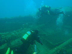 Divers over the waist deck
 -
 The front and most of the deckhead of the wheelhouse is missing
 -
![Fishing winch on the waist deck forward of the wheelhouse]]](//upload.wikimedia.org/wikipedia/commons/thumb/0/06/Fishing_winch_of_the_wreck_of_the_MFV_Princess_Elizabeth_P3167257.JPG/240px-Fishing_winch_of_the_wreck_of_the_MFV_Princess_Elizabeth_P3167257.JPG) Fishing winch on the waist deck forward of the wheelhouse]]
Fishing winch on the waist deck forward of the wheelhouse]] -
 Forecastle deck
 -
 Quarterdeck


![Fishing winch on the waist deck forward of the wheelhouse]]](/wiki/File:Fishing_winch_of_the_wreck_of_the_MFV_Princess_Elizabeth_P3167257.JPG)


Photography[edit]
In good visibility a wide angle or fisheye lens can get good scenic shots, but if you want to use flash, quite powerful strobes will be needed, and well offset to minimise backscatter. There will always be something of interest for the macro photographer.
Routes[edit]
No particular route recommended. Penetrations are tight and limited by the small size of the vessel. The site is small and can be extensively visited on a single dive, but has sufficient interest to visit on several occasions. If you want to see something else, the wreck of the SAS Good Hope is about 10 m aft of the Princess Elizabeth, and can be seen from the stern if visibility is good. It is very easy to find the Good Hope from the Princess Elizabeth, but in poor visibility it may be difficult to find your way back without a marker or guideline to indicate where to leave the Good Hope (starboard side, just aft of the break of quarterdeck). If you have this problem, swim to the stern of the Good Hope and then swim at a 45° angle between back along the starboard side and away to starboard.
Compartments accessible in March 2013:
- Aft part of forecastle is fairly open and clear of snags, tight further forward. Access through large door on break of forecastle.
- Forecastle hold is pretty empty and free of major snags. It is dark and accessible through a moderate sized hatch just inside the forecastle on the main deck. Not much to see.
- Main fish hold under the waist deck is easily accessible through at least three fairly large hatches on the waist deck centreline. The aft hatch is obstructed by the mast which lies on the deck over the hatch. Not much to see and fairly dark.
- Wheelhouse is easily accessible, well illuminated by natural light and accessible through the front, which is completely open.
- Quarterdeck accommodations are tight. Several small compartments with occasional snags. Accessible through doors on the sides and holes on the deck. Lighting depends on the holes, doors, and windows in the area.
- Machinery compartment is accessible through a hatch on the quarterdeck just aft of the funnel, and indirectly through the other quarterdeck compartments. The engine room is central but more accessible on the port side, where it is possible to go down about two decks and still see daylight directly. there are tight spaces leading into darkness fore and aft.
Stay safe[edit]
Hazards[edit]
Scorpion fish have been seen on the wrecks, and are well camouflaged. Their spines carry a dangerous venom. Some of the penetrations in the quarterdeck and engine room area are quite tight, and there are lots of snags and sharp edges of rusty plate.
Skills[edit]
Certification appropriate to the depth is expected. Some level of training or experience in wreck diving is recommended, and penetration should only be attempted by suitably competent divers after reconnaissance and appropriate planning.
Sidemount skills are useful for the tighter penetrations.
Equipment[edit]
Equipment appropriate for the depth should be used. Nitrox is recommended for those competent to use it. A light is strongly recommended, and penetration should not be attempted without the appropriate equipment and planning. If you are not entirely certain what this would be, you are not competent to do the penetration.
Sidemount is useful for the tighter penetrations, Cylinders should be fairly neutral for ease of maneuvering with cylinders unclipped and held forward. Most of the interior is to some degree illuminated by natural light, but many of the openings are too small to get out, so either stay close to the entry or use a guideline.
Nearby[edit]

- 1 SAS Transvaal
- 2 MFV Orotava
- 3 Good Hope Reef
- 4 SAS Good Hope
- 5 MV Rockeater
- 6 Smits Cliff
- 7 Smits Reef
- 8 Batsata Rock
Back to the Alphabetical list of sites, or list of dive sites in the Smitswinkel Bay area
Other regional dive sites: