Diving the MV ''Romelia''

The dive site MV Romelia or Sunset Rocks is an inshore rocky reef with recent wreck in the Llandudno area on the Atlantic seaboard of the Cape Peninsula, near Cape Town in the Western Cape province of South Africa.
Understand[edit]


Position[edit]
- 1 MV Romelia wreck: S34°00.732’ E018°19.811’ — (Inverted bow deck section)
North side of Sunset Rocks, Llandudno.
This site is in the Table Mountain National Park Marine Protected Area since 2004. A permit is required. The site is within the Karbonkelberg restricted zone.
Name[edit]
The tankers MV Romelia and MV Antipolis were under tow by the tug Kiyo Maru no.2 from Greece to scrap merchants in the Far East. On July 28, 1977 during a north westerly gale the tow cable to the Antipolis snagged on the sea bed. In the ensuing confusion the cables broke and the two ships were driven aground by the wind. The Antipolis ran aground at Oudekraal, and the Romelia at Sunset Rocks, Llandudno, where its back was broken by the heavy surf and the ship split in two. Later the bow section sank, leaving the stern mostly above sea level on the rocks. Over the years the stern section has also broken up and is no longer visible.
Depth[edit]
Maximum depth is about 24 m, but mostly quite a bit shallower. The bow area reaches sand bottom at approximately 20 m
Visibility[edit]
The visibility in this area is usually improved after a strong or persistent south easterly wind, which will usually also produce cold water. The visibility is adversely affected by any swell, particularly long period swell, as the surge that this causes picks up the bottom sediment and leaves the water full of particulates which cause the visibility to degrade and lots of backscatter in flash photos. On a good day with flat sea after a southeaster, visibility can be more than 20 m, but this does not usually last very long. 5 to 10 m is more likely, and it can be much worse.
Topography[edit]
Big granite corestone outcrops and boulders. The main line of big surface piercing rocks has lower reef to the north, much of it fairly flat, but with occasional high rocks. It slopes out gradually to about level with the end of the big rocks, then gets deeper fairly fast. Wreckage is concentrated along the line of the surface piercing rocks on the north side, in relatively shallow water (mostly 6 to 10 m), and round the end of the last rock to the west. The wreckage is mostly mangled plate, unrecognisable as to what part of the ship it originated from, with a few odd bits in the deeper area which can be recognised as pipe or catwalk fragments.
There is a chunk of bow deck which has inverted over some boulders just beyond the last exposed rock, with big winches and bollards hanging from it, and several metres of large stud link anchor chain wrapped around a huge boulder. There is also a section of mast slightly to the north.
Geology: Late Pre-Cambrian granite of the Peninsula pluton.
Conditions[edit]
Best in conditions of limited surge, as the wreck is shallow. Generally this means a low and short period south westerly component of swell.
The site is exposed to wind and swell from the south west and north west, but is protected from south easterly wind and waves, so should be dived during or after a period of calm or south easterly wind. The site is usually at its best in summer but there are also occasional opportunities in autumn and early winter.
This is an area which sometimes has upwellings, caused by south easterly winds, resulting in clear cold water rich in nutrients, which after a few days may develop a plankton bloom resulting in poor visibility.
Facilities[edit]
Limited roadside parking is available.
Get in[edit]
This site is dived from boats and from the shore.
Boat dive: The site is about 11.7 km from Hout Bay harbour.
Shore dive: Turn off Victoria drive [M6] into Llandudno road. The road makes a sharp bend to the right, but drive straight on into Fisherman’s Bend, and follow the signs for Sandy Bay. These will take you into Sunset Avenue, which goes down to the bottom of the mountainside. Park near to the vacant plot at the bottom of Sunset Avenue, just beyond the first house to the left on the bottom stretch of road. Entry and exit are at a gully directly opposite the vacant plot. There are alternative entries and exits but this one is said to be usable in most weather conditions you would be likely to dive.
-
 The entry point for the Romelia. The narrow gully is a reasonably convenient access route at most states of the tide, and is fairly easily accessible from the road. Sunset Rocks reef is to the left of the photo.
 -
 An alternative access area at Sunset Rocks, to the south of the gully, may be more convenient if the tide is low. Sunset Rocks reef is off to the left of the photo


See[edit]
Marine life[edit]
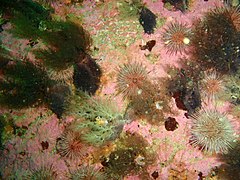
Shallow rocks have the usual red-bait zone, with lots of sandy anemones and striped anemones. There is a band of Black mussels in the intertidal zone round the rocks. The Kelp is largely Ecklonia in the shallower areas, with Laminaria deeper. The wreckage is heavily grown with algae on the top, Deeper flat rocks have large groups of urchins and grey cucumbers. In deeper water there are walls and overhangs with more colourful sponge and coral growth, but not as much as some other sites on this coast.
-
 The exposed flatter deeper areas are usually sparsely populated
 -
 The red bait zone is mostly above 8 m depth
 -
 Reef like is more colourful in sheltered areas
 -
 Three colours of soft corals


Features[edit]
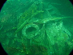
Very broken up wreckage of a large oil tanker. There is a section of the bow deck which has inverted and wedged between some large boulders just offshore of the last exposed rock. This still has some large mooring winches, bollards and fairleads attached, and is an interesting place to visit. Most of the structure of the vessel is so broken up as to be almost unrecognisable, but there is a substantial section of faired mast near the bow wreckage, which may have been a foremast.
-
 The mast section was faired and there is a ladder on the blunt side
 -
 A mooring winch hanging under the inverted section of foredeck
 -
 There is a cavern-like swimthrough under the inverted foredeck
 -
 Much of the wreckage is very broken up


Photography[edit]
If the visibility and lighting is good, there may be opportunities for some fairly spectacular wide angle or fisheye shots, otherwise your best bet is probably macro, but this is not a site with a lot of macro subjects compared to others nearby. You dive here to see the wreck, not the reef.
Routes[edit]
- Shore dive:Swim out on the surface to north of the second big rock, Dive a few metres away from the rock and explore the wreckage as you see fit.
- Boat dive: Drop the shot at the inverted foredeck section, and explore this and the wreckage around the pinnacle in a clockwise direction. Return to the foredeck and ascend up the reef if conditions allow, as there is quite a colourful area near the top where you can do a safety stop and enjoy the view while you wait.
Stay safe[edit]
Hazards[edit]
Cold water, Strong surge in shallow areas. Ragged, sharp edged wreckage. Sea urchins. Strong offshore winds may develop over a short time.
Skills[edit]
No special skills required.
Equipment[edit]
A light is useful for looking into the debris, and a compass will help navigate back to shore at the end of the dive, once out of the influence of the huge mass of steel wreckage.
Nearby[edit]

- 1 Coral Gardens
- 2 13th Apostle
- 3 Logies Bay
- 4 Steps
- 5 MV Harvest Capella
- 6 Rachel's Reef
- 7 Humpback Ridge
- 8 Wilhelm's Wall
- 9 Die Middelmas
- 10 Hakka Reef Sven's Caves pinnacles
- 11 Hakka Reef Southeast pinnacles
- 12 Twin Towers
- 13 MV Keryavor and the Jo May
- 14 SS Maori
- 15 SAS Gelderland
- 16 SS Oakburn / MV Bos 400
Back to the Alphabetical list of sites, or list of dive sites in the Llandudno area
Other regional dive sites: