Diving the MV ''Treasure''

The dive site M.V. Treasure is an offshore recent wreck in the Blaauwberg area on the Atlantic coast near Cape Town in the Western Cape province of South Africa.
Understand[edit]

This is a relatively recent wreck of a huge vessel. The sheer size is awesome. MV Treasure was a 17-year-old Panamanian-registered bulk ore carrier which was transporting 140,000 tonnes of iron ore from China to Brazil when it sank off the coast of South Africa approximately 7 nautical miles north of Robben Island on 23 June 2000 after flooding due to structural damage caused by bad weather. The ship was 264.3 metres long, with a beam of 43.5 metres and draft of 17.4 metres. The ship spilled over 1,300 tons of bunker oil, which contaminated about 20,000 penguins on and around the island. This is considered the worst oil spill in South Africa's history. Sources state it was powered by a single 6 cylinder Sulzer low-speed diesel engine driving a single propeller. Some divers have claimed to have seen two propellers. A wake-equalising duct was fitted ahead of the propeller, which may be the cause of the confusion. The wreck has broken up and subsided considerably in places, leaving a somewhat wider debris field than when it sank, and a few islands of shallower wreckage along the length. The cargo of iron ore pellets is still mostly in the holds, as it is biologically fairly harmless and not worth salvaging.
Position[edit]
- 1 MV Treasure - Bow 32m drop: S33°40.443' E018°19.954'
- 2 MV Treasure - Midships 27m drop: S33°40.372' E018°19.978'
- 3 MV Treasure - Propeller 51m drop: S33°40.312' E018°19.982'
This site is not in a Marine Protected Area (2019). A permit is not required.
Name[edit]
"MV Treasure" was the name of the ship when it sank.
Depth[edit]
Maximum depth is about 51 m, and the top of the deck varies between about 27 and 30 m. The structure has partially collapsed, and most is below 40 m.
Visibility[edit]
The wreck is in an area where visibility is not often good.
Topography[edit]
The vessel lies roughly upright on a fairly level bottom. The superstructure was removed shortly after the sinking by sawing it off with a cable towed by tugs as it was a hazard to shipping. It is not yet known where the superstructure lies in relation to the hull.
The MV Treasure had 9 large hatch openings with mechanised covers on the deck between the superstructure at the stern and the forecastle area in the bows.
The bow section has broken away from the rest of the wreck. This section is about 32 m wide and 25 m long (fore and aft) at deck level, and the bulwarks are still standing round the edges of the deck The bow area had a foremast with a small deckhouse at the base. The mast is gone, but the stub and the deckhouse remain. This is central on the bow deck, and the long dimension of the deckhouse is fore and aft. This means that the stem is directly in line with the long axis of the deckhouse. The deckhouse is narrow (maybe 1.5 m) and about 1 level high, and about 5 or 6 m long at a guess. There are some handrails on top, and the stub of the mast. The aft bulkhead has a large rectangular opening near the top which may have been a ventilator opening. There is an open doorway on the port side aft, and forward of this a hatch in the deck, also to port, and level with the front of the structure. The cover appears to be lying on deck nearby. Directly in front of the deckhouse is a fairly large winch, and to port and starboard are pairs of very large winches. One of these winches on the port side has a structure in front of it which looks like it may include two roller/sheaves and a hole much like a hawse pipe opening, but rectangular. There is no sign of chain on deck, and the winches look more suitable for handling rope, so the anchor handling gear may be below deck. There were indentations on the bulwarks, where the bulwark was stepped back from the edge of the deck, both port and starboard roughly abreast of the front of the deckhouse, but the bow section has broken away from the rest of the wreck just behind the port indentation, and forward of the starboard indentation, so only one is present on the bow section of the wreck. It is not clear what the function of these indentations was. There are several large pairs of bollards on the foredeck, and openings in the bulwarks fitted with what may be roller fairleads.
The bow deck section was continuous with the main deck which had the hatch openings to the holds, but is now broken off. There is another section of wreckage some 30 m to the north-east of the bow section, which is probably part of the hull including some of the main deck and part of a hatch opening The top of this section is at about 25 m depth. The almost level deck of this section has railings along at least one side, which would most likely be the side of the ship. The deck of this section is an L-shaped area about 35 m long and 25 m wide. To the north-east of this there is more wreckage a few metres deeper (about 35 m) and tilted at a greater angle. On this section some huge equipment has been seen, which is thought to be the hatch cover operating machinery, and the hatch opening to a hold.
The wreckage is continuous from bow to stern, but has collapsed in several places and there are small areas that remain at approximately the original level, with intervening sections collapsed to varying degrees and somewhat spread out sideways. The bow section has subsided a few metres and tilted so that the deck inclines quite steeply.
There is a propeller visible at the stern. Reliable sources claim that the ship had a single screw driven by a large diesel engine, but some eyewitness reports say two screws. The screw has a vaned annular duct fitted to the sternpost forward of the propeller to straighten and align the wake flow before it got to the propeller, to improve fuel consumption and reduce cavitation and vbration. This may have been mistaken for a second propeller in bad light. The top blade is bent at the tip. The stern area is said to be fairly intact, with the deck tilted down on the starboard side and the transom face more or less vertical. Because of this tilt, the propeller is only accessible from the port side slightly forward of the transom.
Geology: White sand at the base of the transom.
Conditions[edit]
The site is exposed to wind from all directions, and swells from the north west and south west, so should be dived when the swell is low and preferably short period.
The site should be at it's best in summer but there may be occasional opportunities at any time of the year
This is an area which sometimes has strong offshore winds which can come up quickly, resulting in a very bumpy return trip. Check the weather forecast.
Get in[edit]
Boat dive: Either 26 km from Oceana Power Boat Club slipway or the V&A Waterfront, or 12 km from Melkbosstrand
There are day charter boats which can take a diver to any of the dive sites in the region, but most operators only work from a limited number of launch sites, which limits the dive sites they visit. Visits to a dive site also depend on the weather and are generally not predictable or bookable more than two to four days in advance. See the listing for Cape Peninsula and False Bay boat dive charters and the associated services directory for contact details.
See[edit]
Marine life[edit]
(general description of biota)
Features[edit]
Huge steel structures, with vast openings and massive deck machinery. A large propeller with a wake-equalising duct. Probably also huge machinery in the engine rooms.
-
 Bollard on the foredeck
 -
 Deckhouse end on the foredeck
 -
 Indent on bulwark on the foredeck
 -
 Pair of big winches on the foredeck
 -
 Divers on the wreck of the Treasure, somewhere near amidships.
 -
 Diver at the wreck of the Treasure
 -
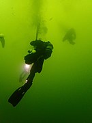 Diver deploying a decompression buoy while ascending from the wreck


Photography[edit]
Almost everything is big, and the lighting and visibility are often not very good, so wide angle to fisheye with natural lighting is likely to get some interesting shots if the conditions are not too bad. Macro will work well enough, but the site is not a place to go for biodiversity, almost anywhere else will have better macro options. Photos showing interesting feature of the wreck, like the propeller(s) would be appreciated for use in this article.
Routes[edit]
No specific routes have been recommended, and the full extent of the wreckage has not been mapped. Drop a shotline on or near the highest point you can find and start there. Explore the quarterdeck, which may give access to the engine room, or move forward over the midships section with its huge hatch openings to the holds.
Stay safe[edit]
Hazards[edit]
This is a site where it would be possible to inadvertently wander into an overhead environment if visibility is low.
Skills[edit]
Advanced deep diving qualifications are expected. Deeper areas should be dived on normoxic Trimix.
Inadvertently swimming into an overhead environment is a serious hazard on this wreck, as you will drown if you don't find your way out. Make sure you can see natural light at all times, or use a cave reel or a line to a SMB
Equipment[edit]
The dive will probably require decompression, and will be relatively deep. Each diver should carry a DSMB and reel, as the wreck is huge and it may not be possible to surface on the shot line. Some level of redundancy of breathing gas supply should be carried, depending on personal skill and dive plan. It will probably be quite dark due to the depth and not very good visibility, and at least one good light should be carried. The water is usually cold, and a dry suit is recommended.
Nearby[edit]

Back to the Alphabetical list of sites, or list of dive sites in the Robben Island area
Other regional dive sites:
- Dive sites of the Cape Peninsula west coast
- Dive sites of the Cape Peninsula east coast
- Dive sites of False Bay offshore and approaches
- Dive sites of False Bay east coast
- Fresh water dive sites of the Cape Town Metropolitan Area