Diving the ''Thomas T Tucker''

The dive site SS Thomas T Tucker is a shoreline rocky reef with a recent wreck in the Southern Peninsula area on the Atlantic Seaboard of the Cape Peninsula, near Cape Town in the Western Cape province of South Africa.
Understand[edit]

This ship was wrecked high on the rocks, and parts of the wreckage are visible on shore. Most of the wreckage is in fairly shallow water.
Position[edit]
This site is in the Table Mountain National Park Marine Protected Area since 2004. A permit is required.

Name[edit]
The "SS Thomas T. Tucker" (Hull Number 269) was a U.S. liberty ship produced by the Houston Shipbuilding Corporation which ran aground at Olifantsbospunt on November 27, 1942, during heavy fog while on her maiden voyage from New Orleans to Suez, carrying a cargo which included tanks and ammunition.
- Class and type: Cargo ship
- Displacement: 14,245 long tons
- Length: 135 m
- Beam: 17.3 m
- Draft: 8.5 m
- Propulsion: Two oil-fired boilers, triple-expansion steam engine, single screw, 2,500 horsepower (1,864 kW)
- Speed: 11 to 11.5 knots
- Range: 23,000 miles
- Capacity: 10,856 metric tons deadweight (DWT)
- Complement: 41 men
- Armament: Stern-mounted 4-in deck gun for use against surfaced submarines, variety of anti-aircraft guns
Depth[edit]
The wreckage is in shallow water. Maximum depth is probably less than 10 m.
Visibility[edit]
Visibility is not often good, as the wreckage is in what is usually the surf zone, and only really divable when the sea is quite flat. However this means that even when the water is fairly dirty, there is still adequate light. Don't expect visibility of more than 5 or 6 metres, and it could be less.
Topography[edit]
Sandstone reef, fairly flat with narrow jointing crevices, no sand, but quite a bit of gravel in crevices, some gravel quite dark in colour. Wreckage extends beyond the high water mark, so is easy to find.
Geology: The reef is Ordovician sandstone of the Peninsula formation. Strike os probably east-west, Dip nearly flat, south.
Conditions[edit]
The site is very exposed to wind and sea from the north west to south west, so should be dived only in exceptionally flat seas. The site is protected from south easterly seas, though it will catch the wind, but if a westerly swell picks up you will have to leave before it gets too rough.
The site is most likely to be diveable in late spring and summer but there may be occasional opportunities at other times.
Get in[edit]
The site is only accessible by boat, as there are no roads providing reasonable shore access. It is 11.2 km from the slipway at the old crayfish factory north of Scarborough, about 17.1 km from the launch site at Kommetjie and 27.5 km from Hout Bay harbour slipway.
See[edit]
Marine life[edit]
Big ecklonia forests, lots of small red and brown saweeds and heavy coralline encrustation on wreckage. Sheltered areas under wreckage have more variety
-
 Coralline and other algae on the reef
 -
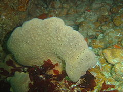 Sponge at the wreck site
 -
 Reef life at the Thomas T Tucker


Features[edit]
Fragmentary wreckage of a steel steamer.
Photography[edit]
Don't take a big expensive camera to this site, particularly if it has external strobes, unless the sea is extremely flat. A small pocket camera will be easier to protect in the surge, and easier to hold still to frame a shot.
Suggested Routes[edit]
No particular routes recommended.
Stay safe[edit]
Hazards[edit]
Strong surge.
Skills[edit]
No special skills required.
Equipment[edit]
No special equipment recommended
Nearby[edit]

Back to the Alphabetical list of sites, or list of dive sites in the Atlantic South Peninsula area
Other regional dive sites:
- Dive sites of Table Bay and approaches
- Dive sites of the Cape Peninsula east coast
- Dive sites of False Bay offshore and approaches
- Dive sites of False Bay east coast
- Fresh water dive sites of the Cape Town Metropolitan Area