File:1700 block of Q Street, NW.jpg
Jump to navigation
Jump to search

Size of this preview: 789 × 599 pixels. Other resolutions: 316 × 240 pixels | 632 × 480 pixels | 1,011 × 768 pixels | 1,280 × 973 pixels | 2,560 × 1,945 pixels | 2,885 × 2,192 pixels.
Original file (2,885 × 2,192 pixels, file size: 1.45 MB, MIME type: image/jpeg)
This is a file from the Wikimedia Commons and may be used by other projects. Information from its description page there is shown below.
Commons is a freely licensed media file repository. |
| Description |
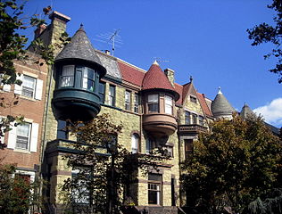
English: Row houses located on the 1700 block of Q Street, NW in the Dupont Circle neighborhood of Washington, D.C. Designed and constructed by Thomas Franklin Schneider in 1889-1892, the houses are considered some of Washington's best examples of Richardsonian Romanesque architecture. The buildings are contributing properties to the Dupont Circle Historic District. |
||
| Date | |||
| Source | Own work | ||
| Author | AgnosticPreachersKid | ||
| Permission (Reusing this file) |
I, the copyright holder of this work, hereby publish it under the following licenses: This file is licensed under the Creative Commons Attribution-Share Alike 3.0 Unported license.
You may select the license of your choice. |

| Camera location | | View this and other nearby images on: OpenStreetMap |
|---|
File history
Click on a date/time to view the file as it appeared at that time.
| Date/Time | Thumbnail | Dimensions | User | Comment | |
|---|---|---|---|---|---|
| current | 13:06, 8 March 2009 | | 2,885 × 2,192 (1.45 MB) | APK | {{Information |Description={{en|1=Row houses located on the 1700 block of Q Street, NW in the Dupont Circle neighborhood of Washington, D.C. Designed and constructed by Thomas Franklin Schneider in 1889-1892, the houses are considered some of Washington's |
File usage
The following page uses this file:
Global file usage
The following other wikis use this file:
- Usage on en.wikipedia.org
- Usage on fr.wikipedia.org
- Usage on www.wikidata.org