File:Aegina general map-en.svg
Jump to navigation
Jump to search

Size of this PNG preview of this SVG file: 640 × 600 pixels. Other resolutions: 256 × 240 pixels | 819 × 768 pixels | 1,092 × 1,024 pixels | 2,185 × 2,048 pixels | 1,200 × 1,125 pixels.
Original file (SVG file, nominally 1,200 × 1,125 pixels, file size: 933 KB)
This is a file from the Wikimedia Commons and may be used by other projects. Information from its description page there is shown below.
Commons is a freely licensed media file repository. |
| Description | |
| Date | (UTC) |
| Source | |
| Author |
|
| This is a retouched picture, which means that it has been digitally altered from its original version. Modifications: english translation. The original can be viewed here: Aegina general map-de.svg:
|
I, the copyright holder of this work, hereby publish it under the following licenses:
This file is licensed under the Creative Commons Attribution-Share Alike 3.0 Unported license.
- You are free:
- to share – to copy, distribute and transmit the work
- to remix – to adapt the work
- Under the following conditions:
- attribution – You must give appropriate credit, provide a link to the license, and indicate if changes were made. You may do so in any reasonable manner, but not in any way that suggests the licensor endorses you or your use.
- share alike – If you remix, transform, or build upon the material, you must distribute your contributions under the same or compatible license as the original.

|
Permission is granted to copy, distribute and/or modify this document under the terms of the GNU Free Documentation License, Version 1.2 or any later version published by the Free Software Foundation; with no Invariant Sections, no Front-Cover Texts, and no Back-Cover Texts. A copy of the license is included in the section entitled GNU Free Documentation License. |
You may select the license of your choice.
Original upload log
This image is a derivative work of the following images:
- File:Aegina_general_map-de.svg licensed with Cc-by-sa-3.0, GFDL
- 2010-07-27T11:02:34Z Uwe Dedering 1200x1125 (956009 Bytes) correct encoding
- 2010-07-26T18:58:00Z Uwe Dedering 1200x1125 (956012 Bytes) -----------------------------
- 2010-07-26T18:11:36Z Uwe Dedering 1200x1125 (955999 Bytes) now with relief grrrrrrrrr
- 2010-07-26T18:07:33Z Uwe Dedering 1200x1125 (131157 Bytes) now stretched 125%
- 2010-07-26T12:46:29Z Uwe Dedering 1200x981 (897246 Bytes) no pattern, but cut out rectangles...
- 2010-07-26T11:44:25Z Uwe Dedering 1200x981 (872280 Bytes) Reverted to version as of 20:12, 23 July 2010
- 2010-07-26T11:37:07Z Uwe Dedering 1200x981 (865412 Bytes) another try
- 2010-07-26T11:32:56Z Uwe Dedering 1200x981 (865422 Bytes) different fill opacity
- 2010-07-26T11:25:55Z Uwe Dedering 1200x981 (872678 Bytes) pattern not 50% but 33%
- 2010-07-26T11:19:59Z Uwe Dedering 1200x981 (871580 Bytes) different pattern, text better readable
- 2010-07-23T20:12:11Z Uwe Dedering 1200x981 (872280 Bytes) pattern 3rd try
- 2010-07-23T20:08:38Z Uwe Dedering 1200x981 (872256 Bytes) pattern 2nd try
- 2010-07-23T19:55:00Z Uwe Dedering 1200x981 (872128 Bytes) pattern try
- 2010-07-23T19:43:23Z Uwe Dedering 1200x981 (872107 Bytes) pistazien
- 2010-07-23T10:29:54Z Uwe Dedering 1200x981 (849957 Bytes) stuff
- 2010-07-23T08:07:33Z Uwe Dedering 1200x981 (844509 Bytes) cities, legend
- 2010-07-21T10:04:15Z Uwe Dedering 1200x981 (831501 Bytes) still work in progress
- 2010-07-17T19:50:48Z Uwe Dedering 1138x896 (321685 Bytes) {{Information |Description={{en|1=General map of Aegina, Greece}} |Source={{own}} |Author=[[User:Uwe Dedering|Uwe Dedering]] |Date=20100710 |Permission= |other_versions= }} Testversion not ready for use in WP [[Category:Maps
Uploaded with derivativeFX
File history
Click on a date/time to view the file as it appeared at that time.
| Date/Time | Thumbnail | Dimensions | User | Comment | |
|---|---|---|---|---|---|
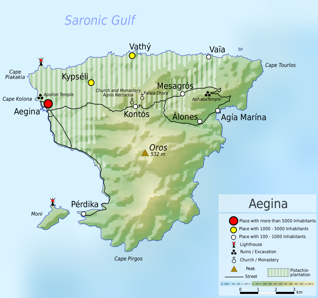
| current | 11:08, 27 July 2010 | | 1,200 × 1,125 (933 KB) | Uwe Dedering | {{Information |Description={{en|1= Map of the island Aegina, Greece. Equirectangular projection. Strechted by 125.0%. Geographic limits of the map: * N: 37.8° N * S: 37.65° N * W: 23.4° E * E: 23.6° E Relief: [http://www2.jpl.nasa.gov/srtm/index.ht |
File usage
There are no pages that use this file.
Global file usage
The following other wikis use this file:
- Usage on da.wikipedia.org
- Usage on de.wikipedia.org
- Usage on hu.wikipedia.org
- Usage on hyw.wikipedia.org
- Usage on ja.wikipedia.org
- Usage on nl.wikipedia.org
- Usage on no.wikipedia.org
- Usage on pl.wikipedia.org
- Usage on sv.wikipedia.org