File:Akita Prefecture cities and towns.svg
Jump to navigation
Jump to search

Size of this PNG preview of this SVG file: 384 × 599 pixels. Other resolutions: 154 × 240 pixels | 308 × 480 pixels | 492 × 768 pixels | 656 × 1,024 pixels | 1,313 × 2,048 pixels | 500 × 780 pixels.
Original file (SVG file, nominally 500 × 780 pixels, file size: 13 KB)
This is a file from the Wikimedia Commons and may be used by other projects. Information from its description page there is shown below.
Commons is a freely licensed media file repository. |
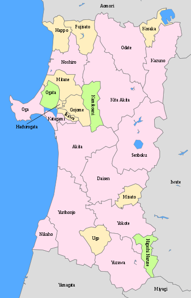
| Description | Map of Akita Prefecture, Japan. Cities, towns, and villages labeled in English. |
| Date | 18:01, 22 April 2008 (UTC) |
| Source | Japanese wiki [1] |
| Author | ja: 利用者:Lincun |
| Permission (Reusing this file) |
GNU Free Documentation License |
![[1]](https://ja.wikipedia.org/wiki/%E7%94%BB%E5%83%8F:%E5%8C%85%E6%8B%AC%E8%87%AA%E6%B2%BB%E4%BD%93%E5%8C%BA%E7%94%BB%E5%9B%B3_05000.svg)
| This is a retouched picture, which means that it has been digitally altered from its original version. Modifications: Added names of cities, villages, and towns, removed scale, changed colors, cleaned up svg. The original can be viewed here: Map of Akita Prefecture, Japan Ja.svg:
|
I, the copyright holder of this work, hereby publish it under the following licenses:
| This file is licensed under the Creative Commons Attribution-Share Alike 3.0 Unported license. | ||
| ||
| This licensing tag was added to this file as part of the GFDL licensing update. |

|
Permission is granted to copy, distribute and/or modify this document under the terms of the GNU Free Documentation License, Version 1.2 or any later version published by the Free Software Foundation; with no Invariant Sections, no Front-Cover Texts, and no Back-Cover Texts. A copy of the license is included in the section entitled GNU Free Documentation License. |
You may select the license of your choice.
Original upload log
This image is a derivative work of the following images:
- File:Map_of_Akita_Prefecture,_Japan_Ja.svg licensed with Cc-by-sa-3.0-migrated, GFDL
- 2008-04-22T18:01:42Z Krisgrotius 500x852 (12762 Bytes) |Description= Map of Akita Prefecture, Japan. |Source= Japanese wiki [http://ja.wikipedia.org/wiki/%E7%94%BB%E5%83%8F:%E5%8C%85%E6%8B%AC%E8%87%AA%E6%B2%BB%E4%BD%93%E5%8C%BA%E7%94%BB%E5%9B%B3_05000.svg] |Date=~~~~~ |Author=
Uploaded with derivativeFX
File history
Click on a date/time to view the file as it appeared at that time.
| Date/Time | Thumbnail | Dimensions | User | Comment | |
|---|---|---|---|---|---|
| current | 00:33, 10 August 2010 | | 500 × 780 (13 KB) | Douglaspperkins | {{Information |Description=|Description= Map of Akita Prefecture, Japan. Cities, towns, and villages labeled in English. |Source= Japanese wiki [http://ja.wikipedia.org/wiki/%E7%94%BB%E5%83%8F:%E5%8C%85%E6%8B%AC%E8%87%AA%E6%B2%BB%E4%BD%93%E5%8C%BA%E7%94 |
File usage
There are no pages that use this file.
Global file usage
The following other wikis use this file:
- Usage on es.wikivoyage.org
- Usage on eu.wikipedia.org
- Usage on id.wikipedia.org
- Usage on ilo.wikipedia.org
- Usage on pl.wikipedia.org
- Usage on pt.wikipedia.org