File:Ancient Roman market place and Serapis temple panorama - Pozzuoli - Campania - Italy - July 11th 2013.jpg

Original file (15,372 × 6,103 pixels, file size: 67.36 MB, MIME type: image/jpeg)
This is a file from the Wikimedia Commons and may be used by other projects. Information from its description page there is shown below.
Commons is a freely licensed media file repository. |
Summary
| Warning | The original file is very high-resolution. It might not load properly or could cause your browser to freeze when opened at full size. |
|---|
| Description |
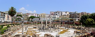
Deutsch: Römischer Marktplatz und "Serapis-Tempel", Pozzuoli nahe Neapel, Kampanien, Italien. English: Ancient Roman market place (Macellum) and so-called Serapis temple, Pozzuoli, Campania, Italy.
Stiching of five photos. |
| Date | |
| Source | Own work |
| Author | Norbert Nagel |
| Camera location | | View this and other nearby images on: OpenStreetMap |
|---|
|
Licensing
- You are free:
- to share – to copy, distribute and transmit the work
- to remix – to adapt the work
- Under the following conditions:
- attribution – You must give appropriate credit, provide a link to the license, and indicate if changes were made. You may do so in any reasonable manner, but not in any way that suggests the licensor endorses you or your use.
- share alike – If you remix, transform, or build upon the material, you must distribute your contributions under the same or compatible license as the original.
|
The author of this file, Norbert Nagel, published this file under the licence CC-BY-SA-3.0 on Wikimedia Commons. This means that free, commercial usage is permitted under the following terms and conditions:
These conditions also apply for any further use of the respective print and online publication. Please send me a specimen copy or the URL of the website where the file is used. Feel free to contact me via e-mail for any questions or in case you need...
Violations of the above terms and conditions will be prosecuted. |
|
Der Urheber Norbert Nagel hat diese Datei unter der Lizenz CC-BY-SA-3.0 auf Wikimedia Commons veröffentlicht. Dies bedeutet, dass eine kostenlose, auch kommerzielle Nutzung möglich ist, wenn die folgenden Bedingungen eingehalten werden:
Diese Bedingungen gelten auch für jegliche Weiterverwendung des jeweiligen Druck- und Onlinepublikation. Bitte senden Sie mir ein Belegexemplar bzw. die URL Ihrer Publikation zu, in der Sie meine Arbeit verwenden. Bei allen Fragen zu diesem Bild und seine Lizenzbedingungen und für die Zusendung der Belegexemplare stehe ich Ihnen gerne per E-Mail zur Verfügung. Bitte melden sie sich auch, falls Sie das Bild...
Verstöße gegen diese Lizenzbedingungen werden verfolgt. |
| Annotations | This image is annotated: View the annotations at Commons |
File history
Click on a date/time to view the file as it appeared at that time.
| Date/Time | Thumbnail | Dimensions | User | Comment | |
|---|---|---|---|---|---|
| current | 14:59, 12 October 2013 | 15,372 × 6,103 (67.36 MB) | NorbertNagel | User created page with UploadWizard |
File usage
The following page uses this file:
Global file usage
The following other wikis use this file:
- Usage on de.wikipedia.org
- Usage on en.wikipedia.org
- Usage on es.wikipedia.org
- Usage on hr.wikipedia.org
- Usage on it.wikipedia.org
- Usage on sl.wikipedia.org