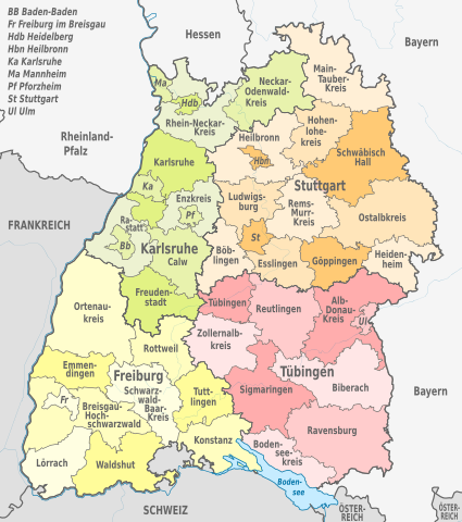
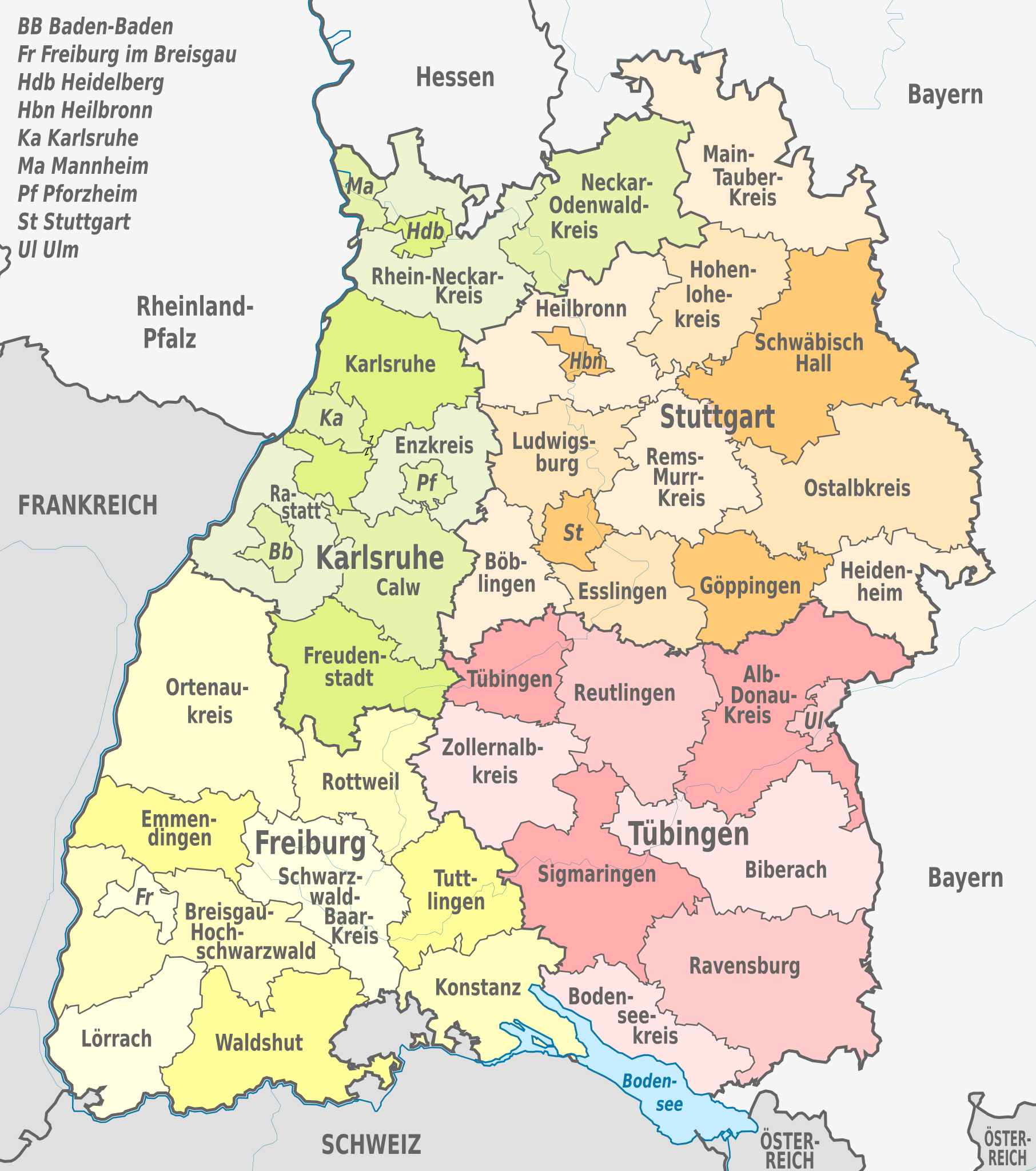
File:Baden-Württemberg, administrative divisions - de - colored.svg
Jump to navigation
Jump to search

Size of this PNG preview of this SVG file: 530 × 599 pixels. Other resolutions: 212 × 240 pixels | 425 × 480 pixels | 679 × 768 pixels | 906 × 1,024 pixels | 1,812 × 2,048 pixels | 1,075 × 1,215 pixels.
Original file (SVG file, nominally 1,075 × 1,215 pixels, file size: 999 KB)
This is a file from the Wikimedia Commons and may be used by other projects. Information from its description page there is shown below.
Commons is a freely licensed media file repository. |
Summary


.svg)


_(Paris_zoom).svg)
.svg)
,_administrative_divisions_-_de_-_colored_(multizoom).svg)
_-_colored.svg)
.svg)
,_administrative_divisions_-_Nmbrs_(multizoom).svg)
,_administrative_divisions_-_de_-_colored.svg)
_-_de_-_colored.svg)

.svg)

.svg)
Licensing
I, the copyright holder of this work, hereby publish it under the following licenses:
This file is licensed under the Creative Commons Attribution-Share Alike 3.0 Unported license.
- You are free:
- to share – to copy, distribute and transmit the work
- to remix – to adapt the work
- Under the following conditions:
- attribution – You must give appropriate credit, provide a link to the license, and indicate if changes were made. You may do so in any reasonable manner, but not in any way that suggests the licensor endorses you or your use.
- share alike – If you remix, transform, or build upon the material, you must distribute your contributions under the same or compatible license as the original.

|
Permission is granted to copy, distribute and/or modify this document under the terms of the GNU Free Documentation License, Version 1.2 or any later version published by the Free Software Foundation; with no Invariant Sections, no Front-Cover Texts, and no Back-Cover Texts. A copy of the license is included in the section entitled GNU Free Documentation License. |
You may select the license of your choice.

|
I'd greatly appreciate, that you attribute this media file to Wikimedia Commons, if used outside Wikipedia or Commons. For use in publications such as books, newspapers, blogs, websites, please insert here the following line:
|
File history
Click on a date/time to view the file as it appeared at that time.
| Date/Time | Thumbnail | Dimensions | User | Comment | |
|---|---|---|---|---|---|
| current | 23:37, 1 January 2013 | | 1,075 × 1,215 (999 KB) | TUBS | |
| 12:26, 2 September 2012 |  | 1,075 × 1,215 (977 KB) | TUBS | == {{int:filedesc}} == {{Information |Description={{de|Karte der politischen Gliederung von XY (siehe Dateiname)}} {{en|Map of administrative divisions of XY (see filename)}} |Source={{own}}{{Adobe Illustrator}}{{Commonist}}{{AttribSVG|Baden-Wuerttemb... |
File usage
There are no pages that use this file.
Global file usage
The following other wikis use this file:
- Usage on als.wikipedia.org
- Usage on da.wikipedia.org
- Usage on de.wikipedia.org
- Baden-Württemberg
- Liste der Wappen in Baden-Württemberg
- Liste der Land- und Stadtkreise in Baden-Württemberg
- Vorlage:Imagemap Baden-Württemberg1
- Liste der Kulturdenkmale in Baden-Württemberg
- Wikipedia:Wiki Loves Earth/DE/Listen/BW/Baden-Württemberg
- Vorlage:Imagemap Baden-Württemberg verlinkbar
- Liste öffentlicher Bücherschränke in Baden-Württemberg
- Liste der Naturdenkmale in Baden-Württemberg
- Liste öffentlicher Kneipp-Anlagen in Baden-Württemberg
- Liste der Wasserschutzgebiete in Baden-Württemberg
- Liste der Geotope in Baden-Württemberg
- Benutzer:Triplec85/Topographische Karte von Baden-Württemberg 1:25000
- Liste von Sakralbauten in Baden-Württemberg
- Liste der Denkmäler des Deutsch-Französischen Krieges in Baden-Württemberg
- Liste der Gemarkungen in Baden-Württemberg
- Liste von Bergwerken in Baden-Württemberg
- Liste aktiver Brauereien in Baden-Württemberg
- Usage on es.wikipedia.org
- Usage on fi.wikipedia.org
- Usage on frr.wikipedia.org
- Usage on fr.wikipedia.org
- Usage on hu.wiktionary.org
- Usage on la.wikipedia.org
- Usage on stq.wikipedia.org
- Usage on www.wikidata.org