File:Brewers Bay.jpg
Jump to navigation
Jump to search

Size of this preview: 800 × 264 pixels. Other resolutions: 320 × 106 pixels | 640 × 211 pixels | 1,024 × 338 pixels | 1,280 × 423 pixels | 6,028 × 1,991 pixels.
Original file (6,028 × 1,991 pixels, file size: 2.32 MB, MIME type: image/jpeg)
This is a file from the Wikimedia Commons and may be used by other projects. Information from its description page there is shown below.
Commons is a freely licensed media file repository. |
Summary
| Description |
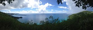
English: Estate Brewers Bay, 2 miles (3.2 km) west of Charlotte Amalie at Brewers Bay Charlotte Amalie Comment on NRHP ref 78002727 - where's the estate, is there a building? Nice photo in any case! |
| Date | |
| Source | Own work |
| Author | Kberg115 |
| Camera location | | View this and other nearby images on: OpenStreetMap |
|---|
Licensing
I, the copyright holder of this work, hereby publish it under the following license:
This file is licensed under the Creative Commons Attribution-Share Alike 3.0 Unported license.
- You are free:
- to share – to copy, distribute and transmit the work
- to remix – to adapt the work
- Under the following conditions:
- attribution – You must give appropriate credit, provide a link to the license, and indicate if changes were made. You may do so in any reasonable manner, but not in any way that suggests the licensor endorses you or your use.
- share alike – If you remix, transform, or build upon the material, you must distribute your contributions under the same or compatible license as the original.

|
This image was uploaded as part of Wiki Loves Monuments 2013.
|
 |
File history
Click on a date/time to view the file as it appeared at that time.
| Date/Time | Thumbnail | Dimensions | User | Comment | |
|---|---|---|---|---|---|
| current | 18:47, 8 September 2013 | 6,028 × 1,991 (2.32 MB) | Kberg115 | User created page with UploadWizard |
File usage
The following page uses this file:
Global file usage
The following other wikis use this file:
- Usage on ceb.wikipedia.org
- Usage on www.wikidata.org