File:Brooklyn neighborhoods map.png
Jump to navigation
Jump to search
Size of this preview: 555 × 600 pixels. Other resolutions: 222 × 240 pixels | 444 × 480 pixels | 710 × 768 pixels | 947 × 1,024 pixels | 2,000 × 2,162 pixels.
Original file (2,000 × 2,162 pixels, file size: 3.27 MB, MIME type: image/png)
This is a file from the Wikimedia Commons and may be used by other projects. Information from its description page there is shown below.
Commons is a freely licensed media file repository. |
Summary
| Description |
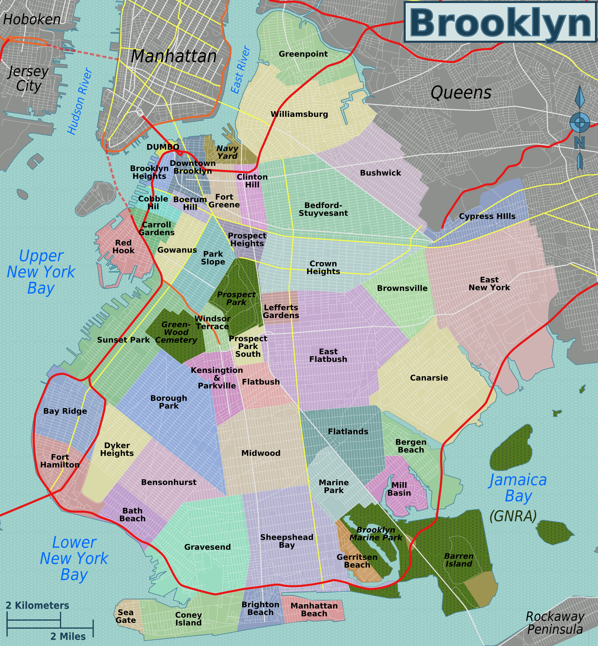
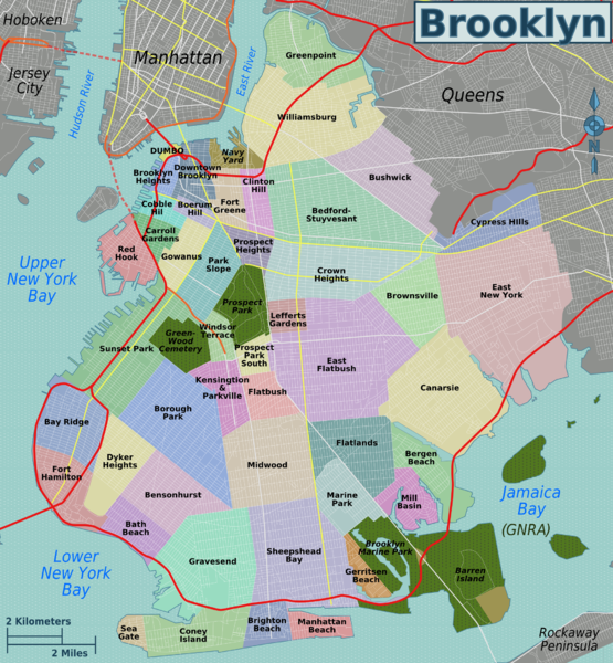
English: Map of Brooklyn's neighborhoods. Exported as PNG from SVG version available for download here |
| Date | |
| Source | Own work by uploader, based on content from OpenStreet Map |
| Author | Peter Fitzgerald |

|
This map image could be re-created using vector graphics as an SVG file. This has several advantages; see Commons:Media for cleanup for more information. If an SVG form of this image is available, please upload it and afterwards replace this template with
{{vector version available|new image name}}.
It is recommended to name the SVG file “Brooklyn neighborhoods map.svg”—then the template Vector version available (or Vva) does not need the new image name parameter. |
Licensing
I, the copyright holder of this work, hereby publish it under the following license:
This file is licensed under the Creative Commons Attribution 3.0 Unported license.
- You are free:
- to share – to copy, distribute and transmit the work
- to remix – to adapt the work
- Under the following conditions:
- attribution – You must give appropriate credit, provide a link to the license, and indicate if changes were made. You may do so in any reasonable manner, but not in any way that suggests the licensor endorses you or your use.
File history
Click on a date/time to view the file as it appeared at that time.
| Date/Time | Thumbnail | Dimensions | User | Comment | |
|---|---|---|---|---|---|
| current | 02:48, 19 July 2009 | | 2,000 × 2,162 (3.27 MB) | Peterfitzgerald | correct a few mistakes |
| 01:27, 19 July 2009 |  | 2,000 × 2,162 (3.26 MB) | Peterfitzgerald | {{Information |Description={{en|1=Map of Brooklyn's neighborhoods. Exported as PNG from SVG version available for download [http://wikitravel.org/shared/Image:Brooklyn_neighborhoods_map.svg here]}} |Source=Own work by uploader, based on content from [http |
File usage
The following 2 pages use this file:
Global file usage
The following other wikis use this file:
- Usage on ar.wikipedia.org
- Usage on arz.wikipedia.org
- Usage on ca.wikipedia.org
- Usage on de.wikipedia.org
- Usage on en.wikipedia.org
- Usage on eo.wikipedia.org
- Usage on es.wikipedia.org
- Usage on fr.wikipedia.org
- Usage on fr.wikivoyage.org
- Usage on hu.wikipedia.org
- Usage on id.wikipedia.org
- Usage on it.wikipedia.org
- Usage on it.wikivoyage.org
- Usage on ja.wikipedia.org
- Usage on nl.wikipedia.org
- Usage on pl.wikipedia.org
- Usage on ru.wikipedia.org
- Usage on www.wikidata.org