File:EdmontonLRT.png
Jump to navigation
Jump to search

Size of this preview: 462 × 599 pixels. Other resolutions: 185 × 240 pixels | 617 × 800 pixels.
Original file (617 × 800 pixels, file size: 71 KB, MIME type: image/png)
This is a file from the Wikimedia Commons and may be used by other projects. Information from its description page there is shown below.
Commons is a freely licensed media file repository. |
Summary
| Description |
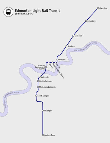
English: Map of the Edmonton Light Rail Transit system, as of April 2010, by Robert McConnell (The Port of Authority). |
| Date | 19 July 2010 (original upload date) |
| Source | en:File:EdmontonLRT.png |
| Author | The Port of Authority at English Wikipedia |
| Camera location | | View this and other nearby images on: OpenStreetMap |
|---|
Licensing
The Port of Authority at English Wikipedia, the copyright holder of this work, hereby publishes it under the following licenses:
This file is licensed under the Creative Commons Attribution-Share Alike 3.0 Unported license.
Attribution: The Port of Authority at English Wikipedia
- You are free:
- to share – to copy, distribute and transmit the work
- to remix – to adapt the work
- Under the following conditions:
- attribution – You must give appropriate credit, provide a link to the license, and indicate if changes were made. You may do so in any reasonable manner, but not in any way that suggests the licensor endorses you or your use.
- share alike – If you remix, transform, or build upon the material, you must distribute your contributions under the same or compatible license as the original.

|
Permission is granted to copy, distribute and/or modify this document under the terms of the GNU Free Documentation License, Version 1.2 or any later version published by the Free Software Foundation; with no Invariant Sections, no Front-Cover Texts, and no Back-Cover Texts. A copy of the license is included in the section entitled GNU Free Documentation License. |
You may select the license of your choice.
Original upload log
- 2009-01-14 19:43 The Port of Authority 552×470 (52 KB) {{Information |Description=Map of the Edmonton Light Rail Transit as of January 2009, by Robert McConnell (The Port of Authority). |Source=self-made |Date=2009-01-14 |Author=~~~ |other_versions= }}
- 2009-07-20 03:05 The Port of Authority 617×761 (75 KB) {{Information |Description = Map of the Edmonton Light Rail Transit, July 2009. Includes extension to South Campus. |Source = I (Robert McConnell -- ~~~) created this work entirely by myself. |Date = 2009.07.19 |Author
- 2009-07-19 00:56 The Port of Authority 617×800 (163 KB) {{Information |Description = Updated map of the Edmonton LRT |Source = I (~~~) created this work entirely by myself. |Date = ~~~~~ |Author = ~~~ |other_versions = }}
- 2010-07-19 01:29 The Port of Authority 617×800 (71 KB) used inkscape this time.
File history
Click on a date/time to view the file as it appeared at that time.
| Date/Time | Thumbnail | Dimensions | User | Comment | |
|---|---|---|---|---|---|
| current | 05:07, 23 November 2012 | | 617 × 800 (71 KB) | OgreBot | (BOT): Reverting to most recent version before archival |
| 05:07, 23 November 2012 |  | 617 × 800 (163 KB) | OgreBot | (BOT): Uploading old version of file from en.wikipedia; originally uploaded on 2010-07-19 00:56:11 by Colipon | |
| 05:06, 23 November 2012 |  | 617 × 761 (75 KB) | OgreBot | (BOT): Uploading old version of file from en.wikipedia; originally uploaded on 2009-07-20 03:05:53 by The Port of Authority | |
| 05:06, 23 November 2012 |  | 552 × 470 (52 KB) | OgreBot | (BOT): Uploading old version of file from en.wikipedia; originally uploaded on 2009-01-14 19:43:12 by The Port of Authority | |
| 03:11, 20 November 2012 |  | 617 × 800 (71 KB) | 117Avenue |
File usage
There are no pages that use this file.
Global file usage
The following other wikis use this file:
- Usage on www.wikidata.org