File:Equatorial Guinea Regions map.png
Jump to navigation
Jump to search

Size of this preview: 483 × 600 pixels. Other resolutions: 193 × 240 pixels | 387 × 480 pixels | 619 × 768 pixels | 825 × 1,024 pixels | 2,000 × 2,483 pixels.
Original file (2,000 × 2,483 pixels, file size: 727 KB, MIME type: image/png)
This is a file from the Wikimedia Commons and may be used by other projects. Information from its description page there is shown below.
Commons is a freely licensed media file repository. |

|
This map image could be re-created using vector graphics as an SVG file. This has several advantages; see Commons:Media for cleanup for more information. If an SVG form of this image is available, please upload it and afterwards replace this template with
{{vector version available|new image name}}.
It is recommended to name the SVG file “Equatorial Guinea Regions map.svg”—then the template Vector version available (or Vva) does not need the new image name parameter. |
Summary
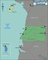
| Description | Map of Equatorial Guinea for use on Wikivoyage, English version |
| Date | |
| Source | Own work based on Perry-Castañeda Library Map Collection Equatorial Guinea Maps |
| Author | Burmesedays |
| Other versions | SVG source |
Licensing
This file is licensed under the Creative Commons Attribution-Share Alike 3.0 Unported license.
- You are free:
- to share – to copy, distribute and transmit the work
- to remix – to adapt the work
- Under the following conditions:
- attribution – You must give appropriate credit, provide a link to the license, and indicate if changes were made. You may do so in any reasonable manner, but not in any way that suggests the licensor endorses you or your use.
- share alike – If you remix, transform, or build upon the material, you must distribute your contributions under the same or compatible license as the original.
Original upload log
| This file was imported from Wikivoyage WTS. |
The original description page was here. All following user names refer to wts.wikivoyage-old.
- 2010-01-23 09:06 (WT-shared) Burmesedays[dead link] 2000×2483 (744456 bytes) {{Imagecredit|credit=[[user:burmesedays]], [http://www.lib.utexas.edu/maps/equatorial_guinea.html Perry-Castañeda Library Map Collection Eq (Import from wikitravel.org/shared)
File history
Click on a date/time to view the file as it appeared at that time.
| Date/Time | Thumbnail | Dimensions | User | Comment | |
|---|---|---|---|---|---|
| current | 23:37, 17 November 2012 | | 2,000 × 2,483 (727 KB) | MGA73bot2 | {{BotMoveToCommons|wts.oldwikivoyage|year={{subst:CURRENTYEAR}}|month={{subst:CURRENTMONTHNAME}}|day={{subst:CURRENTDAY}}}} == {{int:filedesc}} == {{Information |description=Map of Equatorial Guinea. Map of Equatorial Guinea, Equatorial Guinea * Map of... |
File usage
The following 2 pages use this file:
Global file usage
The following other wikis use this file:
- Usage on fr.wikivoyage.org
- Usage on he.wikivoyage.org
- Usage on incubator.wikimedia.org
- Usage on it.wikivoyage.org
- Usage on ja.wikivoyage.org
- Usage on vi.wikivoyage.org
- Usage on zh.wikivoyage.org