File:GrandCaymanMap.png
Jump to navigation
Jump to search
No higher resolution available.
GrandCaymanMap.png (800 × 395 pixels, file size: 47 KB, MIME type: image/png)
This is a file from the Wikimedia Commons and may be used by other projects. Information from its description page there is shown below.
Commons is a freely licensed media file repository. |

|
This file was moved to Wikimedia Commons from wts.oldwikivoyage using a bot script. All source information is still present. It requires review. Additionally, there may be errors in any or all of the information fields; information on this file should not be considered reliable and the file should not be used until it has been reviewed and any needed corrections have been made. Once the review has been completed, this template should be removed. For details about this file, see below. Check now! |
Summary
| Description |
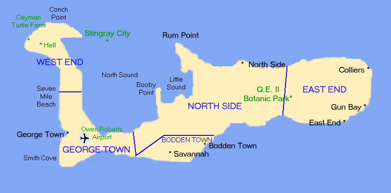
English: Map of Grand Cayman Island, Cayman Islands. Drawn by uploader User:(WT-shared) OldPine, released under CC-by-sa.
|
| Date | 16 August 2006 (original upload date) |
| Source | Own work |
| Author | User: (WT-shared) OldPine at wts wikivoyage |
Licensing
This file is licensed under the Creative Commons Attribution 1.0 Generic license.
- You are free:
- to share – to copy, distribute and transmit the work
- to remix – to adapt the work
- Under the following conditions:
- attribution – You must give appropriate credit, provide a link to the license, and indicate if changes were made. You may do so in any reasonable manner, but not in any way that suggests the licensor endorses you or your use.
Original upload log
| This file was imported from Wikivoyage WTS. |
The original description page was here. All following user names refer to wts.wikivoyage-old.
- 2006-08-16 00:30 (WT-shared) OldPine[dead link] 800×395 (47993 bytes) Map of Grand Cayman Island, Cayman Islands. Drawn by uploader [[User:OldPine]], released under CC-by-sa. (Import from wikitravel.org/shared)
File history
Click on a date/time to view the file as it appeared at that time.
| Date/Time | Thumbnail | Dimensions | User | Comment | |
|---|---|---|---|---|---|
| current | 23:53, 17 November 2012 | | 800 × 395 (47 KB) | MGA73bot2 | {{BotMoveToCommons|wts.oldwikivoyage|year={{subst:CURRENTYEAR}}|month={{subst:CURRENTMONTHNAME}}|day={{subst:CURRENTDAY}}}} == {{int:filedesc}} == {{Information |description=Map of Grand Cayman Island, Cayman Islands. Drawn by uploader [[:wts:User:(WT-... |
File usage
The following page uses this file:
Global file usage
The following other wikis use this file:
- Usage on ar.wikipedia.org
- Usage on en.wikipedia.org
- Usage on es.wikipedia.org
- Usage on id.wikipedia.org
- Usage on pl.wikipedia.org
- Usage on pt.wikivoyage.org