File:Map of Russia - Time Zones (October 2014).svg
Jump to navigation
Jump to search

Size of this PNG preview of this SVG file: 800 × 462 pixels. Other resolutions: 320 × 185 pixels | 640 × 369 pixels | 1,024 × 591 pixels | 1,280 × 738 pixels | 2,560 × 1,477 pixels | 1,092 × 630 pixels.
Original file (SVG file, nominally 1,092 × 630 pixels, file size: 290 KB)
This is a file from the Wikimedia Commons and may be used by other projects. Information from its description page there is shown below.
Commons is a freely licensed media file repository. |
.svg)

|
The boundaries on this map show the de facto situation. This is just one of several different views on the subject (see COM:NPOV). |
Summary
| Description |
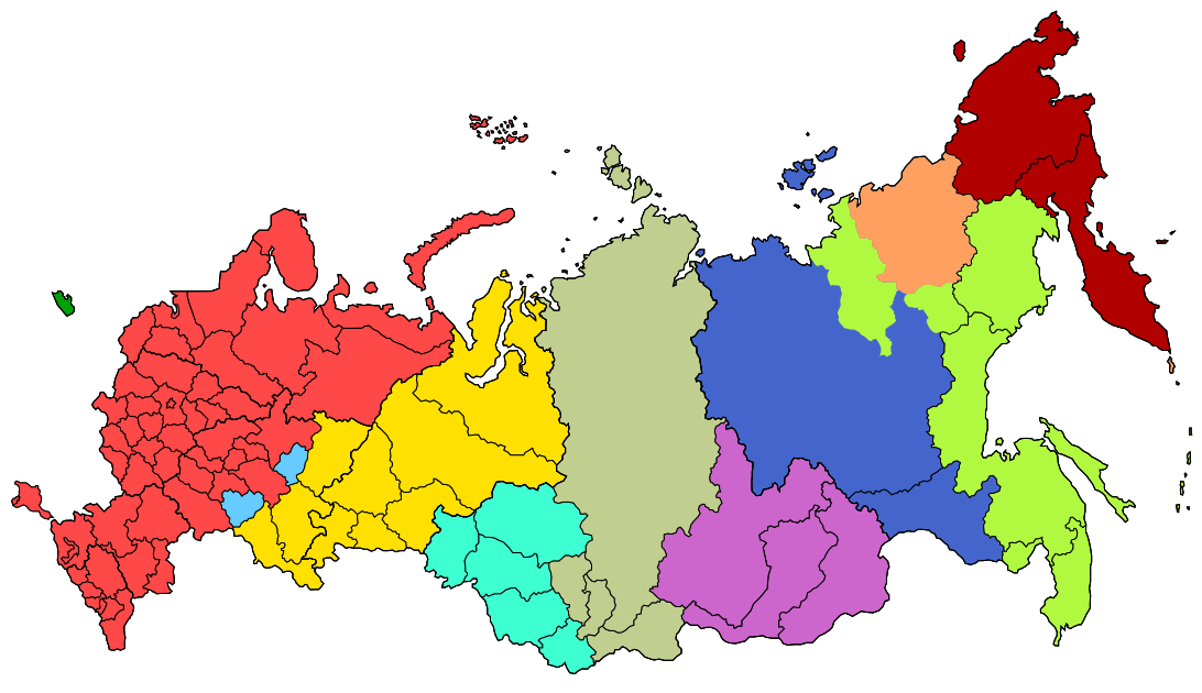
English: UTC+2 (MSK-1), Kaliningrad Time
UTC+3 (MSK), Moscow Time
UTC+4 (MSK+1), Samara Time
UTC+5 (MSK+2), Yekaterinburg Time
UTC+6 (MSK+3), Omsk Time
UTC+7 (MSK+4), Krasnoyarsk Time
UTC+8 (MSK+5), Irkutsk Time
UTC+9 (MSK+6), Yakutsk Time
UTC+10 (MSK+7), Vladivostok Time
UTC+11 (MSK+8), Srednekolymsk Time
UTC+12 (MSK+9), Kamchatka Time |
| Date | |
| Source | File:Map of Russia - Time Zones (September 2011).svg; File:Map of Russia - Time Zones (April 2014).svg |
| Author | Lokal Profil, included Crimea added by Knyaz-1988, reform with October 2014 by PlatonPskov |
.svg)
.svg)
Licensing
This file is licensed under the Creative Commons Attribution-Share Alike 2.5 Generic license.
Attribution: PlatonPskov
- You are free:
- to share – to copy, distribute and transmit the work
- to remix – to adapt the work
- Under the following conditions:
- attribution – You must give appropriate credit, provide a link to the license, and indicate if changes were made. You may do so in any reasonable manner, but not in any way that suggests the licensor endorses you or your use.
- share alike – If you remix, transform, or build upon the material, you must distribute your contributions under the same or compatible license as the original.
File history
Click on a date/time to view the file as it appeared at that time.
.svg&dir=prev)
.svg&offset=20141221233017)
.svg&offset=&limit=20)
.svg&offset=&limit=50)
.svg&offset=&limit=100)
.svg&offset=&limit=250)
.svg&offset=&limit=500)
| Date/Time | Thumbnail | Dimensions | User | Comment | |
|---|---|---|---|---|---|
| current | 01:52, 30 December 2015 | | 1,092 × 630 (290 KB) | PaulGS | Reverted to version as of 18:14, 9 August 2015 (UTC) No consensus to change map |
| 18:26, 29 December 2015 |  | 512 × 295 (197 KB) | Consiglieri88 | Internationally recognised borders. | |
| 18:14, 9 August 2015 |  | 1,092 × 630 (290 KB) | Brateevsky | see File talk:Time zones of Europe.svg. And also: хорош сидеть за компьютером, спасай свою недострану | |
| 16:46, 9 August 2015 |  | 512 × 295 (197 KB) | Vit-ua | New version | |
| 13:47, 8 March 2015 |  | 1,092 × 630 (290 KB) | Knyaz-1988 | Новая версия | |
| 13:29, 8 March 2015 |  | 1,092 × 630 (289 KB) | Knyaz-1988 | Новая версия | |
| 00:05, 8 March 2015 |  | 1,092 × 630 (264 KB) | Knyaz-1988 | Новая версия | |
| 22:51, 15 February 2015 |  | 1,092 × 630 (259 KB) | Leftcry | Minor fix | |
| 22:41, 15 February 2015 |  | 1,092 × 630 (215 KB) | Leftcry | Remove internal borders in Yakutia to not make it seem like separate subjects | |
| 23:30, 21 December 2014 |  | 1,092 × 630 (218 KB) | Lokal Profil | Fixing some paths along Sakha and correcting time zone of kuril islands |
File usage
There are no pages that use this file.
Global file usage
The following other wikis use this file:
- Usage on ar.wikipedia.org
- Usage on ca.wikipedia.org
- Usage on de.wikipedia.org
- Usage on en.wikipedia.org
- Usage on hi.wikipedia.org
- Usage on hu.wikipedia.org
- Usage on ja.wikipedia.org
- Usage on mk.wikipedia.org
- Usage on mr.wikipedia.org
View more global usage of this file.
.svg)
.svg)