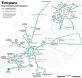
File:Map of the Timișoara tramway and trolleybus routes.png
Jump to navigation
Jump to search

Size of this preview: 724 × 600 pixels. Other resolutions: 290 × 240 pixels | 580 × 480 pixels | 927 × 768 pixels | 1,237 × 1,024 pixels | 2,473 × 2,048 pixels | 3,108 × 2,574 pixels.
Original file (3,108 × 2,574 pixels, file size: 3.91 MB, MIME type: image/png)
File history
Click on a date/time to view the file as it appeared at that time.
| Date/Time | Thumbnail | Dimensions | User | Comment | |
|---|---|---|---|---|---|
| current | 18:44, 18 February 2018 |  | 3,108 × 2,574 (3.91 MB) | Chumwa | kleinere Korrekturen und Ergänzungen |
| 20:56, 8 February 2018 |  | 3,108 × 2,574 (3.89 MB) | Chumwa | Aktualisierung | |
| 07:47, 23 September 2017 |  | 3,108 × 2,574 (3.88 MB) | Chumwa | Aktualisierung und kleinere Korrekturen | |
| 06:00, 15 September 2017 |  | 3,108 × 2,574 (3.88 MB) | Chumwa | Aktualisierung | |
| 19:37, 18 August 2016 |  | 3,108 × 2,574 (3.89 MB) | Chumwa | Wiederinbetriebnahme Linie 13, kleinere Korrekturen | |
| 05:29, 18 June 2016 |  | 3,108 × 2,574 (3.89 MB) | Chumwa | kleinere Korrektur | |
| 21:42, 26 January 2016 |  | 3,108 × 2,574 (3.88 MB) | Chumwa | neuer Hintergrund | |
| 21:27, 25 January 2016 |  | 3,108 × 2,574 (2.25 MB) | Chumwa | kleinere Korrekturen | |
| 21:03, 19 January 2016 |  | 3,108 × 2,574 (2.24 MB) | Chumwa | Ergänzungen | |
| 21:24, 18 January 2016 |  | 3,108 × 2,574 (2.24 MB) | Chumwa | Aktualisierung des Trolleybusnetzes |
File usage
The following page uses this file:
Global file usage
The following other wikis use this file:
- Usage on de.wikipedia.org
- Timișoara
- Oberleitungsbus Timișoara
- Societatea de Transport Public Timișoara
- Straßenbahn Timișoara
- Datei:Temesvar 1909.JPG
- Wikipedia:Kartenwerkstatt/Archiv/2010-12
- Benutzer Diskussion:Chumwa/Archiv/2011/1. Quartal
- Benutzer Diskussion:Chumwa/Archiv/2011/2. Quartal
- Datei:Straßenbahnnetz Timișoara 1899.png
- Datei:Straßenbahnnetz Timișoara 1906.jpg
- Datei:Straßenbahnnetz Timișoara 1915.jpg
- Benutzer Diskussion:Chumwa/Archiv/2014/2. Quartal
- Wikipedia:Kartenwerkstatt/Karte des Tages/Galerie
- Benutzer Diskussion:Chumwa/Archiv/2015/1. Quartal
- Benutzer Diskussion:Chumwa/Archiv/2016/1. Quartal
- Benutzer Diskussion:Chumwa/Archiv/2018/1. Quartal
- Usage on de.wikivoyage.org
- Usage on fr.wikipedia.org
- Usage on he.wikivoyage.org
- Usage on it.wikipedia.org
- Usage on it.wikivoyage.org
- Usage on pl.wikipedia.org
- Usage on ro.wikipedia.org
- Usage on www.wikidata.org


