File:Memorial J Kubitschek Brasilia 2009.jpg
Jump to navigation
Jump to search

Size of this preview: 800 × 509 pixels. Other resolutions: 320 × 204 pixels | 640 × 407 pixels | 1,024 × 652 pixels | 1,280 × 815 pixels | 2,560 × 1,629 pixels | 4,311 × 2,744 pixels.
Original file (4,311 × 2,744 pixels, file size: 4.79 MB, MIME type: image/jpeg)
This is a file from the Wikimedia Commons and may be used by other projects. Information from its description page there is shown below.
Commons is a freely licensed media file repository. |
Summary
| Description |
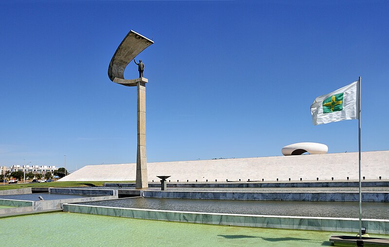
English: The JK Memorial in Brasília, dedicated to Juscelino Kubitschek (1902-1976), the founder of Brasília. The building was inaugurated in 1981. The architect is Oscar Niemeyer (1907-2012).
Čeština: Památník Juscelina Kubitscheka, věnováno Juscelinu Kubitschekovi de Oliveirovi (1902-1976), zakladateli Brasilie. Budova byla uvedena v provoz v roce 1981. Architektem byl Oscar Niemeyer (1907-2012).
Français : Le mémorial JK à Brasilia, dédié à la mémoire de Juscelino Kubitschek (1902-1976), le fondateur de Brasilia. Le mausolée, qui est l'oeuvre de l'architecte Oscar Niemeyer (1907-2012), fut inauguré en 1981.
Português: Memorial JK, dedicado a Juscelino Kubitschek (1902-1976), fundador de Brasília, capital do Brasil. O edifício, inaugurado em 1981, foi projetado pelo arquiteto Oscar Niemeyer (1907-2012).
Bosanski: Proslava dana Brasílije. Spomenik JK, posvećen Juscelinu Kubitscheku (1902-1976), osnivaču Brasílije, glavnog grada Brazila.
Deutsch: Denkmal zu Ehren Juscelino Kubitscheks (1902-1976), dem Gründer der brasilianischen Hauptstadt Brasília.
Español: El Memorial JK, dedicado a Juscelino Kubitschek (1902-1976), el fundador de Brasilia. El edificio fue diseñado por Oscar Niemeyer (1907-2012) e inaugurado en 1981.
Magyar: Juscelino Kubitscheknek, Brazíliaváros alapítójának szentelt JK-emlékmű Brazíliaváros évfordulóján
Italiano: Il memoriale dedicato a Juscelino Kubitschek de Oliveira a Brasilia, inaugurato nel 1981 e progettato da Oscar Niemeyer.
한국어: 브라질 건국일, 수도 브라질리아의 설립자 주셀리누 쿠비체크 (1902-1976)에 헌정된 JK 기념탑에서. 1981년에 개관한 이 건물은 오스카르 니에메예르 (1907-2012)가 건축하였다.
Nederlands: Een aan de voormalige Braziliaanse president Juscelino Kubitschek gewijd gedenkteken in de Braziliaanse hoofdstad Brasilia. |
| Date | |
| Source | Own work |
| Author | Cayambe |
| Other versions |
|

| Camera location | | View this and other nearby images on: OpenStreetMap |
|---|
|
This image was selected as picture of the day on Wikimedia Commons for 21 April 2015. It was captioned as follows: English: On Brasília's Anniversary, the JK Memorial, dedicated to Juscelino Kubitschek (1902-1976), the founder of Brasília, capital of Brazil. The building, inaugurated in 1981, was architected by Oscar Niemeyer (1907-2012). Other languages:
Bosanski: Proslava dana Brasílije. Spomenik JK, posvećen Juscelinu Kubitscheku (1902-1976), osnivaču Brasílije, glavnog grada Brazila. Čeština: Památník věnovaný brazilskému prezidentovi Juscelinu Kubitschek de Oliveirovi (1902-1976), umístěný v hlavním městě Brasílii, jehož je zakladatelem. Autorem památníku je brazilský architekt Oscar Niemeyer (1907-2012). Deutsch: Denkmal zu Ehren Juscelino Kubitscheks (1902-1976), dem Gründer der brasilianischen Hauptstadt Brasília. English: On Brasília's Anniversary, the JK Memorial, dedicated to Juscelino Kubitschek (1902-1976), the founder of Brasília, capital of Brazil. The building, inaugurated in 1981, was architected by Oscar Niemeyer (1907-2012). Español: El Memorial JK, dedicado a Juscelino Kubitschek (1902-1976), el fundador de Brasilia. El edificio fue diseñado por Oscar Niemeyer (1907-2012) e inaugurado en 1981. Italiano: Il memoriale dedicato a Juscelino Kubitschek de Oliveira a Brasilia, inaugurato nel 1981 e progettato da Oscar Niemeyer. Magyar: Juscelino Kubitscheknek, Brazíliaváros alapítójának szentelt JK-emlékmű Brazíliaváros évfordulóján Nederlands: Een aan de voormalige Braziliaanse president Juscelino Kubitschek gewijd gedenkteken in de Braziliaanse hoofdstad Brasilia. Português: No aniversário de Brasília, o Memorial JK, dedicado a Juscelino Kubitschek (1902-1976), fundador de Brasília, capital do Brasil. O edifício, inaugurado em 1981, foi projetado pelo arquiteto Oscar Niemeyer (1907-2012). 한국어: 브라질 건국일, 수도 브라질리아의 설립자 주셀리누 쿠비체크 (1902-1976)에 헌정된 JK 기념탑에서. 1981년에 개관한 이 건물은 오스카르 니에메예르 (1907-2012)가 건축하였다. |
This image has been assessed using the Quality image guidelines and is considered a Quality image.
|
Licensing
I, the copyright holder of this work, hereby publish it under the following license:
This file is licensed under the Creative Commons Attribution-Share Alike 3.0 Unported license.
- You are free:
- to share – to copy, distribute and transmit the work
- to remix – to adapt the work
- Under the following conditions:
- attribution – You must give appropriate credit, provide a link to the license, and indicate if changes were made. You may do so in any reasonable manner, but not in any way that suggests the licensor endorses you or your use.
- share alike – If you remix, transform, or build upon the material, you must distribute your contributions under the same or compatible license as the original.
File history
Click on a date/time to view the file as it appeared at that time.
| Date/Time | Thumbnail | Dimensions | User | Comment | |
|---|---|---|---|---|---|
| current | 09:28, 8 October 2012 | | 4,311 × 2,744 (4.79 MB) | Cayambe | User created page with UploadWizard |
File usage
The following 2 pages use this file:
Global file usage
The following other wikis use this file:
- Usage on be-tarask.wikipedia.org
- Usage on bn.wikipedia.org
- Usage on crh.wikipedia.org
- Usage on cs.wikipedia.org
- Usage on cv.wikipedia.org
- Usage on en.wikipedia.org
- Usage on fr.wikipedia.org
- Usage on hu.wikipedia.org
- Usage on it.wikipedia.org
- Usage on it.wiktionary.org
- Usage on ka.wikipedia.org
- Usage on ko.wikipedia.org
- Usage on krc.wikipedia.org
- Usage on lbe.wikipedia.org
- Usage on lb.wikipedia.org
- Usage on lmo.wikipedia.org
- Usage on nl.wikipedia.org
- Usage on os.wikipedia.org
- Usage on pt.wikipedia.org
- Usage on ru.wikipedia.org
- Usage on ru.wikinews.org
- Usage on sah.wikipedia.org
- Usage on tt.wikipedia.org
- Usage on uk.wikipedia.org
- Usage on vi.wikipedia.org
- Usage on zh.wikipedia.org