File:Panama Regions map.png
Jump to navigation
Jump to search
Size of this preview: 800 × 370 pixels. Other resolutions: 320 × 148 pixels | 640 × 296 pixels | 1,024 × 473 pixels | 1,280 × 592 pixels | 2,479 × 1,146 pixels.
Original file (2,479 × 1,146 pixels, file size: 851 KB, MIME type: image/png)
This is a file from the Wikimedia Commons and may be used by other projects. Information from its description page there is shown below.
Commons is a freely licensed media file repository. |
Summary
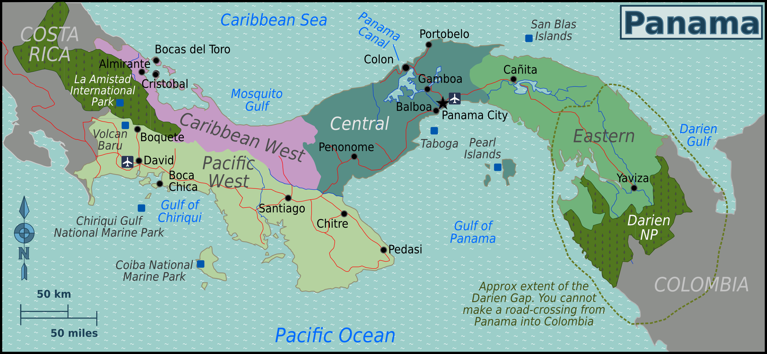
| Description | Map of Panama with regions colour coded, for use on Wikivoyage, English version |
| Date | |
| Source | Own work based on Perry-Castañeda Library Map Collection Panama Maps and OpenStreetMap |
| Author | Burmesedays, |
| Other versions |
.png)
Licensing
This file is licensed under the Creative Commons Attribution-Share Alike 3.0 Unported license.
- You are free:
- to share – to copy, distribute and transmit the work
- to remix – to adapt the work
- Under the following conditions:
- attribution – You must give appropriate credit, provide a link to the license, and indicate if changes were made. You may do so in any reasonable manner, but not in any way that suggests the licensor endorses you or your use.
- share alike – If you remix, transform, or build upon the material, you must distribute your contributions under the same or compatible license as the original.
Original upload log
| This file was imported from Wikivoyage WTS. |
The original description page was here. All following user names refer to wts.wikivoyage-old.
- 2011-08-03 09:26 (WT-shared) Burmesedays[dead link] 2485×1149 (723813 bytes) {{Imagecredit|credit=[[User:Burmesedays]], [http://lib.utexas.edu/maps/panama.html Perry-Castañeda Library Map Collection Panama Maps], [ht (Import from wikitravel.org/shared)
- 2011-08-03 14:14 (WT-shared) Burmesedays[dead link] 2485×1149 (775253 bytes) minor fixes (Import from wikitravel.org/shared)
- 2011-08-06 07:11 (WT-shared) Burmesedays[dead link] 2485×1149 (857088 bytes) fixes as per talk (Import from wikitravel.org/shared)
- 2011-08-07 06:51 (WT-shared) Burmesedays[dead link] 2485×1149 (859142 bytes) (Import from wikitravel.org/shared)
- 2011-09-15 02:05 (WT-shared) Joelf[dead link] 2479×1146 (871846 bytes) Minor fix + Panama Canal (Import from wikitravel.org/shared)
File history
Click on a date/time to view the file as it appeared at that time.
| Date/Time | Thumbnail | Dimensions | User | Comment | |
|---|---|---|---|---|---|
| current | 16:18, 23 December 2012 | | 2,479 × 1,146 (851 KB) | OgreBot | (BOT): Reverting to most recent version before archival |
| 16:18, 23 December 2012 |  | 2,485 × 1,149 (839 KB) | OgreBot | (BOT): Uploading old version of file from wts.wikivoyage; originally uploaded on 2011-08-07 06:51:11 by (WT-shared) Burmesedays | |
| 16:18, 23 December 2012 |  | 2,485 × 1,149 (837 KB) | OgreBot | (BOT): Uploading old version of file from wts.wikivoyage; originally uploaded on 2011-08-06 07:11:46 by (WT-shared) Burmesedays | |
| 16:18, 23 December 2012 |  | 2,485 × 1,149 (757 KB) | OgreBot | (BOT): Uploading old version of file from wts.wikivoyage; originally uploaded on 2011-08-03 14:14:06 by (WT-shared) Burmesedays | |
| 16:18, 23 December 2012 |  | 2,485 × 1,149 (707 KB) | OgreBot | (BOT): Uploading old version of file from wts.wikivoyage; originally uploaded on 2011-08-03 09:26:45 by (WT-shared) Burmesedays | |
| 01:55, 18 November 2012 |  | 2,479 × 1,146 (851 KB) | MGA73bot2 | {{BotMoveToCommons|wts.oldwikivoyage|year={{subst:CURRENTYEAR}}|month={{subst:CURRENTMONTHNAME}}|day={{subst:CURRENTDAY}}}} == {{int:filedesc}} == {{Information |description=Map of Panama with regions colour coded. PNG English version, Panama * Map of:... |
File usage
The following 3 pages use this file:
Global file usage
The following other wikis use this file:
- Usage on he.wikivoyage.org
- Usage on incubator.wikimedia.org
- Usage on it.wikivoyage.org
- Usage on ja.wikivoyage.org
- Usage on ru.wikivoyage.org
- Usage on vi.wikivoyage.org
- Usage on zh.wikivoyage.org