File:SS Hypatia wreck map.png
Jump to navigation
Jump to search

Size of this preview: 501 × 600 pixels. Other resolutions: 200 × 240 pixels | 401 × 480 pixels | 642 × 768 pixels | 856 × 1,024 pixels | 1,711 × 2,048 pixels | 5,484 × 6,563 pixels.
Original file (5,484 × 6,563 pixels, file size: 1.79 MB, MIME type: image/png)
This is a file from the Wikimedia Commons and may be used by other projects. Information from its description page there is shown below.
Commons is a freely licensed media file repository. |
Summary
| Description |
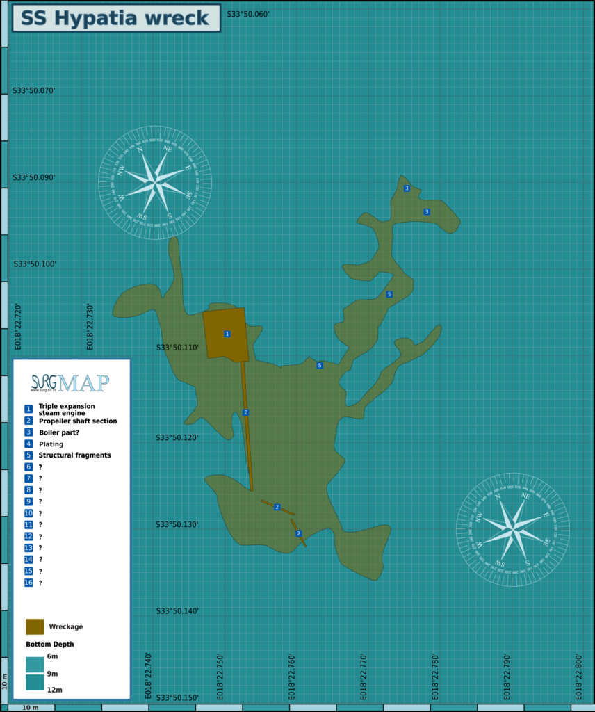
English: Map of the dive site at the wreck of the SS Hypatia, Cape Town. |
| Date | |
| Source | Peter Southwood |
| Author | Peter Southwood |
Licensing
Peter Southwood (User:Pbsouthwood), the copyright holder of this work, hereby publishes it under the following license:
This file is licensed under the Creative Commons Attribution-Share Alike 3.0 Unported license.
Attribution: Peter Southwood (User:Pbsouthwood)
- You are free:
- to share – to copy, distribute and transmit the work
- to remix – to adapt the work
- Under the following conditions:
- attribution – You must give appropriate credit, provide a link to the license, and indicate if changes were made. You may do so in any reasonable manner, but not in any way that suggests the licensor endorses you or your use.
- share alike – If you remix, transform, or build upon the material, you must distribute your contributions under the same or compatible license as the original.
Original upload log
| This file was imported from Wikivoyage WTS. |
The original description page was here. All following user names refer to wts.wikivoyage-old.
org:
- 2011-08-25 10:59 (WT-shared) Pbsouthwood[dead link] 2507×3000 (608848 bytes) {{Imagecredit|credit=Peter Southwood|captureDate=August 2011|location=Cape Town|source=Peter Southwood|caption=Map of the dive site at the w (Import from wikitravel.org/shared)
- 2012-09-07 18:01 Pbsouthwood[dead link] 2507×3000 (611365 bytes) rm logo
File history
Click on a date/time to view the file as it appeared at that time.
| Date/Time | Thumbnail | Dimensions | User | Comment | |
|---|---|---|---|---|---|
| current | 15:59, 19 December 2018 | | 5,484 × 6,563 (1.79 MB) | Pbsouthwood | extent of debris field updated |
| 12:18, 16 July 2017 |  | 5,473 × 6,549 (1.57 MB) | Pbsouthwood | corrected coordinates | |
| 01:02, 19 December 2012 |  | 2,507 × 3,000 (597 KB) | OgreBot | (BOT): Reverting to most recent version before archival | |
| 01:02, 19 December 2012 |  | 2,507 × 3,000 (595 KB) | OgreBot | (BOT): Uploading old version of file from wts.wikivoyage; originally uploaded on 2011-08-25 10:59:04 by (WT-shared) Pbsouthwood | |
| 19:32, 15 November 2012 |  | 2,507 × 3,000 (597 KB) | MGA73bot2 | {{BotMoveToCommons|wts.oldwikivoyage|year={{subst:CURRENTYEAR}}|month={{subst:CURRENTMONTHNAME}}|day={{subst:CURRENTDAY}}}} == {{int:filedesc}} == {{Information |description=Map of the dive site at the wreck of the SS Hypatia. , Cape Town |date=August ... |
File usage
The following 3 pages use this file:
Global file usage
The following other wikis use this file:
- Usage on www.wikidata.org