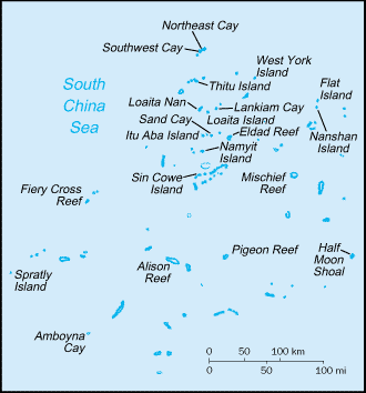
File:Spratly Islands-CIA WFB Map.png
Jump to navigation
Jump to search

No higher resolution available.
Spratly_Islands-CIA_WFB_Map.png (330 × 354 pixels, file size: 8 KB, MIME type: image/png)
This is a file from the Wikimedia Commons and may be used by other projects. Information from its description page there is shown below.
Commons is a freely licensed media file repository. |
This image is in the public domain because it contains materials that originally came from the United States Central Intelligence Agency's World Factbook.
|
 |
http://www.lib.utexas.edu/maps/cia03/spratly_islands_sm03.gif
File history
Click on a date/time to view the file as it appeared at that time.
| Date/Time | Thumbnail | Dimensions | User | Comment | |
|---|---|---|---|---|---|
| current | 09:18, 27 March 2005 | | 330 × 354 (8 KB) | Wolfman~commonswiki | {{CIA-map}} |
File usage
The following page uses this file:
Global file usage
The following other wikis use this file:
- Usage on ace.wikipedia.org
- Usage on ar.wikipedia.org
- Usage on ast.wikipedia.org
- Usage on az.wikipedia.org
- Usage on bg.wikipedia.org
- Usage on bn.wikipedia.org
- Usage on ca.wikipedia.org
- Usage on cs.wikipedia.org
- Usage on de.wikipedia.org
- Usage on de.wikinews.org
- Usage on en.wikipedia.org
- Usage on en.wikisource.org
- Usage on es.wikipedia.org
- Usage on eu.wikipedia.org
- Usage on fo.wikipedia.org
- Usage on fr.wikipedia.org
- Usage on ga.wikipedia.org
- Usage on gl.wikipedia.org
- Usage on he.wikipedia.org
- Usage on hr.wikipedia.org
- Usage on hu.wikipedia.org
- Usage on id.wikipedia.org
- Usage on it.wikipedia.org
- Usage on it.wikivoyage.org
- Usage on ja.wikipedia.org
View more global usage of this file.