File:Tianjin Metro System Map 1.png
Jump to navigation
Jump to search

Size of this preview: 800 × 480 pixels. Other resolutions: 320 × 192 pixels | 1,024 × 614 pixels | 1,280 × 767 pixels | 2,560 × 1,535 pixels | 3,866 × 2,318 pixels.
Original file (3,866 × 2,318 pixels, file size: 539 KB, MIME type: image/png)
This is a file from the Wikimedia Commons and may be used by other projects. Information from its description page there is shown below.
Commons is a freely licensed media file repository. |
Summary
| Description |
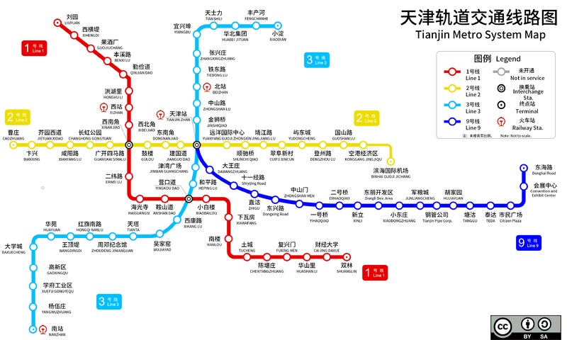
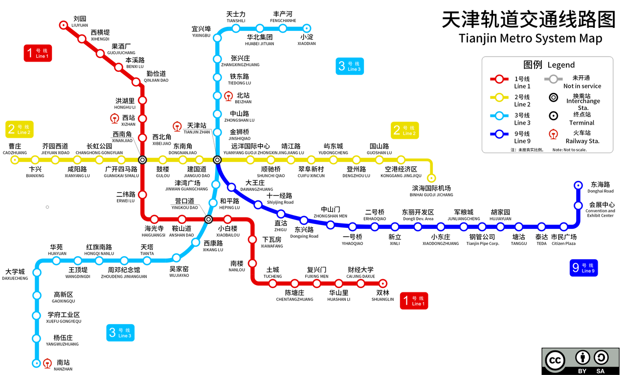
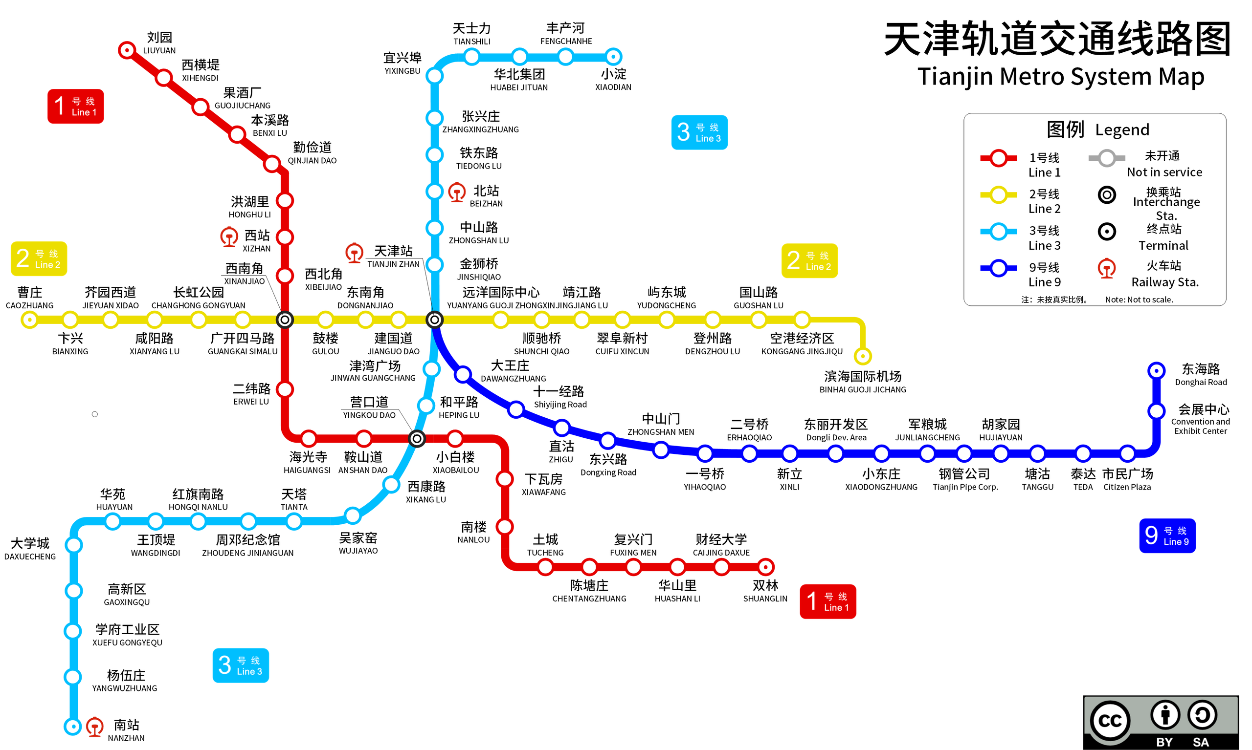
English: This is a map of the Tianjin Metro system (as of Oct, 2012). An alternative edition for File:Tianjin_Metro_System_Map.png. The only difference is Line 9. There is also a Chinese version of this image.
中文(中国大陆):这是天津轨道交通图(截至2014年1月)。该图是File:Tianjin_Metro_System_Map.png的一个替代版本。两者唯一的不同是九号线走向。另外提供纯中文版。 |
| Date | |
| Source | Own work |
| Author | User:Kuailong |
| Other versions |
 |

|
This transport map image could be re-created using vector graphics as an SVG file. This has several advantages; see Commons:Media for cleanup for more information. If an SVG form of this image is available, please upload it and afterwards replace this template with
{{vector version available|new image name}}.
It is recommended to name the SVG file “Tianjin Metro System Map 1.svg”—then the template Vector version available (or Vva) does not need the new image name parameter. |
Licensing
I, the copyright holder of this work, hereby publish it under the following license:
This file is licensed under the Creative Commons Attribution-Share Alike 3.0 Unported license.
- You are free:
- to share – to copy, distribute and transmit the work
- to remix – to adapt the work
- Under the following conditions:
- attribution – You must give appropriate credit, provide a link to the license, and indicate if changes were made. You may do so in any reasonable manner, but not in any way that suggests the licensor endorses you or your use.
- share alike – If you remix, transform, or build upon the material, you must distribute your contributions under the same or compatible license as the original.
File history
Click on a date/time to view the file as it appeared at that time.
| Date/Time | Thumbnail | Dimensions | User | Comment | |
|---|---|---|---|---|---|
| current | 17:05, 29 August 2014 | | 3,866 × 2,318 (539 KB) | Kuailong | Binhai Int'l Airport Station(BINHAI GUOJI JICHANG) is now in service. |
| 23:32, 2 February 2014 |  | 2,551 × 1,519 (358 KB) | Kuailong | The southern extension of Line 3 is now in service. | |
| 22:03, 30 August 2013 |  | 2,555 × 1,519 (397 KB) | Kuailong | JIANGUODAO station is now in service. Line 2 is now operated as a single line. | |
| 04:47, 3 January 2013 |  | 2,555 × 1,519 (399 KB) | Kuailong | select the wrong file | |
| 04:45, 3 January 2013 |  | 2,555 × 1,519 (399 KB) | Kuailong | several modifications | |
| 04:45, 3 January 2013 | No thumbnail | (507 KB) | Kuailong | several modifications | |
| 03:47, 4 December 2012 |  | 2,555 × 1,519 (400 KB) | Kuailong | Stations under construction in Line 2 (Binhai Int'l Airport) and Line 3 ( XUEFUGONGYEQU - NANZHAN ) added Icons indicate railway stations added. | |
| 03:31, 18 November 2012 |  | 2,513 × 1,288 (362 KB) | Kuailong | JIEYUANXUIDAO Station is now in service. | |
| 09:20, 2 November 2012 |  | 2,513 × 1,288 (364 KB) | Kuailong | revised version | |
| 16:04, 29 October 2012 |  | 2,528 × 1,289 (338 KB) | Kuailong | several changes |
File usage
The following page uses this file:
Global file usage
The following other wikis use this file:
- Usage on de.wikipedia.org
- Usage on eu.wikipedia.org
- Usage on fr.wikipedia.org
- Usage on he.wikivoyage.org
- Usage on hu.wikipedia.org
- Usage on id.wikipedia.org
- Usage on it.wikipedia.org
- Usage on pl.wikivoyage.org
- Usage on th.wikipedia.org
- Usage on tr.wikipedia.org
- Usage on www.wikidata.org