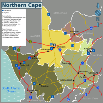
The Northern Cape, in the north-west corner of South Africa, is its largest and least populated province with only a population of 1,303,047 (2021). Distances between towns are enormous due to its sparse population. It is slightly larger than Germany, which has 65 times more people.
Regions[edit]
The Northern Cape can be divided into the following regions:

| Diamond Fields A mining and agricultural district surrounding the city of Kimberley, and its famous "Big Hole" |
| Northern Cape Karoo The “Place of Thirst” - is a boundless area covered by vast sheep and game farms, where broad plains roll away toward distant koppies and multilayered mountains that seem to touch the indigo sky |
| Namakwa A land of ancient history, lava mountains that display impossible rock formations, and nature reserves that are full of game and birdlife |
| Green Kalahari Famous for Augrabies Falls, an awe-inspiring waterfall, and for the Kgalagadi Transfrontier Park, a desert landscape with migrating herds of animals and unending red dunes |
| Kalahari Home of the biggest natural fountain in the southern hemisphere |
Cities[edit]

- 1 Kimberley — famous for its Big Hole, the world's largest hand-dug excavation
- 2 Upington — a good starting point to the famous Augrabies Falls
- 3 Kuruman — known for its scenic beauty and the Eye of Kuruman, a deep spring
- 4 Springbok — visitors are drawn for the area's high floral diversity
- 5 Colesberg — renowned for producing high-quality racehorses and many stud farms
- 6 Orania — a last outpost of Apartheid
Other places[edit]
National parks[edit]

- 1 Ai-Ais/Richtersveld Transfrontier Park — straddles the border between Namibia and South Africa
- 2 Augrabies Falls National Park — awe-inspiring waterfalls when the river is in flood
- 3 Kgalagadi Transfrontier Park — a majestic and infinite desert landscape with migrating herds
- 4 Namaqua National Park — famous for the flowering in Spring
- 5 Tankwa Karoo National Park
- 6 Mokala National Park — the newest park in South Africa, replaces the old Vaalbos National Park.
Other nature reserves[edit]
- Goegap Nature Reserve
- Oorlogskloof Nature Reserve
- Spitskop Nature Reserve
- Tswalu Desert Reserve
- Thuru Lodge (Private nature reserve)
- Witsand Nature Reserve
Understand[edit]
Although it is the largest of the nine provinces (361,000 km²), it has the smallest population (1.3 million in 2020).
The Northern Cape was part of the Cape Province from 1910 until 1994 when the old provincial boundaries were redrawn, and the Cape Province was split into the Northern Cape, the Western Cape and the Eastern Cape Provinces.
The Northern Cape is a dry and sparsely populated region, and much of it is semi-desert. Nevertheless, it has a beauty of its own and is a popular destination for South African and international tourists alike.
- Tourism House, ,14 Villiers Street, Kimberley, ☏ +27 53 832 2657.
Get in[edit]
By car[edit]
The Northern Cape Province is served by a number of excellent national roads.
- The N1 runs from Cape Town to Gauteng via the south-eastern edge of the Northern Cape and Bloemfontein.
- The N7 runs from Cape Town and the Western Cape, goes through Springbok and then on up north to Namibia.
- The N8 runs from near Upington across through Kimberley and Bloemfontein, and then goes on to Maseru Bridge (border post to Lesotho).
- The N10 runs from the Namibia border down through Upington and then on to Port Elizabeth in the Eastern Cape.
- The N12 runs from George in the Western Cape to Gauteng, going via Kimberley.
- The N14 runs from Springbok to Upington and then on to Johannesburg and Pretoria in Gauteng.
By plane[edit]
Upington Airport[dead link] and Kimberley Airport[dead link] have flights to some of the major cities in South Africa, operated by South African Airways.
Get around[edit]
Public transport is limited, so your best option is by car. Remember to fuel up whenever you can, as distances between gas stations can be long.
See[edit]
- The historic diamond mining town of Kimberley with its world-famous Big Hole and many other attractions.
- The Augrabies Falls near Upington
- The Kgalagadi Transfrontier Park at the border to Botswana
Do[edit]
Stay safe[edit]
Go next[edit]
