Talk:Niger
|
Formatting and language conventions For articles about Niger, please use the 24-hour clock to show times, e.g. 09:00-12:00 and 18:00-00:00. Please show prices in this format: CFA100, and not Fr 100 or 100CFA. Please use American spelling. |
For future reference the Project:CIA World Factbook 2002 import can be found at Talk:Niger/CIA World Factbook 2002 import.
Bridge on Niger[edit]
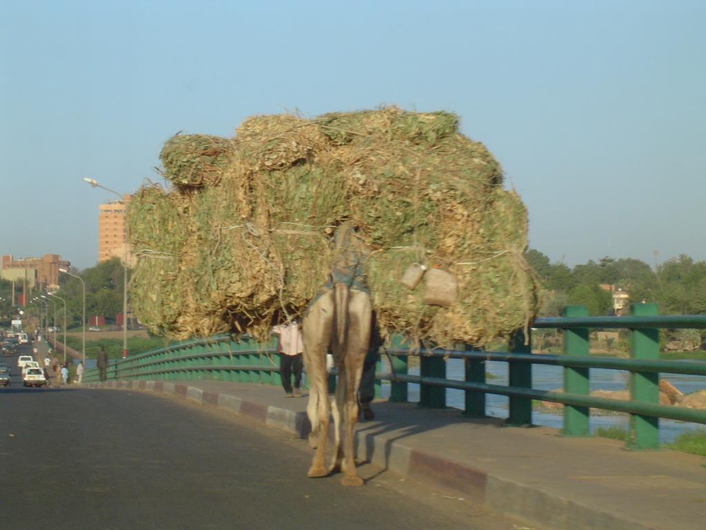
 In Niamey, walking across the only bridge over Niger river
 is considered risky even by the locals, and therefore should be avoided.
Could you elaborate? Didn't cross the bridge on foot myself, but have no idea why would it be risky...
Also please see this photo. People on the photo does not seem to be scared ;-) --(WT-en) JanSlupski 16:03, 1 Aug 2005 (EDT)
- Yeah, I know there's lots of people walking the bridge, as they don't have any other means on crossing the river (eg. money for the taxis) - and they've got nothing valuable with them. Still that's really the only place in Niamey where I never walked - and I walked a lot during the year I lived there - because really even the locals preferred not to walk across if they had anything valuable with them. During the one year there I heard of two robbings: one on the bridge, another in front of El Nasr -building (near rip-off row). It's not only one local who warned me against the bridge.
- I can't really tell you what kind of monsters lurk under the bridge (well, sometimes there's hippos), but the risks are supposed to involve some mean, hairy goblins (or bandits or the like, bad guys anyway), who come from under the bridge and rob all nice little people (yes, I know, but the whole society there seems to go around rumors, without anyone really never having any first hand information). (WT-en) Tommi 09:42, 17 Aug 2005 (EDT)
During the two-plus years I lived south of the bridge, I crossed it countless times, never had an incident, and never heard anyone talk about being scared to cross the bridge. I didn't hear about any robberies on the bridge, either. Lots of tourists have been robbed in the area of the Petit Marche, though. The bridge comment to me seems not confirmed enough to be in this wiki, but ... I don't know who makes those decisions. -Conifertree 17 Sept. 2006
- It's you who should make the decision. Or me, or anyone. But I've now removed the part about the bridge myself, as I feel that Niamey was really safe city and I don't want to add anything to that irrational fear these safety sections in travel guides usually cause. Safety issues are always too personal, and they can change fast. My experience is already three years old. About Petit Marche: I never had any problems near it, and I walked by it quite often even during night - though I always was pretty cautious there. (WT-en) Tommi 02:43, 7 December 2006 (EST)
2010 Coup d'etat[edit]
Added warningbox.
- yes very appropriate. I moved it to the top.--(WT-en) Burmesedays 10:20, 19 February 2010 (EST)
I am in Niger right now to be honest it is still really calm besides around the presidential palace where there are troops packing heavy but still I think it as fine as it was before the coup (which I admit is no ghana or benin or burkina faso but still)
Regions[edit]

Niger, with the size and population pretty much identical to Angola#Regions, has seven official regions that we could use. Unfortunately, they would all likely be pretty sparse, save Tillabéri. The rest have a population of 1.5–2 million, except the easternmost and northernmost, both of which are very sparsely populated.
Dividing the country otherwise, however, looks like a difficult task. The geography is either Sahel, mostly along the southern border, and the rest Saharan, so that isn't very helpful. I'm a little inclined to divide the country into a mere three regions: Southwest (Tillabére & Dosso), South, and North. The division between south and north would roughly follow the lines of population density, which tracks fairly closely with the Sahel v. Sahara split. This will necessitate using subdivisions of the regions, the departments. These departments would go to the north: for Tahoua, Tchin-Tabaraden and Abalak; for Maradi, only the northern part of Dakoro; for Zinder, Tanout and most of Goure; and for Diffa, only N'Guigmi. That's a bit complicated, but see wikipedia:File:NigerOMC.png and wikipedia:File:Niger admin.png to get an idea of what I am basing this on. --(WT-en) Peter Talk 18:10, 22 February 2010 (EST)
- See map to the right. I'll give this one more day, and if no one objects, I'll implement this new hierarchy. --(WT-en) Peter Talk 01:24, 4 March 2010 (EST)
- The divisions of regions are perfect! There are a few minor things that should (in my opinion) be added/tweaked. The road from Niamey to Gao has been paved recently and from lots of travel accounts, etc, I gather it's a major road and should be red. The road/piste from Agadez up to Tamanrasset is a major road (although currently not for tourists due to unrest) across the Sahara...in fact, it's just about the only trans-Sahara route in use between Egypt-Sudan to east and Morocco-Mauritania in the west! It's worth making at least a dashed red line. The Air & Tenere National Reserve is a major draw near Agadez (at least when it's safe) and Bilma and Chirfa are tiny, remote outposts, but gateways nevertheless to the remote Tenere desert and Djado Plateau. (WT-en) AHeneen 21:21, 4 March 2010 (EST)
- Done. --(WT-en) Peter Talk 18:09, 9 March 2010 (EST)
Merge all regions[edit]
Given the general emptiness of the region articles and the lack of city articles contained therein, should the regions be merged? Hobbitschuster (talk) 14:16, 30 November 2017 (UTC)
Support Ground Zero (talk) 13:43, 24 December 2017 (UTC)- I'm changing my mind on this to oppose -- a country the size of Niger should be split up into regions, even if it's not yet ready for mass tourism that would support more city articles than we have now. Ground Zero (talk) 20:16, 13 November 2018 (UTC)
- I don't see why the area involved is relevant. Anticosti is covered by one city article despite its size. Ditto, and maybe more relevantly, for Empty Quarter. Ikan Kekek (talk) 21:17, 13 November 2018 (UTC)
- Anticosti has a population of 240, while Rub' al Khali is a largely empty quarter of a country that does not issue tourist visas. There seems to be little potential for article creation in either of these regions. Niger, on the other hand, has 21 million people in lots of cities and towns (and is 160 times the size of Anticosti Island). We just don't have articles for them yet. In the unlikely event someone were able to write articles about lots of places in Anticosti and Rub' al Khali, I suppose we would want to split up the articles there too. And if my mother had wheels, I suppose she might be a bus, but I don't see the point in speculating on the matter. Kind of like putting merge tags on articles when no-one, not even the person proposing the merger, is will to to merge the articles. It's just a hypothetical discussion. Better to remove the tags and let the regional articles develop when we find someone with the knowledge of the country to write the articles we know could be there. Ground Zero (talk) 21:34, 13 November 2018 (UTC)
- If you take a look at Chad, it's in a similar state. But here's the issues I see: first, you've got the problem with the static maps. It just seems like a lot of work to do all this that isn't necessary. And if someone adds more articles, then we'd have to divide it into regions again. I'm not an open oppose, though. --Comment by Selfie City (talk | contributions) 02:30, 14 November 2018 (UTC)
- Furthermore, even the proposer of this merge isn't interested in doing the work. Ground Zero (talk) 19:33, 24 November 2018 (UTC)
A Commons file used on this page or its Wikidata item has been nominated for deletion[edit]
The following Wikimedia Commons file used on this page or its Wikidata item has been nominated for deletion:
Participate in the deletion discussion at the nomination page. —Community Tech bot (talk) 10:44, 2 February 2021 (UTC)