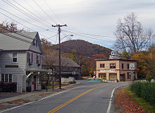
Amenia is a township in Dutchess County, New York. This page also covers the village of Wassaic, 6 miles south of downtown Amenia.
Get in
By plane
- Stewart International Airport (SWF IATA). The closest major airport, but at present offers few direct flights to major destinations.
- Westchester County Airport (HPN IATA). Two counties away, but an alternative to the congestion of the 3 major international airports around New York City. Rental cars available.
- Newark Liberty International Airport, Newark, New Jersey; John F. Kennedy International Airport; and LaGuardia Airport.
By car
Taconic State Parkway to Route 44 into Amenia.
By train

- Metro-North Railroad - Harlem line. Service between Wassaic station and New York City's Grand Central Terminal is about 2 hours. Local service is available between other Metro-North commuter stations. On-board train fares are subject to a stiff surcharge, so buy your tickets at the vending machines at the Wassaic station.
Get around
See

There are several local buildings that are listed on the National Register of Historic Places in the United States, including the Indian Rock Schoolhouse, pictured on this page.
Do
Buy
There are antique stores in the area.
Eat
Drink
Sleep
Splurge
- Troutbeck, 515 Leedsville Rd, ☏ +1 845 373-9681. In the manner of an English country estate. Has pool, fishing, tennis, hiking, health club, ballroom.
Go next
Amenia is very close to Litchfield County, Connecticut and not much farther from the Hudson Valley and the Berkshire Hills of Massachusetts.
| Routes through Amenia |
| END ← | N |
→ Brewster → White Plains |

