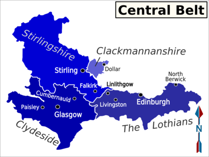
The Central Belt is in Scotland, one of the four countries that make up the United Kingdom of Great Britain and Northern Ireland. It is that part of the country which stretches from Glasgow in the west to Edinburgh in the east, and contains the majority of the population. The region varies greatly, from the cities of Glasgow, Edinburgh and the ancient capital, Dunfermline, to the rural areas of the South Region.
Regions

| Clydeside the area around Glasgow |
| The Lothians the area around Edinburgh |
| Stirlingshire the mountainous, more rural county in the north of the region |
| Clackmannanshire a small county east of Stirlingshire |
Cities and towns
Cities
Towns
Other destinations
Elderslie This is a small Village situated between the towns of Paisley and Johnstone. It is the birthplace of William Wallace.
Understand
Talk
Get in
There are three major airports in this area of Scotland. One serving the capital, Edinburgh, and two serving Glasgow.
Trains from England arrive in the main rail stations in Glasgow and Edinburgh.
Major roads into the Central Belt are:
- M74 bringing traffic from the northwest of England and southwest of Scotland to Glasgow
- A77 bringing traffic from the southwest of Scotland to Glasgow, via Ayr
- A1 bringing traffic from the northeast of England and southeast of Scotland to Edinburgh, via Berwick-upon-Tweed and Dunbar
- A7 & A68 bringing traffic from the Scottish Borders to Edinburgh
- A9 bringing traffic from the north of Scotland to Stirling, via Inverness and Perth
- A90 bringing traffic from Aberdeen and the northeast of Scotland to Edinburgh, via Dundee and Perth
Get around
FirstScotRail currently run the rail franchise in Scotland. GNER and Virgin Trains also run passenger rail services in Scotland, but they operate long distance services and only stop in the larger rail stations.
See
Do
Eat
Drink
Sleep
Go next
