File:Замак-палац у Нясьвіжы знутры.jpg
Jump to navigation
Jump to search

Size of this preview: 800 × 533 pixels. Other resolutions: 320 × 213 pixels | 640 × 427 pixels | 1,024 × 683 pixels | 1,280 × 853 pixels | 2,560 × 1,707 pixels | 4,252 × 2,835 pixels.
Original file (4,252 × 2,835 pixels, file size: 7.82 MB, MIME type: image/jpeg)
This is a file from the Wikimedia Commons and may be used by other projects. Information from its description page there is shown below.
Commons is a freely licensed media file repository. |
Summary
| Description |
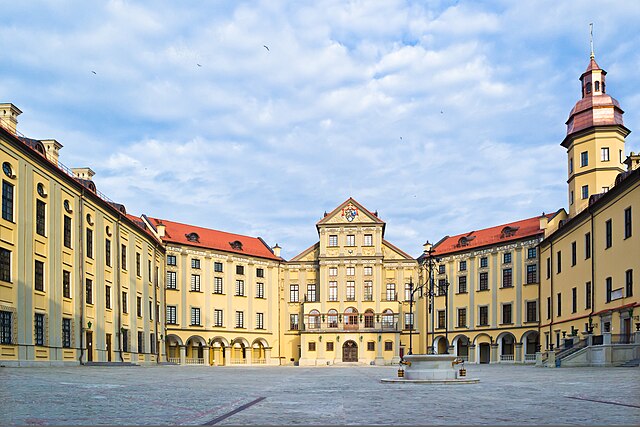
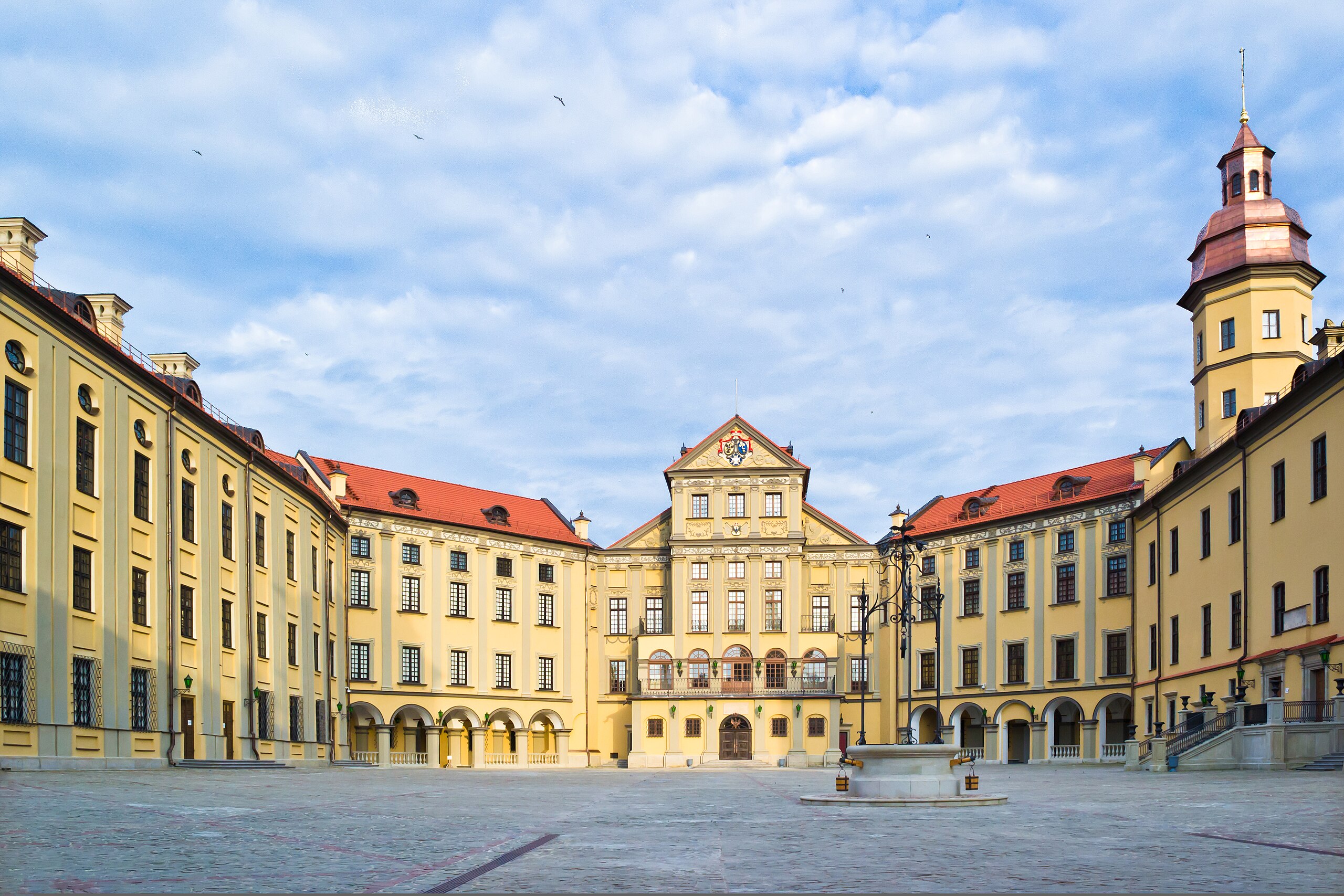
Беларуская (тарашкевіца): Палацава-паркавы ансамбль: замак-палац, паўднёвая і ўсходняя галерэі, камяніца, арсэнал з капліцай, брама, два прыбрамныя корпусы, паўночна-ўсходняя і паўднёва-заходняя галерэі, лядоўня, стайня; абарончыя збудаваньні і мост; тэрыторыя паркаў: Замкавы, Стары, Японскі, Ангельскі, Новы; водная сыстэма: Дзікі, Замкавы, Бэрнардынскі ставы. г. Нясьвіж
|
||
| Date | |||
| Source | Own work | ||
| Author | Dmitry Gerasimov |
| Camera location | | View this and other nearby images on: OpenStreetMap |
|---|
Licensing
I, the copyright holder of this work, hereby publish it under the following license:
This file is licensed under the Creative Commons Attribution-Share Alike 3.0 Unported license.
- You are free:
- to share – to copy, distribute and transmit the work
- to remix – to adapt the work
- Under the following conditions:
- attribution – You must give appropriate credit, provide a link to the license, and indicate if changes were made. You may do so in any reasonable manner, but not in any way that suggests the licensor endorses you or your use.
- share alike – If you remix, transform, or build upon the material, you must distribute your contributions under the same or compatible license as the original.

|
This image was uploaded as part of Wiki Loves Monuments 2012.
|
 |

|
This is one of the images forming part of the Valued image set: Nesvizh Castle, Belarus on Wikimedia Commons. The image set has been assessed under the valued image set criteria and is considered the most valued set on Commons within the scope:
Nesvizh Castle, Belarus
You can see its nomination at Commons:Valued image candidates/Nesvizh Castle. |
File history
Click on a date/time to view the file as it appeared at that time.
| Date/Time | Thumbnail | Dimensions | User | Comment | |
|---|---|---|---|---|---|
| current | 16:27, 10 March 2013 | | 4,252 × 2,835 (7.82 MB) | Dezonik | Fixed distortion |
| 17:05, 30 September 2012 |  | 2,400 × 1,600 (2.83 MB) | Dezonik | User created page with UploadWizard | |
| 17:05, 30 September 2012 | No thumbnail | 2,400 × 1,600 (2.85 MB) | Dezonik | User created page with UploadWizard |
File usage
The following page uses this file:
Global file usage
The following other wikis use this file:
- Usage on ar.wikipedia.org
- Usage on ast.wikipedia.org
- Usage on be.wikipedia.org
- Usage on bg.wikipedia.org
- Usage on de.wikipedia.org
- Usage on en.wikipedia.org
- Usage on eo.wikipedia.org
- Usage on es.wikipedia.org
- Usage on fi.wikipedia.org
- Usage on fr.wikipedia.org
- Usage on fr.wikivoyage.org
- Usage on he.wikipedia.org
- Usage on hr.wikipedia.org
- Usage on hu.wikipedia.org
- Usage on hy.wikipedia.org
- Usage on io.wikipedia.org
- Usage on it.wikipedia.org
- Usage on ja.wikipedia.org
- Usage on ka.wikipedia.org
- Usage on lt.wikipedia.org
- Usage on lv.wikipedia.org
- Usage on mt.wikipedia.org
- Usage on nl.wikipedia.org
- Usage on no.wikipedia.org
- Usage on pl.wikipedia.org
View more global usage of this file.