File:Aerial image of Heligoland.jpg
Jump to navigation
Jump to search

Size of this preview: 800 × 520 pixels. Other resolutions: 320 × 208 pixels | 640 × 416 pixels | 1,024 × 666 pixels | 1,280 × 832 pixels | 2,560 × 1,664 pixels | 4,000 × 2,600 pixels.
Original file (4,000 × 2,600 pixels, file size: 3.13 MB, MIME type: image/jpeg)
This is a file from the Wikimedia Commons and may be used by other projects. Information from its description page there is shown below.
Commons is a freely licensed media file repository. |
Summary
| Description |
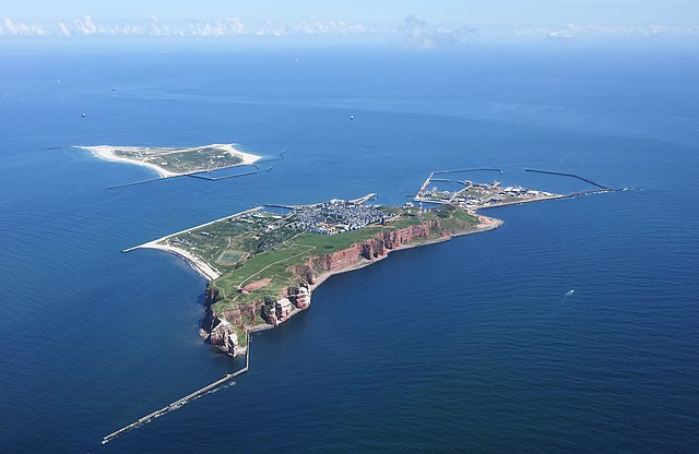
English: Aerial image of Heligoland
Deutsch: Luftbild von Helgoland |
| Date | |
| Source | Own work |
| Author | Carsten Steger |
| Camera location | | View this and other nearby images on: OpenStreetMap |
|---|
| Object location | | View this and other nearby images on: OpenStreetMap |
|---|
Licensing
I, the copyright holder of this work, hereby publish it under the following license:
This file is licensed under the Creative Commons Attribution-Share Alike 4.0 International license.
- You are free:
- to share – to copy, distribute and transmit the work
- to remix – to adapt the work
- Under the following conditions:
- attribution – You must give appropriate credit, provide a link to the license, and indicate if changes were made. You may do so in any reasonable manner, but not in any way that suggests the licensor endorses you or your use.
- share alike – If you remix, transform, or build upon the material, you must distribute your contributions under the same or compatible license as the original.
This image has been assessed using the Quality image guidelines and is considered a Quality image.
|
| Annotations | This image is annotated: View the annotations at Commons |
File history
Click on a date/time to view the file as it appeared at that time.
| Date/Time | Thumbnail | Dimensions | User | Comment | |
|---|---|---|---|---|---|
| current | 21:44, 11 September 2021 | | 4,000 × 2,600 (3.13 MB) | Carsten Steger | Sharpened the image. |
| 18:38, 9 July 2021 |  | 4,000 × 2,600 (2.6 MB) | Carsten Steger | Removed two dust spots. | |
| 18:13, 9 July 2021 |  | 4,000 × 2,600 (2.6 MB) | Carsten Steger | Uploaded own work with UploadWizard |
File usage
The following 3 pages use this file:
Global file usage
The following other wikis use this file:
- Usage on ace.wikipedia.org
- Usage on an.wikipedia.org
- Usage on ar.wikipedia.org
- فريزيا (جزر)
- زولت (جزيرة)
- هيرينفين
- قالب:الجزر الفريزية
- سخيرمونيكوخ
- تيرشخيلينج
- أمالاند
- دانتوماديل
- دونجراديل
- فيرفيرديراديل
- دي فريسكه مارين
- فرانيكراديل
- أوستستالينجفيرف
- أوبسترلاند
- فليلاند
- تيسل
- الجزر الفريزية الغربية
- بوركوم
- نوردرناي
- تصنيف:جزر فريزية
- نورديرهاكس
- ريخل
- خريند
- ريف (جزيرة)
- إنجلسمانبلات
- سيمونزاند
- روتوميربلات
- روتوميرأوخ
- زاود داونتشيز
- فيرينجن
- الجزر الفريزية الشرقية
- لوتشيا هورن
- كاخيلوتبلاته
- ميمرت
- ياوست
- بالتروم
- لانجه أوخ
- سبيكيرأوخ
- فانجر أوخه
- مينسينرأوخ
- ميلوم
- باوسه
- نورك
- قائمة جزر ألمانيا
- الجزر الفريزية الشمالية
- جزيرة لوهيسن
- جزيرة فوهر
View more global usage of this file.