File:Anjouan topographic map-en.svg
Jump to navigation
Jump to search

Size of this PNG preview of this SVG file: 734 × 600 pixels. Other resolutions: 294 × 240 pixels | 588 × 480 pixels | 940 × 768 pixels | 1,254 × 1,024 pixels | 2,507 × 2,048 pixels | 841 × 687 pixels.
Original file (SVG file, nominally 841 × 687 pixels, file size: 757 KB)
This is a file from the Wikimedia Commons and may be used by other projects. Information from its description page there is shown below.
Commons is a freely licensed media file repository. |
| Description |
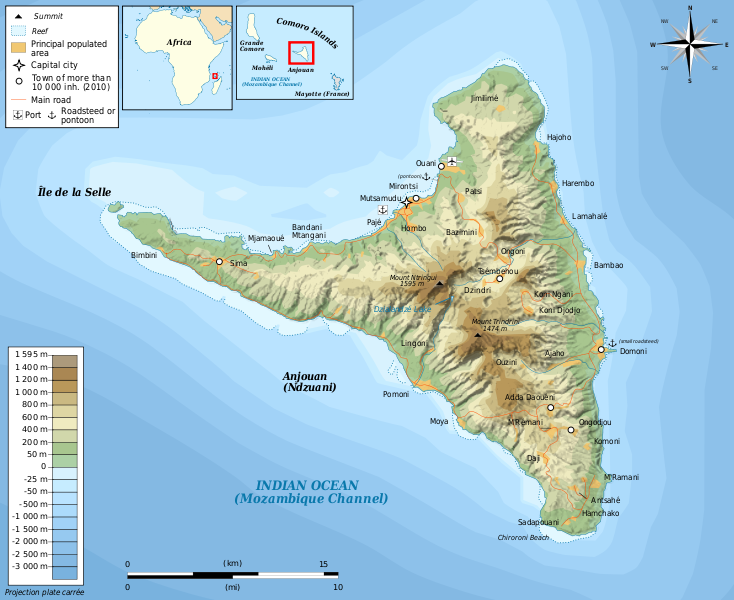
Français : Carte topographique en anglais d'Anjouan Deutsch: Topographische Karte zum Anjouan, in Englische English: Topographic map in English language of Anjouan Español: Mapa topográfico en inglès de Anjouan Italiano: Carta topografica de Anjouan 日本語: 英語で表示したアンジュアン島の地形地図 Português: Carta topográfica e da administração do Anjouan |
| Date | (UTC) |
| Source | |
| Author |
|
| This is a retouched picture, which means that it has been digitally altered from its original version. Modifications: translate. The original can be viewed here: Anjouan topographic map-fr.svg:
|
I, the copyright holder of this work, hereby publish it under the following licenses:
This file is licensed under the Creative Commons Attribution-Share Alike 3.0 Unported, 2.5 Generic, 2.0 Generic and 1.0 Generic license.
- You are free:
- to share – to copy, distribute and transmit the work
- to remix – to adapt the work
- Under the following conditions:
- attribution – You must give appropriate credit, provide a link to the license, and indicate if changes were made. You may do so in any reasonable manner, but not in any way that suggests the licensor endorses you or your use.
- share alike – If you remix, transform, or build upon the material, you must distribute your contributions under the same or compatible license as the original.

|
Permission is granted to copy, distribute and/or modify this document under the terms of the GNU Free Documentation License, Version 1.2 or any later version published by the Free Software Foundation; with no Invariant Sections, no Front-Cover Texts, and no Back-Cover Texts. A copy of the license is included in the section entitled GNU Free Documentation License. |
You may select the license of your choice.
Original upload log
This image is a derivative work of the following images:
- File:Anjouan_topographic_map-fr.svg licensed with Cc-by-sa-3.0,2.5,2.0,1.0, GFDL
- 2011-03-14T19:54:11Z Bourrichon 841x687 (782118 Bytes)
- 2011-03-13T20:31:42Z Bourrichon 841x687 (781398 Bytes)
- 2011-03-13T15:40:15Z Bourrichon 841x687 (781390 Bytes) {{Location|12|13|30|S|44|22|30|E|scale:500000}} {{Information |Description= {{fr|Carte topographique en français d'[[:fr:Anjouan|]]}}{{de|Topographische Karte zum [[:de:Anjouan|]], in Französische}}{{en|Topographic map in F
Uploaded with derivativeFX
File history
Click on a date/time to view the file as it appeared at that time.
| Date/Time | Thumbnail | Dimensions | User | Comment | |
|---|---|---|---|---|---|
| current | 16:20, 15 March 2011 | | 841 × 687 (757 KB) | Bourrichon | {{Information |Description={{fr|Carte topographique en anglais d'Anjouan}}{{de|Topographische Karte zum Anjouan, in Englische}}{{en|Topographic map in English language of Anjouan}}{{es|Mapa topográfico en i |
File usage
The following page uses this file:
Global file usage
The following other wikis use this file:
- Usage on az.wikipedia.org
- Usage on de.wikivoyage.org
- Usage on en.wikipedia.org
- Usage on ka.wikipedia.org
- Usage on nl.wikipedia.org
- Usage on pt.wikipedia.org
- Usage on ru.wikipedia.org
- Usage on www.wikidata.org
- Usage on zh.wikipedia.org