File:BARTMapDay.svg
Jump to navigation
Jump to search

Size of this PNG preview of this SVG file: 512 × 456 pixels. Other resolutions: 270 × 240 pixels | 539 × 480 pixels | 862 × 768 pixels | 1,150 × 1,024 pixels | 2,300 × 2,048 pixels.
Original file (SVG file, nominally 512 × 456 pixels, file size: 115 KB)
This is a file from the Wikimedia Commons and may be used by other projects. Information from its description page there is shown below.
Commons is a freely licensed media file repository. |

|
This file requires updating because: Map should depict new eBART line from Pittsburg/Baypoint to Antioch (and eventually the extension from Warm Springs/South Fremont to Berryessa/North San José). In doing so, you could add a timestamp to the file.
|
Summary
| Description |
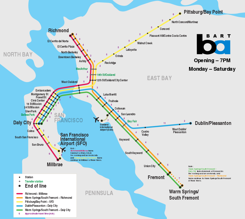
English: Bay Area Rapid Transit map showing daytime weekday and Saturday service (before 7PM). |
| Date | (UTC) |
| Source | |
| Author |
|
| Other versions | File:BARTMapNight.svg |
| SVG development | This map was created with Adobe Illustrator. |
Licensing
This file is licensed under the Creative Commons Attribution-Share Alike 3.0 Unported license.
- You are free:
- to share – to copy, distribute and transmit the work
- to remix – to adapt the work
- Under the following conditions:
- attribution – You must give appropriate credit, provide a link to the license, and indicate if changes were made. You may do so in any reasonable manner, but not in any way that suggests the licensor endorses you or your use.
- share alike – If you remix, transform, or build upon the material, you must distribute your contributions under the same or compatible license as the original.
File history
Click on a date/time to view the file as it appeared at that time.
| Date/Time | Thumbnail | Dimensions | User | Comment | |
|---|---|---|---|---|---|
| current | 01:53, 5 September 2018 | | 512 × 456 (115 KB) | Glrx | Use font properties rather than font-family to specify font-weight and font-stretch. Fallback font list. Fix "Oakland". Fix "del Norte". |
| 03:46, 11 May 2017 |  | 512 × 456 (358 KB) | Train2104 | Text not as path looks terrible | |
| 03:40, 11 May 2017 |  | 512 × 456 (115 KB) | Train2104 | Warm Springs/South Fremont, fix typo | |
| 19:12, 23 March 2015 |  | 2,300 × 2,050 (427 KB) | Train2104 | AirBART | |
| 23:27, 1 January 2013 |  | 2,300 × 2,050 (533 KB) | Ultimate Roadgeek | Finally fixed. Phew. | |
| 23:18, 1 January 2013 |  | 2,300 × 2,050 (437 KB) | Ultimate Roadgeek | Reverted to version as of 06:32, 28 December 2012 | |
| 23:16, 1 January 2013 |  | 2,300 × 2,050 (490 KB) | Ultimate Roadgeek | FIXED ISSUES | |
| 06:32, 28 December 2012 |  | 2,300 × 2,050 (437 KB) | Ultimate Roadgeek | svg had issue with layering. will reupload | |
| 06:15, 28 December 2012 |  | 2,300 × 2,050 (461 KB) | Ultimate Roadgeek | Fixed the South SF - San Bruno mix-up. Also fixed Millbrae service pattern description. | |
| 22:37, 18 February 2012 |  | 2,300 × 2,050 (437 KB) | Train2104 | Typo |
File usage
The following 3 pages use this file:
Global file usage
The following other wikis use this file:
- Usage on bg.wikipedia.org
- Usage on ca.wikipedia.org
- Usage on cy.wikipedia.org
- Usage on eo.wikipedia.org
- Usage on es.wikipedia.org
- Usage on fa.wikipedia.org
- Usage on it.wikipedia.org
- Usage on it.wikivoyage.org
- Usage on ja.wikipedia.org
- Usage on ko.wikipedia.org
- Usage on no.wikipedia.org
- Usage on pt.wikipedia.org
- Usage on sv.wikipedia.org
- Usage on th.wikipedia.org
- Usage on tr.wikipedia.org