File:Calgary CTrain Map.png
Jump to navigation
Jump to search
Size of this preview: 787 × 599 pixels. Other resolutions: 315 × 240 pixels | 630 × 480 pixels | 1,009 × 768 pixels | 1,280 × 975 pixels | 2,560 × 1,950 pixels | 3,465 × 2,639 pixels.
Original file (3,465 × 2,639 pixels, file size: 93 KB, MIME type: image/png)
This is a file from the Wikimedia Commons and may be used by other projects. Information from its description page there is shown below.
Commons is a freely licensed media file repository. |
Summary
| Description |
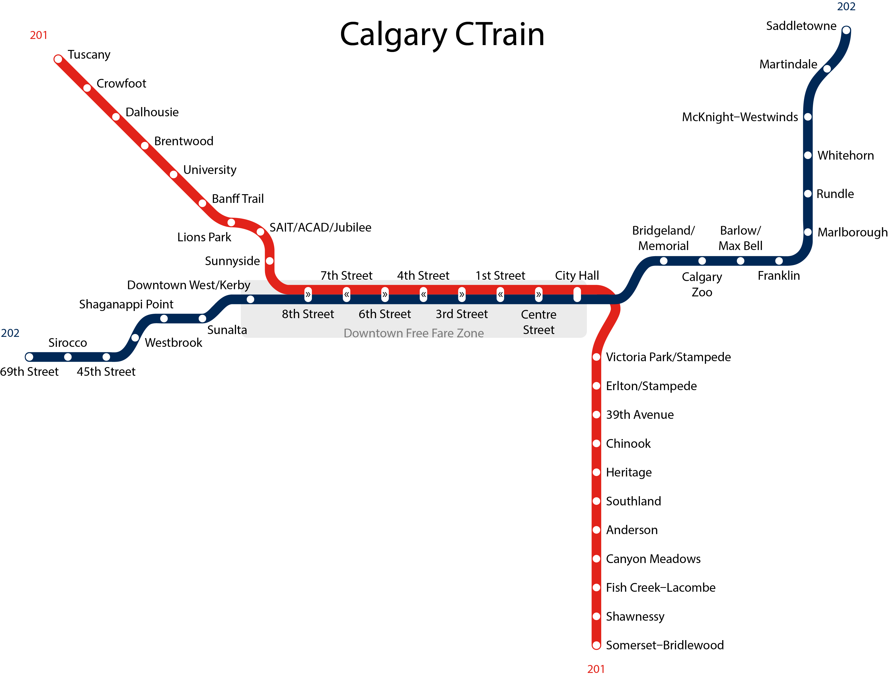
English: This is the map of Calgary's CTrain system as of January 2013. |
||
| Date | |||
| Source | Own work | ||
| Author | Ted Verhey | ||
| Other versions |
|

Licensing
I, the copyright holder of this work, hereby publish it under the following license:
This file is licensed under the Creative Commons Attribution-Share Alike 3.0 Unported license.
- You are free:
- to share – to copy, distribute and transmit the work
- to remix – to adapt the work
- Under the following conditions:
- attribution – You must give appropriate credit, provide a link to the license, and indicate if changes were made. You may do so in any reasonable manner, but not in any way that suggests the licensor endorses you or your use.
- share alike – If you remix, transform, or build upon the material, you must distribute your contributions under the same or compatible license as the original.
File history
Click on a date/time to view the file as it appeared at that time.
| Date/Time | Thumbnail | Dimensions | User | Comment | |
|---|---|---|---|---|---|
| current | 19:00, 4 July 2015 | | 3,465 × 2,639 (93 KB) | Cmdrjameson | Compressed with pngout. Reduced by 111kB (54% decrease). |
| 01:42, 14 October 2014 |  | 3,465 × 2,639 (204 KB) | Verheytb | Updated the map, with Tuscany Station and official line colours. | |
| 06:26, 21 January 2013 |  | 5,198 × 3,959 (246 KB) | Verheytb | Reverted to version as of 06:23, 21 January 2013 | |
| 06:26, 21 January 2013 |  | 5,198 × 3,959 (246 KB) | Verheytb | Fixed spelling, removed legend. | |
| 06:23, 21 January 2013 |  | 5,198 × 3,959 (246 KB) | Verheytb | Fixed spelling, removed legend. | |
| 20:27, 19 January 2013 |  | 5,198 × 3,959 (276 KB) | Verheytb | Slightly lower resolution, smaller size, so thumbnails can be rendered. | |
| 20:13, 19 January 2013 |  | 6,931 × 5,279 (611 KB) | Verheytb | User created page with UploadWizard |
File usage
There are no pages that use this file.
Global file usage
The following other wikis use this file:
- Usage on de.wikipedia.org
- Usage on en.wikipedia.org
- Usage on es.wikipedia.org
- Usage on fr.wikipedia.org
- Usage on it.wikipedia.org
- Usage on ja.wikipedia.org
- Usage on ms.wikipedia.org
- Usage on nl.wikipedia.org
- Usage on pt.wikipedia.org
- Usage on ru.wikipedia.org
- Usage on tr.wikipedia.org
- Usage on uk.wikipedia.org
- Usage on www.wikidata.org
- Usage on zh.wikipedia.org