File:Catania mappa metropolitana.svg
Jump to navigation
Jump to search

Size of this PNG preview of this SVG file: 800 × 457 pixels. Other resolutions: 320 × 183 pixels | 640 × 366 pixels | 1,024 × 585 pixels | 1,280 × 732 pixels | 2,560 × 1,464 pixels | 2,790 × 1,595 pixels.
Original file (SVG file, nominally 2,790 × 1,595 pixels, file size: 6.46 MB)
This is a file from the Wikimedia Commons and may be used by other projects. Information from its description page there is shown below.
Commons is a freely licensed media file repository. |
Summary
| Description |
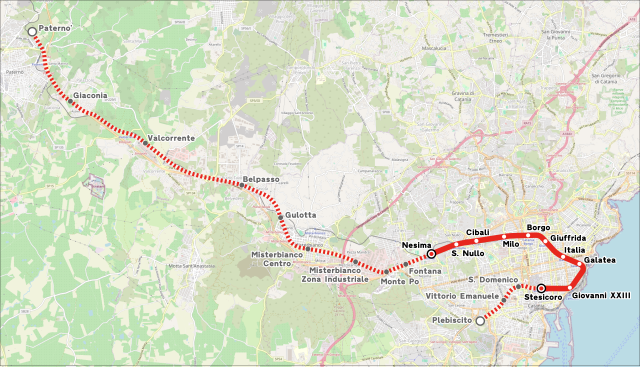
Italiano: Mappa della metropolitana di Catania. |
|||
| Date | (see file history) | |||
| Source | openstreetmap.org | |||
| Creator |
OpenStreetMap contributors |
|||
| Permission (Reusing this file) |
OpenStreetMap data is available under the Open Database License (details). Map tiles are licensed under the Creative Commons Attribution-ShareAlike 2.0 license (CC-BY-SA 2.0).
This file is licensed under the Creative Commons Attribution-Share Alike 2.0 Generic license.
|
|||
| Georeferencing | If inappropriate please set warp_status = skip to hide. |
File history
Click on a date/time to view the file as it appeared at that time.
| Date/Time | Thumbnail | Dimensions | User | Comment | |
|---|---|---|---|---|---|
| current | 03:28, 24 March 2024 | | 2,790 × 1,595 (6.46 MB) | Arbalete | Piccola correzione |
| 02:53, 24 March 2024 |  | 2,790 × 1,595 (6.46 MB) | Arbalete | Aggiorno (tratta fino a Paternò in costruzione) | |
| 20:11, 13 September 2022 |  | 1,130 × 809 (3.68 MB) | Arbalete | Aggiorno | |
| 18:42, 5 January 2017 |  | 781 × 590 (3.82 MB) | Arbalete | Aggiorno con nuove tratte in costruzione | |
| 16:09, 20 December 2016 |  | 772 × 543 (3.6 MB) | Arbalete | Aggiornamento del 20 dicembre 2016 | |
| 12:47, 10 September 2014 |  | 772 × 543 (3.59 MB) | Arbalete | Aggiunta tratta Borgo-Nesima | |
| 08:35, 9 September 2014 |  | 664 × 540 (2.76 MB) | Arbalete | Sfondo vettorializzato, aggiunta tratta in costruzione | |
| 17:23, 10 June 2014 |  | 404 × 354 (1.58 MB) | Arbalete | Nuovo font. | |
| 09:59, 6 February 2014 |  | 404 × 354 (1.57 MB) | Arbalete | Nuova grafica più chiara. | |
| 17:20, 7 December 2013 |  | 404 × 354 (1.57 MB) | Arbalete | {{Information |Description ={{it|1=Mappa della metropolitana di Catania.}} |Source ={{own}} |Author =Friedrichstrasse |Date = |Permission = |other_versions = }} |
File usage
The following page uses this file:
Global file usage
The following other wikis use this file:
- Usage on bn.wikipedia.org
- Usage on ca.wikipedia.org
- Usage on cs.wikipedia.org
- Usage on de.wikipedia.org
- Usage on de.wikivoyage.org
- Usage on el.wikipedia.org
- Usage on en.wikipedia.org
- Usage on eo.wikipedia.org
- Usage on es.wikipedia.org
- Usage on eu.wikipedia.org
- Usage on fa.wikipedia.org
- Usage on fr.wikipedia.org
- Usage on fr.wikivoyage.org
- Usage on hu.wikipedia.org
- Usage on id.wikipedia.org
- Usage on it.wikipedia.org
- Usage on ja.wikipedia.org
- Usage on ka.wikipedia.org
- Usage on ko.wikipedia.org
- Usage on lmo.wikipedia.org
- Usage on lt.wikipedia.org
- Usage on mt.wikipedia.org
- Usage on nl.wikipedia.org
- Usage on pl.wikipedia.org
- Usage on pt.wikipedia.org
- Usage on ru.wikipedia.org
- Usage on ru.wikivoyage.org
- Usage on sk.wikipedia.org
- Usage on sv.wikipedia.org
- Usage on th.wikipedia.org
- Usage on tr.wikipedia.org
- Usage on uz.wikipedia.org
- Usage on www.wikidata.org
View more global usage of this file.