File:Crozet Map.png
Jump to navigation
Jump to search
Size of this preview: 800 × 473 pixels. Other resolutions: 320 × 189 pixels | 640 × 378 pixels | 1,024 × 605 pixels | 1,280 × 757 pixels | 2,280 × 1,348 pixels.
Original file (2,280 × 1,348 pixels, file size: 246 KB, MIME type: image/png)
This is a file from the Wikimedia Commons and may be used by other projects. Information from its description page there is shown below.
Commons is a freely licensed media file repository. |

|
This map image could be re-created using vector graphics as an SVG file. This has several advantages; see Commons:Media for cleanup for more information. If an SVG form of this image is available, please upload it and afterwards replace this template with
{{vector version available|new image name}}.
It is recommended to name the SVG file “Crozet Map.svg”—then the template Vector version available (or Vva) does not need the new image name parameter. |
Summary
| Description |
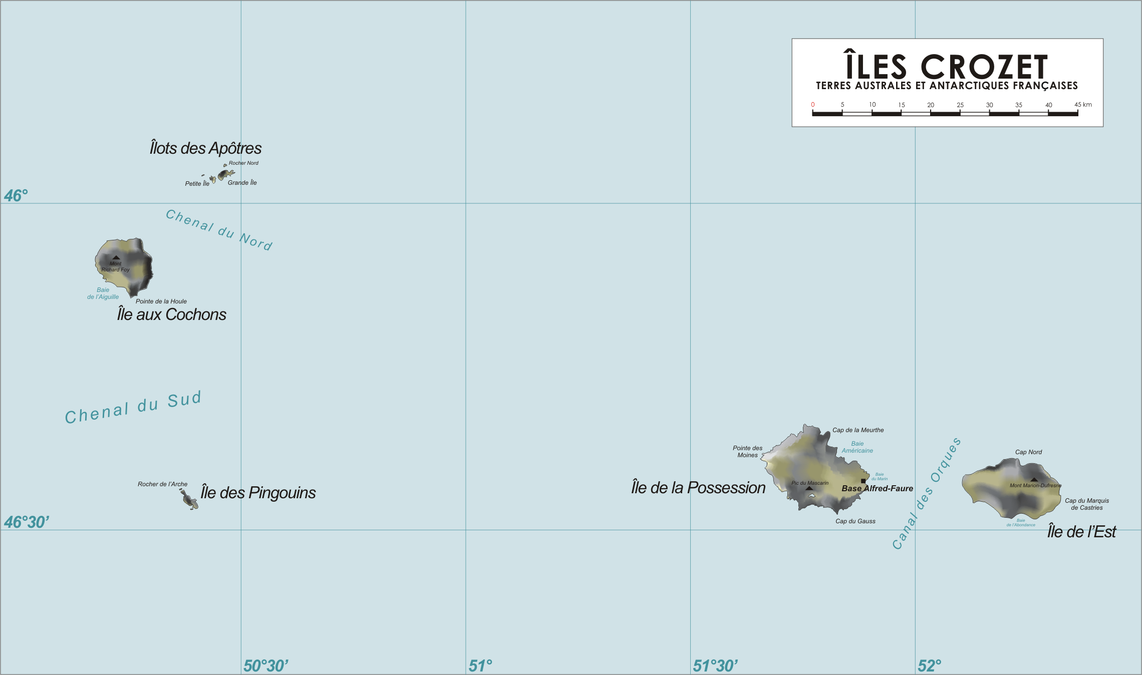
Map of the Crozet Islands, French Southern and Antarctic Territories
|
| Date | 13 April 2006 (original upload date) |
| Source | No machine-readable source provided. Own work assumed (based on copyright claims). |
| Author | No machine-readable author provided. Varp~commonswiki assumed (based on copyright claims). |
Licensing
| I, the copyright holder of this work, release this work into the public domain. This applies worldwide. In some countries this may not be legally possible; if so: I grant anyone the right to use this work for any purpose, without any conditions, unless such conditions are required by law. |
File history
Click on a date/time to view the file as it appeared at that time.
| Date/Time | Thumbnail | Dimensions | User | Comment | |
|---|---|---|---|---|---|
| current | 18:55, 13 April 2006 | | 2,280 × 1,348 (246 KB) | Varp~commonswiki | |
| 11:45, 13 April 2006 |  | 2,280 × 1,348 (242 KB) | Varp~commonswiki | *Map of the Crozet Islands, French Southern and Antarctic Territories *drawn by varp |
File usage
The following page uses this file:
Global file usage
The following other wikis use this file:
- Usage on af.wikipedia.org
- Usage on ar.wikipedia.org
- Usage on ast.wikipedia.org
- Usage on az.wikipedia.org
- Usage on bg.wikipedia.org
- Usage on br.wikipedia.org
- Usage on ca.wikipedia.org
- Usage on cs.wikipedia.org
- Usage on da.wikipedia.org
- Usage on de.wikipedia.org
- Usage on de.wikivoyage.org
- Usage on el.wikipedia.org
- Usage on en.wikipedia.org
- Usage on eo.wikipedia.org
- Usage on es.wikipedia.org
- Usage on eu.wikipedia.org
- Usage on fi.wikipedia.org
- Usage on fr.wikipedia.org
- Archipel Crozet
- Marc Joseph Marion du Fresne
- Île aux Cochons
- Île des Pingouins
- Îlots des Apôtres
- Île de la Possession
- Île de l'Est
- Base Alfred-Faure
- Terres australes et antarctiques françaises
- Mont Marion-Dufresne
- Pic du Mascarin
- Mont Richard-Foy
- Mont des Manchots
- Mont Pierre
- Julien Crozet
- Baie Américaine
- Tamaris (voilier)
- Lac Perdu (archipel Crozet)
- Vallée de l'Au-delà
- Guillaume Lesquin
- Jean-Pierre Majou
View more global usage of this file.