File:Deadhorse Alaska aerial view.jpg
Jump to navigation
Jump to search

Size of this preview: 800 × 481 pixels. Other resolutions: 320 × 192 pixels | 640 × 385 pixels | 1,024 × 616 pixels | 1,280 × 770 pixels | 1,866 × 1,122 pixels.
Original file (1,866 × 1,122 pixels, file size: 400 KB, MIME type: image/jpeg)
This is a file from the Wikimedia Commons and may be used by other projects. Information from its description page there is shown below.
Commons is a freely licensed media file repository. |
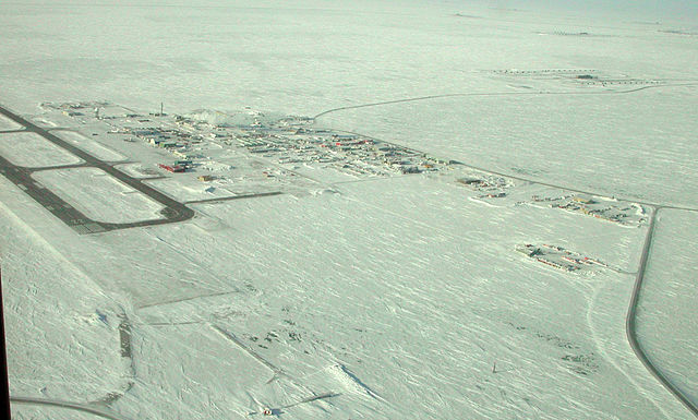
| Description |
English: PRUDHOE BAY-DEADHORSE, Alaska (March 12, 2007) – At the northern end of the Trans-Alaska Pipeline, Prudhoe Bay-Deadhorse, Alaska, also serves as the beach detachment for the Applied Physics Laboratory Ice Station (APLIS) which has been established on a drifting ice floe about 180 nautical miles north in support of arctic testing for U.S. and U.K submarines. |
||||||
| Date | Taken on 12 March 2007 | ||||||
| Source |
Navy NewsStand Photo ID: 070312-N-7179R-001 Navy NewsStand Home |
||||||
| Author | United States Navy, photographer not specified | ||||||
| Permission (Reusing this file) |
|
||||||

File history
Click on a date/time to view the file as it appeared at that time.
| Date/Time | Thumbnail | Dimensions | User | Comment | |
|---|---|---|---|---|---|
| current | 03:54, 18 February 2008 | | 1,866 × 1,122 (400 KB) | DanMS | {{Information |Description = {{en|PRUDHOE BAY-DEADHORSE, Alaska (March 12, 2007) – At the northern end of the Trans-Alaska Pipeline, Prudhoe Bay-Deadhorse, Alaska, also serves as the beach detachment for the Applied Physics Laboratory Ice Station (AP |
File usage
The following 4 pages use this file:
Global file usage
The following other wikis use this file:
- Usage on azb.wikipedia.org
- Usage on ce.wikipedia.org
- Usage on cy.wikipedia.org
- Usage on de.wikipedia.org
- Usage on en.wikipedia.org
- Usage on es.wikipedia.org
- Usage on fa.wikipedia.org
- Usage on fi.wikipedia.org
- Usage on fr.wikipedia.org
- Usage on hu.wikipedia.org
- Usage on id.wikipedia.org
- Usage on incubator.wikimedia.org
- Usage on it.wikipedia.org
- Usage on it.wikivoyage.org
- Usage on no.wikipedia.org
- Usage on pl.wikipedia.org
- Usage on ru.wikipedia.org
- Usage on sv.wikipedia.org
- Usage on tt.wikipedia.org
- Usage on uk.wikipedia.org
- Usage on www.wikidata.org
- Usage on zh.wikipedia.org