File:DonauknieVisegrad 2.jpg
Jump to navigation
Jump to search

Size of this preview: 797 × 115 pixels. Other resolutions: 320 × 46 pixels | 640 × 92 pixels | 1,024 × 148 pixels | 1,280 × 185 pixels | 2,560 × 370 pixels | 26,779 × 3,866 pixels.
Original file (26,779 × 3,866 pixels, file size: 24.54 MB, MIME type: image/jpeg)
This is a file from the Wikimedia Commons and may be used by other projects. Information from its description page there is shown below.
Commons is a freely licensed media file repository. |
| Warning | The original file is very high-resolution. It might not load properly or could cause your browser to freeze when opened at full size. |
|---|
Summary
| Description |
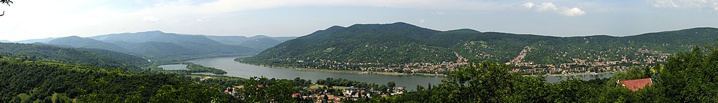
English: Danube Bend at Visegrád
Deutsch: Das Donauknie bei Visegrád |
| Date | |
| Source | picture taken by Philipp Weigell |
| Author | Myself |
| Other versions |
.jpg)
| Camera location | | View this and other nearby images on: OpenStreetMap |
|---|
Licensing
This file is licensed under the Creative Commons Attribution 3.0 Unported license.
- You are free:
- to share – to copy, distribute and transmit the work
- to remix – to adapt the work
- Under the following conditions:
- attribution – You must give appropriate credit, provide a link to the license, and indicate if changes were made. You may do so in any reasonable manner, but not in any way that suggests the licensor endorses you or your use.
File history
Click on a date/time to view the file as it appeared at that time.
| Date/Time | Thumbnail | Dimensions | User | Comment | |
|---|---|---|---|---|---|
| current | 17:07, 11 June 2011 | 26,779 × 3,866 (24.54 MB) | Morray | aufgehübscht | |
| 19:48, 6 June 2011 | 26,771 × 3,864 (19.21 MB) | Morray | {{Information |Description ={{en|1=Danube Bend at Visegrád}} {{de|1=Das Donauknie bei Visegrád}} |Source =picture taken by Philipp Weigell |Author =Myself |Date =June 2011 |Permission = |other_ver |
File usage
The following page uses this file:
Global file usage
The following other wikis use this file:
- Usage on as.wikipedia.org
- Usage on ba.wikipedia.org
- Usage on be.wikipedia.org
- Usage on bn.wikipedia.org
- Usage on cs.wikipedia.org
- Usage on de.wikipedia.org
- Usage on en.wikipedia.org
- Usage on eo.wikipedia.org
- Usage on eo.wikivoyage.org
- Usage on es.wikipedia.org
- Usage on et.wikipedia.org
- Usage on hyw.wikipedia.org
- Usage on it.wikivoyage.org
- Usage on ja.wikipedia.org
- Usage on mn.wikipedia.org
- Usage on nl.wikivoyage.org
- Usage on pl.wikipedia.org
- Usage on pl.wikivoyage.org
- Usage on ro.wikipedia.org
- Usage on ru.wikipedia.org
- Usage on sk.wikipedia.org
- Usage on sl.wikipedia.org
- Usage on te.wikipedia.org
- Usage on www.wikidata.org
- Usage on zh.wikipedia.org