File:Friskies Pinnacle Map.png
Jump to navigation
Jump to search

Size of this preview: 583 × 600 pixels. Other resolutions: 233 × 240 pixels | 466 × 480 pixels | 746 × 768 pixels | 995 × 1,024 pixels | 1,990 × 2,048 pixels | 2,899 × 2,983 pixels.
Original file (2,899 × 2,983 pixels, file size: 902 KB, MIME type: image/png)
This is a file from the Wikimedia Commons and may be used by other projects. Information from its description page there is shown below.
Commons is a freely licensed media file repository. |
Summary
| Description |
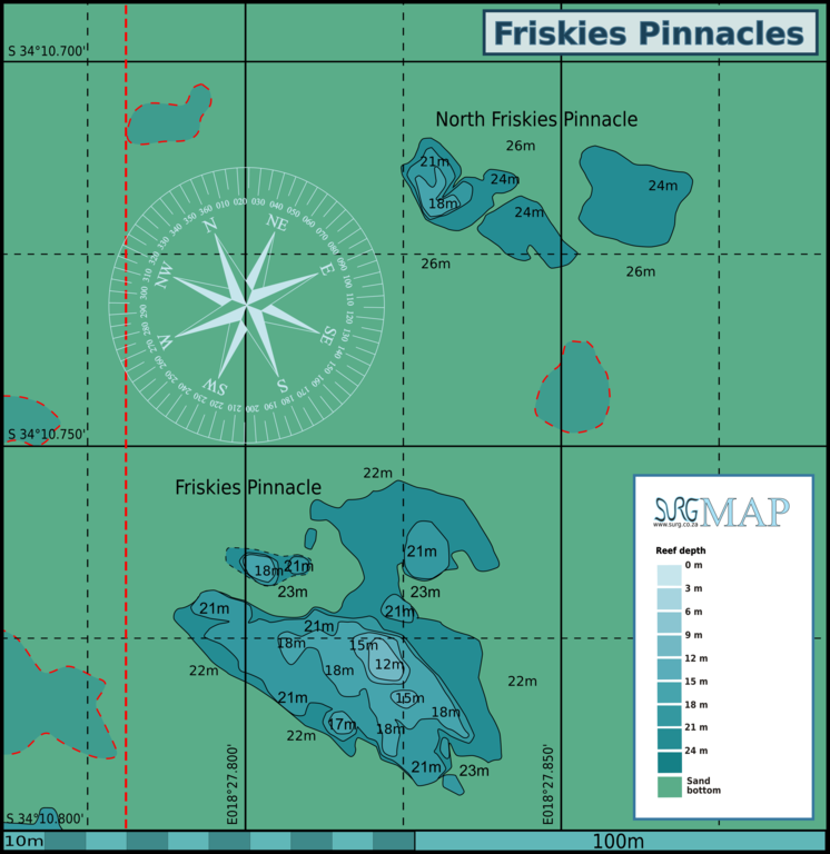
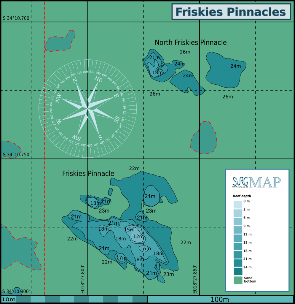
English: Map of the dive site "Friskies Pinnacle" at the Roman Rock reefs in Simon's Bay, Simon's Town, Cape Peninsula. |
| Date | |
| Source | Peter Southwood |
| Author | Peter Southwood |
Licensing
User: (WT-shared) Pbsouthwood at wts wikivoyage, the copyright holder of this work, hereby publishes it under the following license:
This file is licensed under the Creative Commons Attribution-Share Alike 3.0 Unported license.
Attribution: User: (WT-shared) Pbsouthwood at wts wikivoyage
- You are free:
- to share – to copy, distribute and transmit the work
- to remix – to adapt the work
- Under the following conditions:
- attribution – You must give appropriate credit, provide a link to the license, and indicate if changes were made. You may do so in any reasonable manner, but not in any way that suggests the licensor endorses you or your use.
- share alike – If you remix, transform, or build upon the material, you must distribute your contributions under the same or compatible license as the original.
Original upload log
| This file was imported from Wikivoyage WTS. |
The original description page was here. All following user names refer to wts.wikivoyage-old.
org:
- 2011-08-12 14:38 (WT-shared) Pbsouthwood[dead link] 2463×1870 (537544 bytes) {{Imagecredit|credit=Peter Southwood|captureDate=August 2011|location=Simon's Town, ape Peninsula|source=Peter Southwood|caption=Map of the (Import from wikitravel.org/shared)
- 2012-09-10 06:48 Pbsouthwood[dead link] 2463×1870 (549707 bytes) rm logo
File history
Click on a date/time to view the file as it appeared at that time.
| Date/Time | Thumbnail | Dimensions | User | Comment | |
|---|---|---|---|---|---|
| current | 10:26, 3 August 2021 | | 2,899 × 2,983 (902 KB) | Pbsouthwood | add 21m contour |
| 13:26, 12 June 2014 |  | 2,906 × 2,990 (972 KB) | Pbsouthwood | Updated with more depth annotations and cleaned up a bit | |
| 15:41, 6 September 2013 |  | 2,664 × 2,990 (732 KB) | Pbsouthwood | Added North Friskies | |
| 03:21, 13 December 2012 |  | 2,463 × 1,870 (537 KB) | OgreBot | (BOT): Reverting to most recent version before archival | |
| 03:20, 13 December 2012 |  | 2,463 × 1,870 (525 KB) | OgreBot | (BOT): Uploading old version of file from wts.wikivoyage; originally uploaded on 2011-08-12 14:38:39 by (WT-shared) Pbsouthwood | |
| 19:16, 15 November 2012 |  | 2,463 × 1,870 (537 KB) | MGA73bot2 | {{BotMoveToCommons|wts.oldwikivoyage|year={{subst:CURRENTYEAR}}|month={{subst:CURRENTMONTHNAME}}|day={{subst:CURRENTDAY}}}} == {{int:filedesc}} == {{Information |description=Map of the dive site "Friskies Pinnacle" at the Roman Rock reefs in Simon's Ba... |
File usage
The following 3 pages use this file: