File:Garden and grove outside the visitor center at Sunnylands, Rancho Mirage, California LCCN2013631268.tif
Original file (4,912 × 7,360 pixels, file size: 206.9 MB, MIME type: image/tiff)
This is a file from the Wikimedia Commons and may be used by other projects. Information from its description page there is shown below.
Commons is a freely licensed media file repository. |
Summary
DescriptionGarden and grove outside the visitor center at Sunnylands, Rancho Mirage, California LCCN2013631268.tif |
English: Title: Garden and grove outside the visitor center at Sunnylands, Rancho Mirage, California
Physical description: 1 photograph : digital, tiff file, color. Notes: Title, date, and keywords provided by the photographer.; Credit line: The Jon B. Lovelace Collection of California Photographs in Carol M. Highsmith's America Project, Library of Congress, Prints and Photographs Division.; Established by Walter and Leonore Annenberg as the headquarters of The Annenberg Foundation Trust at Sunnylands, the estate includes the Annenbergs' home, three guest cottages, 11 manmade lakes, and a private golf course.; Forms part of: Jon B. Lovelace Collection of California Photographs in Carol M. Highsmith's America Project in the Carol M. Highsmith Archive.; Gift; The Capital Group Companies Charitable Foundation in memory of Jon B. Lovelace; 2012; (DLC/PP-2012:063). |
||||||||||||||||||||||||||
Date | Taken on 20 January 2013, 16:40 (according to Exif data) | ||||||||||||||||||||||||||
Source |
Library of Congress
|
||||||||||||||||||||||||||
Author |
creator QS:P170,Q5044454 |
||||||||||||||||||||||||||
Permission (Reusing this file) |
No known restrictions on publication.
|
Camera location | 33° 46′ 48.85″ N, 116° 24′ 33.44″ W | View this and other nearby images on: OpenStreetMap | 33.780235; -116.409290 |
---|
Licensing
Public domainPublic domainfalsefalse |
This work is from the Carol M. Highsmith Archive collection at the Library of Congress. According to the library, there are no known copyright restrictions on the use of this work. Carol M. Highsmith has stipulated that her photographs are in the public domain. Photographs of sculpture or other works of art may be restricted by the copyright of the artist. |
Items portrayed in this file
depicts
2013
33°46'48.846"N, 116°24'33.444"W
File history
Click on a date/time to view the file as it appeared at that time.
Date/Time | Thumbnail | Dimensions | User | Comment | |
---|---|---|---|---|---|
current | 14:23, 2 September 2016 | 
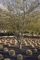
4,912 × 7,360 (206.9 MB) | Fæ | LOC 2013631268, Carol M. Highsmith collection. P132.7672 TIFF (206.9mb) |
File usage
The following page uses this file:
Metadata
This file contains additional information, probably added from the digital camera or scanner used to create or digitize it.
If the file has been modified from its original state, some details may not fully reflect the modified file.
Image title | Garden and grove outside the visitor center at Sunnylands, established by Walter and Leonore Annenberg on their estate in Rancho Mirage, California, as the headquarters of The Annenberg Foundation Trust at Sunnylands. The estate includes the Annenbergs' home, three guest cottages, 11 manmade lakes, and a private golf course. The Annenberg Trust developed programs focusing on improving civics education, developed and disseminated information on the treatment of adolescent mental disorders, increased communication among and impact of Annenberg-funded organizations, and held retreats to improve the functioning of democratic institutions. |
---|---|
Camera manufacturer | NIKON CORPORATION |
Camera model | NIKON D800E |
Author | Photographer: Carol M. Highsmith |
Exposure time | 1/80 sec (0.0125) |
F Number | f/10 |
ISO speed rating | 100 |
Date and time of data generation | 16:40, 20 January 2013 |
Lens focal length | 31 mm |
Latitude | 33° 46′ 48.85″ N |
Longitude | 116° 24′ 33.44″ W |
Altitude | 84 meters above sea level |
Width | 4,912 px |
Height | 7,360 px |
Bits per component |
|
Compression scheme | Uncompressed |
Pixel composition | RGB |
Image data location | 34,240 |
Orientation | Normal |
Number of components | 3 |
Number of rows per strip | 7,360 |
Bytes per compressed strip | 216,913,920 |
Horizontal resolution | 300 dpi |
Vertical resolution | 300 dpi |
Data arrangement | chunky format |
Software used | Ver.1.00 |
File change date and time | 14:56, 27 January 2013 |
Exposure Program | Manual |
Exif version | 2.21 |
Date and time of digitizing | 16:40, 20 January 2013 |
APEX shutter speed | 6.321928 |
APEX aperture | 6.643856 |
APEX exposure bias | −1.3333333333333 |
Maximum land aperture | 3 APEX (f/2.83) |
Metering mode | Pattern |
Light source | Unknown |
Flash | Flash did not fire, compulsory flash suppression |
DateTimeOriginal subseconds | 6 |
Color space | Uncalibrated |
Focal plane X resolution | 204.84020996094 |
Focal plane Y resolution | 204.84020996094 |
Focal plane resolution unit | 4 |
Sensing method | One-chip color area sensor |
File source | Digital still camera |
Scene type | A directly photographed image |
Custom image processing | Normal process |
Exposure mode | Manual exposure |
White balance | Auto white balance |
Digital zoom ratio | 1 |
Focal length in 35 mm film | 31 mm |
Scene capture type | Standard |
Scene control | None |
Contrast | Normal |
Saturation | Normal |
Sharpness | Normal |
Subject distance range | Unknown |
GPS time (atomic clock) | 23:40 |
Satellites used for measurement | 05 |
Geodetic survey data used | WGS 84 |
GPS date | 20 January 2013 |
GPS tag version | 2.3.0.0 |