File:Geographic Tyne and Wear Metro map.svg
Jump to navigation
Jump to search

Size of this PNG preview of this SVG file: 800 × 583 pixels. Other resolutions: 320 × 233 pixels | 640 × 466 pixels | 1,024 × 746 pixels | 1,280 × 932 pixels | 2,560 × 1,865 pixels | 1,149 × 837 pixels.
Original file (SVG file, nominally 1,149 × 837 pixels, file size: 21 KB)
This is a file from the Wikimedia Commons and may be used by other projects. Information from its description page there is shown below.
Commons is a freely licensed media file repository. |
| Description |
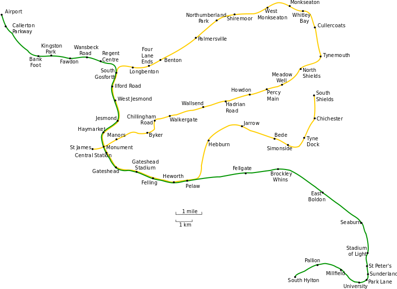
Geographically accurate map of the Tyne and Wear Metro system. t |
| Date | (UTC) |
| Source | |
| Author |
|
| This is a retouched picture, which means that it has been digitally altered from its original version. Modifications: Converted to SVG; used larger text font.. The original can be viewed here: Geographic Tyne and Wear Metro map.gif:
|
I, the copyright holder of this work, hereby publish it under the following license:

|
Permission is granted to copy, distribute and/or modify this document under the terms of the GNU Free Documentation License, Version 1.2 or any later version published by the Free Software Foundation; with no Invariant Sections, no Front-Cover Texts, and no Back-Cover Texts. A copy of the license is included in the section entitled GNU Free Documentation License. |
| This file is licensed under the Creative Commons Attribution-Share Alike 3.0 Unported license. | ||
| ||
| This licensing tag was added to this file as part of the GFDL licensing update. |
Original upload log
This image is a derivative work of the following images:
- File:Geographic_Tyne_and_Wear_Metro_map.gif licensed with GFDL
- 2007-07-16T02:55:27Z Responsible? 1189x844 (30138 Bytes) {{Information |Description=Geographically accurate map of the Tyne and Wear Metro system. |Source=Originally from [http://en.wikipedia.org en.wikipedia]; description page is/was [http://en.wikipedia.org/w/index.php?title=Imag
Uploaded with derivativeFX
File history
Click on a date/time to view the file as it appeared at that time.
| Date/Time | Thumbnail | Dimensions | User | Comment | |
|---|---|---|---|---|---|
| current | 10:37, 9 October 2010 | | 1,149 × 837 (21 KB) | Johnwalton | +Simonside, correct dot placement |
| 22:24, 17 December 2009 |  | 1,149 × 837 (54 KB) | Johnwalton | Reverted to version as of 16:27, 1 April 2009... dots are rendering misplaced | |
| 21:59, 17 December 2009 |  | 1,149 × 837 (44 KB) | Johnwalton | Added Simonside station. Minor update to some text spacing, and correct spelling of Whitley Bay. | |
| 16:27, 1 April 2009 |  | 1,149 × 837 (54 KB) | Aveekbh | {{Information |Description=Geographically accurate map of the Tyne and Wear Metro system. Inkscape-specific SVG, separated into layers for easy editing. |Source=*File:Geographic_Tyne_and_Wear_Metro_map.gif |Date=2009-04-01 17:26 (UTC) |Author=*[[:Fi | |
| 14:01, 1 April 2009 |  | 1,149 × 837 (49 KB) | Aveekbh | {{Information |Description=Geographically accurate map of the Tyne and Wear Metro system. t |Source=*File:Geographic_Tyne_and_Wear_Metro_map.gif |Date=2009-04-01 14:59 (UTC) |Author=*File:Geographic_Tyne_and_Wear_Metro_map.gif: Original upload |
File usage
There are no pages that use this file.
Global file usage
The following other wikis use this file:
- Usage on af.wikipedia.org
- Usage on ca.wikipedia.org
- Usage on de.wikipedia.org
- Usage on de.wikivoyage.org
- Usage on en.wikipedia.org
- Usage on es.wikipedia.org
- Usage on eu.wikipedia.org
- Usage on fa.wikipedia.org
- Usage on fi.wikipedia.org
- Usage on hu.wikipedia.org
- Usage on hy.wikipedia.org
- Usage on it.wikipedia.org
- Usage on ja.wikipedia.org
- Usage on ms.wikipedia.org
- Usage on pl.wikipedia.org
- Usage on tr.wikipedia.org
- Usage on www.wikidata.org