File:Harriet Tubman Locations Map.jpg
Jump to navigation
Jump to search
No higher resolution available.
Harriet_Tubman_Locations_Map.jpg (446 × 383 pixels, file size: 98 KB, MIME type: image/jpeg)
This is a file from the Wikimedia Commons and may be used by other projects. Information from its description page there is shown below.
Commons is a freely licensed media file repository. |
Summary
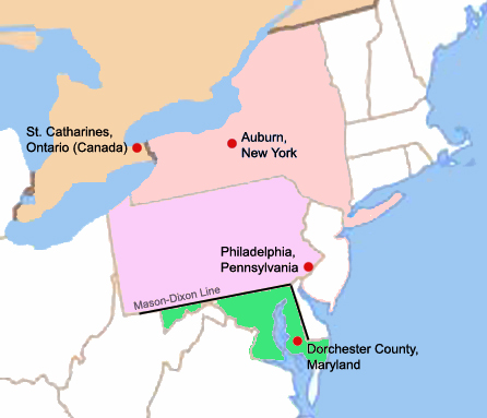
| Description | A map of four key locations in the life of Harriet Tubman |
| Date | |
| Source | Own work |
| Author | Scartol |
Licensing
| I, the copyright holder of this work, release this work into the public domain. This applies worldwide. In some countries this may not be legally possible; if so: I grant anyone the right to use this work for any purpose, without any conditions, unless such conditions are required by law. |

|
This historical map image could be re-created using vector graphics as an SVG file. This has several advantages; see Commons:Media for cleanup for more information. If an SVG form of this image is available, please upload it and afterwards replace this template with
{{vector version available|new image name}}.
It is recommended to name the SVG file “Harriet Tubman Locations Map.svg”—then the template Vector version available (or Vva) does not need the new image name parameter. |


File history
Click on a date/time to view the file as it appeared at that time.
| Date/Time | Thumbnail | Dimensions | User | Comment | |
|---|---|---|---|---|---|
| current | 01:07, 29 April 2023 | | 446 × 383 (98 KB) | Hohum | Reworked colours for clarity |
| 03:10, 16 November 2007 |  | 446 × 383 (106 KB) | Scartol | {{Information |Description=A map of four key locations in the life of Harriet Tubman |Source=self-made |Date=15 November 2007 |Author= Scartol |Permission= |other_versions= }} |
File usage
There are no pages that use this file.
Global file usage
The following other wikis use this file:
- Usage on bcl.wikipedia.org
- Usage on ca.wikipedia.org
- Usage on de.wikipedia.org
- Usage on el.wikipedia.org
- Usage on en.wikipedia.org
- Usage on fr.wikipedia.org
- Usage on ko.wikipedia.org
- Usage on nn.wikipedia.org
- Usage on tl.wikipedia.org