File:Map of Danish Settlements in India (1620 - 1845).svg
Jump to navigation
Jump to search

Size of this PNG preview of this SVG file: 512 × 446 pixels. Other resolutions: 276 × 240 pixels | 551 × 480 pixels | 882 × 768 pixels | 1,176 × 1,024 pixels | 2,351 × 2,048 pixels.
Original file (SVG file, nominally 512 × 446 pixels, file size: 162 KB)
This is a file from the Wikimedia Commons and may be used by other projects. Information from its description page there is shown below.
Commons is a freely licensed media file repository. |
.svg)
Summary
| Description |
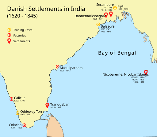
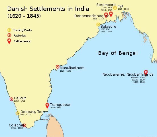
English: Map of Danish settlements and trading posts in India from 1620 - 1845 |
| Date | |
| Source | Created using illustrator |
| Author | Adondai |
| This file is made available under the Creative Commons CC0 1.0 Universal Public Domain Dedication. | |
| The person who associated a work with this deed has dedicated the work to the public domain by waiving all of their rights to the work worldwide under copyright law, including all related and neighboring rights, to the extent allowed by law. You can copy, modify, distribute and perform the work, even for commercial purposes, all without asking permission.
|
Licensing
| I, the copyright holder of this work, release this work into the public domain. This applies worldwide. In some countries this may not be legally possible; if so: I grant anyone the right to use this work for any purpose, without any conditions, unless such conditions are required by law. |
File history
Click on a date/time to view the file as it appeared at that time.
| Date/Time | Thumbnail | Dimensions | User | Comment | |
|---|---|---|---|---|---|
| current | 09:07, 7 May 2018 | | 512 × 446 (162 KB) | Adondai | {{subst:Upload marker added by en.wp UW}} {{Information |Description = {{en|Map of Danish settlements and trading posts in India from 1620 - 1845}} |Source = Created using illustrator |Date = 2018-05-07 |Author = Adondai }} {{cc-zero}} |
File usage
The following page uses this file:
Global file usage
The following other wikis use this file:
- Usage on ar.wikipedia.org
- Usage on bn.wikipedia.org
- Usage on de.wikipedia.org
- Usage on en.wikipedia.org
- Usage on es.wikipedia.org
- Usage on fr.wikipedia.org
- Usage on he.wikipedia.org
- Usage on id.wikipedia.org
- Usage on it.wikipedia.org
- Usage on ja.wikipedia.org
- Usage on mt.wikipedia.org
- Usage on nl.wikipedia.org
- Usage on vi.wikipedia.org
- Usage on www.wikidata.org
- Usage on wuu.wikipedia.org
- Usage on zh.wikipedia.org
.svg)