File:Masirah.jpg
Jump to navigation
Jump to search

Size of this preview: 503 × 599 pixels. Other resolutions: 201 × 240 pixels | 403 × 480 pixels | 996 × 1,186 pixels.
Original file (996 × 1,186 pixels, file size: 751 KB, MIME type: image/jpeg)
This is a file from the Wikimedia Commons and may be used by other projects. Information from its description page there is shown below.
Commons is a freely licensed media file repository. |
Summary
| Description |
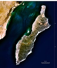
English: Satellite Image of Masirah Island, Oman |
| Date | 2000s |
| Source | NASA World Wind screen shot |
| Author | NASA |
Licensing
| This image is in the public domain because it is a screenshot from NASA’s globe software World Wind using a public domain layer, such as Blue Marble, MODIS, Landsat, SRTM, USGS or GLOBE.
|
 |
File history
Click on a date/time to view the file as it appeared at that time.
| Date/Time | Thumbnail | Dimensions | User | Comment | |
|---|---|---|---|---|---|
| current | 21:13, 24 August 2010 | | 996 × 1,186 (751 KB) | Ratzer | {{Information |Description={{en|1=Satellite Image of Masirah Island, Oman}} |Source=NASA World Wind screen shot |Author=NASA |Date=2000s |Permission= |other_versions= }} Category:Satellite pictures of Oman Category:Masirah Island |
File usage
The following 2 pages use this file:
Global file usage
The following other wikis use this file:
- Usage on ar.wikipedia.org
- Usage on arz.wikipedia.org
- Usage on ca.wikipedia.org
- Usage on ceb.wikipedia.org
- Usage on de.wikipedia.org
- Usage on en.wikipedia.org
- Usage on es.wikipedia.org
- Usage on fi.wikipedia.org
- Usage on fr.wikipedia.org
- Usage on gl.wikipedia.org
- Usage on he.wikivoyage.org
- Usage on hu.wikipedia.org
- Usage on it.wikipedia.org
- Usage on it.wikivoyage.org
- Usage on ja.wikipedia.org
- Usage on nn.wikipedia.org
- Usage on no.wikipedia.org
- Usage on pl.wikipedia.org
- Usage on uk.wikipedia.org
- Usage on ur.wikipedia.org
- Usage on www.wikidata.org
- Usage on zh.wikipedia.org