File:Mughal Historical Map.png
Jump to navigation
Jump to search
Size of this preview: 562 × 600 pixels. Other resolutions: 225 × 240 pixels | 450 × 480 pixels.
Original file (800 × 854 pixels, file size: 1.26 MB, MIME type: image/png)
This is a file from the Wikimedia Commons and may be used by other projects. Information from its description page there is shown below.
Commons is a freely licensed media file repository. |
Summary
| Description |
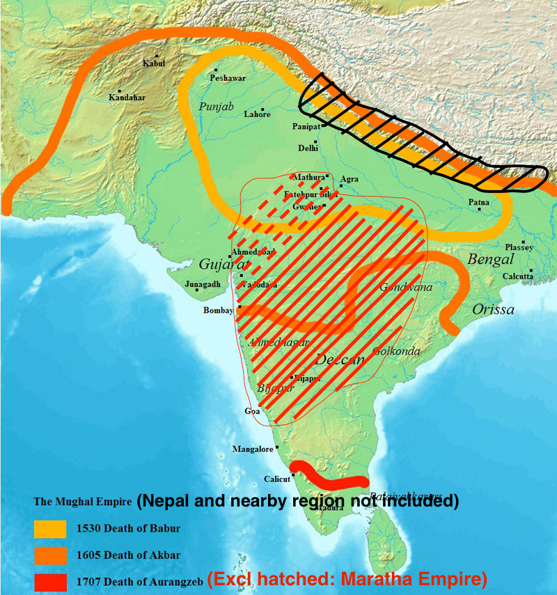
Historical map of the Mughal empire uploaded fra en:wikipedia with identical license |
| Source | Self made by (Javierfv1212) |
| Author | User:Moeng |
| Other versions | العربيَّة |
Licensing
| I, the copyright holder of this work, release this work into the public domain. This applies worldwide. In some countries this may not be legally possible; if so: I grant anyone the right to use this work for any purpose, without any conditions, unless such conditions are required by law. |
File history
Click on a date/time to view the file as it appeared at that time.
| Date/Time | Thumbnail | Dimensions | User | Comment | |
|---|---|---|---|---|---|
| current | 17:22, 2 April 2017 | | 800 × 854 (1.26 MB) | Ms Sarah Welch | convert a very inaccurate map with a bit more accurate map, see discussion and comments on talk page and per suggestion at admin @Yann's talk page |
| 22:17, 6 March 2008 |  | 800 × 854 (996 KB) | Moeng | {{Information |Description=Historical map of the Mughal empire |Source=Self made |Date= |Author=en:User:Javierfv1212 |Permission= |other_versions= }} |
File usage
The following page uses this file:
Global file usage
The following other wikis use this file:
- Usage on ar.wikipedia.org
- Usage on ba.wikipedia.org
- Usage on be-tarask.wikipedia.org
- Usage on be.wikipedia.org
- Usage on bg.wikipedia.org
- Usage on bh.wikipedia.org
- Usage on bn.wikipedia.org
- Usage on br.wikipedia.org
- Usage on ca.wikipedia.org
- Usage on da.wikipedia.org
- Usage on el.wikipedia.org
- Usage on et.wikipedia.org
- Usage on fiu-vro.wikipedia.org
- Usage on gom.wikipedia.org
- Usage on gu.wikipedia.org
- Usage on hak.wikipedia.org
- Usage on hi.wikibooks.org
- Usage on it.wikivoyage.org
- Usage on ja.wikipedia.org
- Usage on ka.wikipedia.org
- Usage on kk.wikipedia.org
- Usage on kn.wikipedia.org
- Usage on lt.wikipedia.org
- Usage on mk.wikipedia.org
- Usage on ml.wikipedia.org
- Usage on mr.wikipedia.org
- Usage on sq.wikipedia.org
- Usage on sr.wikipedia.org
- Usage on tl.wikipedia.org
- Usage on tt.wikipedia.org
- Usage on uk.wikipedia.org
- Usage on ur.wikipedia.org
- Usage on vi.wikipedia.org
- Usage on wuu.wikipedia.org
- Usage on xmf.wikipedia.org
- Usage on zh-yue.wikipedia.org