File:Mumbai suburban rail map.svg
Jump to navigation
Jump to search

Size of this PNG preview of this SVG file: 588 × 600 pixels. Other resolutions: 235 × 240 pixels | 471 × 480 pixels | 753 × 768 pixels | 1,004 × 1,024 pixels | 2,008 × 2,048 pixels | 2,492 × 2,541 pixels.
Original file (SVG file, nominally 2,492 × 2,541 pixels, file size: 149 KB)
This is a file from the Wikimedia Commons and may be used by other projects. Information from its description page there is shown below.
Commons is a freely licensed media file repository. |
Summary
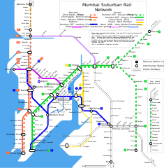
| Description | Schematic map of the Mumbai suburban rail network. | ||
| Date | |||
| Source | Drawn | ||
| Author |
|
Licensing
I, the copyright holder of this work, hereby publish it under the following license:
This file is licensed under the Creative Commons Attribution-Share Alike 2.5 Generic license.
- You are free:
- to share – to copy, distribute and transmit the work
- to remix – to adapt the work
- Under the following conditions:
- attribution – You must give appropriate credit, provide a link to the license, and indicate if changes were made. You may do so in any reasonable manner, but not in any way that suggests the licensor endorses you or your use.
- share alike – If you remix, transform, or build upon the material, you must distribute your contributions under the same or compatible license as the original.
File history
Click on a date/time to view the file as it appeared at that time.
| Date/Time | Thumbnail | Dimensions | User | Comment | |
|---|---|---|---|---|---|
| current | 19:33, 14 June 2014 | | 2,492 × 2,541 (149 KB) | RaviC | Update. Metro (sans airport) completed, add in monorail line |
| 13:22, 12 July 2006 |  | 2,492 × 2,541 (113 KB) | Planemad | viewing problem | |
| 16:23, 1 June 2006 |  | 2,492 × 2,548 (117 KB) | Planemad | ||
| 14:51, 31 May 2006 |  | 2,492 × 2,547 (117 KB) | Planemad | Reverted to earlier revision | |
| 14:49, 31 May 2006 |  | 2,318 × 2,534 (156 KB) | Planemad | Reverted to earlier revision | |
| 14:47, 31 May 2006 |  | 2,492 × 2,547 (117 KB) | Planemad | display error | |
| 13:53, 31 May 2006 |  | 2,483 × 2,547 (117 KB) | Planemad | ||
| 05:41, 31 May 2006 |  | 2,483 × 2,547 (128 KB) | Planemad | overhauled | |
| 12:58, 29 May 2006 |  | 2,318 × 2,534 (156 KB) | Planemad | {{Information| |Description=Schematic map of the Mumbai suburban rail network. |Source=Drawn |Date=29 May 2006 |Author= w:user:PlaneMad |Permission=n/a |other_versions= }} Category:Mumbai Category:Rapid transit maps |
File usage
There are no pages that use this file.
Global file usage
The following other wikis use this file:
- Usage on ca.wikipedia.org
- Usage on en.wikipedia.org
- Usage on ga.wikipedia.org
- Usage on gl.wikipedia.org
- Usage on pl.wikinews.org
- Usage on tg.wikipedia.org
- Usage on www.wikidata.org