File:Norangsdalen.jpg
Jump to navigation
Jump to search

Size of this preview: 452 × 599 pixels. Other resolutions: 181 × 240 pixels | 362 × 480 pixels | 580 × 768 pixels | 1,232 × 1,632 pixels.
Original file (1,232 × 1,632 pixels, file size: 669 KB, MIME type: image/jpeg)
This is a file from the Wikimedia Commons and may be used by other projects. Information from its description page there is shown below.
Commons is a freely licensed media file repository. |
| Description |
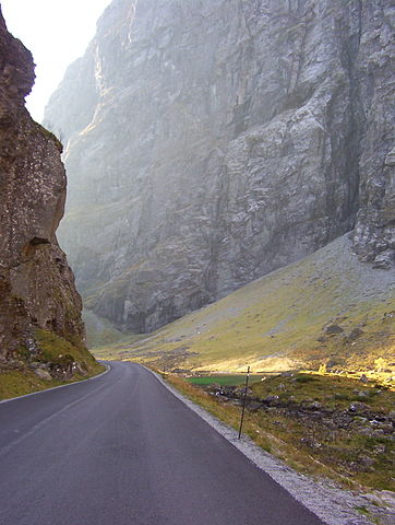
English: Riksvei 655 in Norangsdalen in Ørsta, Norway. Original description: The end of the road? No it just bends through Northern Europe's most narrow ravine, in Norangdal, Ørsta. Situated in the middle of Sunnmørsalpane. During the winter the sun never reaches and avalanches from both sides of the ravine will close the road often. Picture taken in October 2004 with my old compact camera, a lucky catch of some of the last sunrays that year! It remains one of my all time favorites!
Esperanto: Nacia vojo 655 en Norangsdalen en norvegio. Originala priskribo: Ĉu la fino de la vojo? Ne, ĝi nur serpentumas trans la plej malvasta ravino en norda eŭropo, en Norangdal, Ørsta. Dum la vintro la suno neniam atingas la lokon, kaj rokfaloj de ambaŭ flankoj de la ravino ofte fermas la vojon. Bildo fotata en oktobro 2004 kun mia malnova malgranda fotografilo. Mi bonŝance kaptis la lastajn sunradiojn de tiu jaro! Ĝi restas unu el miaj plej ŝatataj fotoj. |
| Date | |
| Source | Home Free : Norangdal |
| Author | Fairy Heart |
| Camera location | | View this and other nearby images on: OpenStreetMap |
|---|
Licensing
This file is licensed under the Creative Commons Attribution-Share Alike 2.0 Generic license.
- You are free:
- to share – to copy, distribute and transmit the work
- to remix – to adapt the work
- Under the following conditions:
- attribution – You must give appropriate credit, provide a link to the license, and indicate if changes were made. You may do so in any reasonable manner, but not in any way that suggests the licensor endorses you or your use.
- share alike – If you remix, transform, or build upon the material, you must distribute your contributions under the same or compatible license as the original.
| This image was originally posted to Flickr by Fairy Heart at https://www.flickr.com/photos/35888870@N07/4112627641. It was reviewed on 21 December 2009 by FlickreviewR and was confirmed to be licensed under the terms of the cc-by-sa-2.0. |
File history
Click on a date/time to view the file as it appeared at that time.
| Date/Time | Thumbnail | Dimensions | User | Comment | |
|---|---|---|---|---|---|
| current | 23:23, 20 December 2009 | | 1,232 × 1,632 (669 KB) | Blue Elf | {{Information |Description=Riksvei 655 in Norangsdalen in Ørsta, Norway. Original description: The end of the road? No it just bends through Northern Europe's most narrow ravine, in Norangdal, Ørsta. Situated in the middle of Sunnmørsalpane. During the |
File usage
The following 2 pages use this file:
Global file usage
The following other wikis use this file:
- Usage on fi.wikipedia.org
- Usage on it.wikivoyage.org
- Usage on nn.wikipedia.org
- Usage on no.wikipedia.org
- Usage on www.wikidata.org