File:HighwaysMapPoland.svg
Jump to navigation
Jump to search

Size of this PNG preview of this SVG file: 643 × 599 pixels. Other resolutions: 258 × 240 pixels | 515 × 480 pixels | 824 × 768 pixels | 1,099 × 1,024 pixels | 2,198 × 2,048 pixels | 776 × 723 pixels.
Original file (SVG file, nominally 776 × 723 pixels, file size: 359 KB)
This is a file from the Wikimedia Commons and may be used by other projects. Information from its description page there is shown below.
Commons is a freely licensed media file repository. |
Summary
| Description |
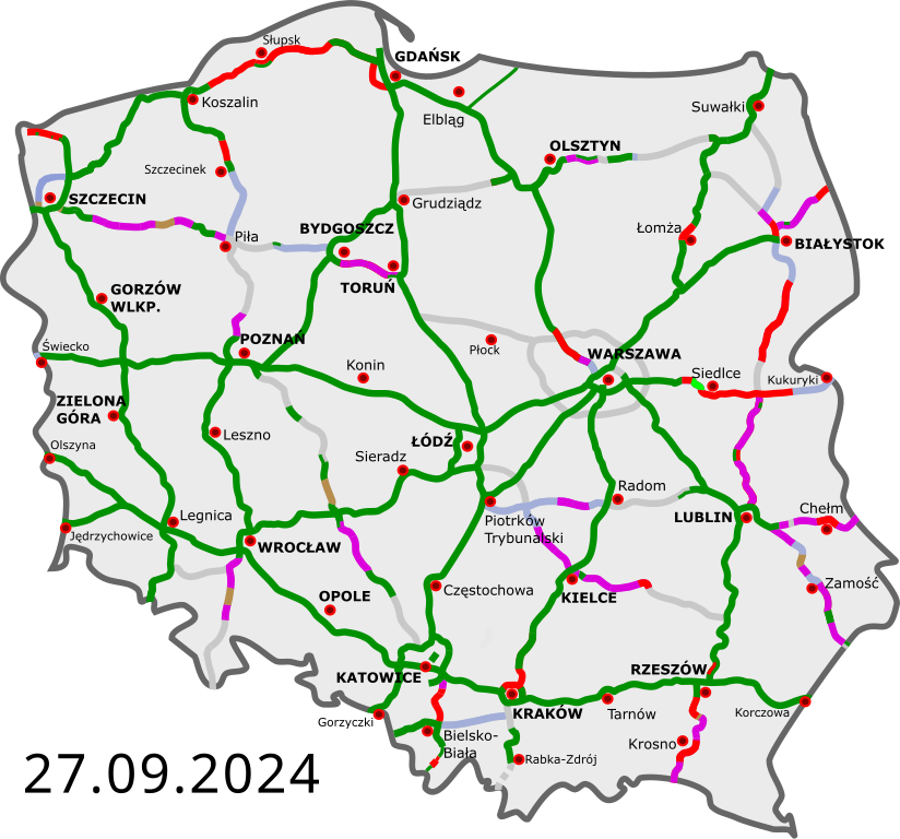
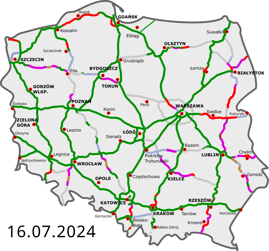
Polski: Polskie autostrady i drogi ekspresowe:
istniejące przejezdne (na zasadzie tymczasowej organizacji ruchu) w budowie umowa „projektuj i buduj”; etap projektowania w przetargu wydana decyzja środowiskowa planowane English: Polish freeways:
Completed Opened, some works continue Construction Design-build contract (design phase) Tender Environmental permit issued Planned Deutsch: polnische Autobahnen und Schnellstraßen:
fertiggestellt geöffnet, einige Arbeiten gehen weiter im Bau Entwurfs- und Bauvertrag, Entwurfsphase in der Ausschreibung Umweltverträglichkeitsprüfung geplant Čeština: Polské dálnice a rychlostní silnice:
v provozu ve stavbě plánované Esperanto: Polaj aŭtovojoj kaj rapidvojoj:
kompletigitaj malfermitaj, kelkaj laboroj daŭras konstruataj skizo kaj konstrukontrakto, projektfazo ofertataj al konstrufirmaoj planitaj Español: Autopistas y autovias polacas:
abiertas en construcción en proyecto Français : Les autoroutes polonaises:
existantes en construction en projet Magyar: Lengyelország autópályái:
kész szakasz épülő szakasz tervezett szakasz Italiano: Autostrade polacche: aperte al traffico in costruzione progettate |
||
| Date | |||
| Source | |||
| Author |
|
||
| Other versions | Derivative works of this file: Historia budowy autostrad i dróg ekspresowych.gif | ||
| SVG development |
|
Licensing
I, the copyright holder of this work, hereby publish it under the following licenses:
This file is licensed under the Creative Commons Attribution 3.0 Unported license.
- You are free:
- to share – to copy, distribute and transmit the work
- to remix – to adapt the work
- Under the following conditions:
- attribution – You must give appropriate credit, provide a link to the license, and indicate if changes were made. You may do so in any reasonable manner, but not in any way that suggests the licensor endorses you or your use.
You may select the license of your choice.
Original upload log
This image is a derivative work of the following images:
- DocelowyUkladDrog.svg licensed with Cc-by-3.0, Cc-by-3.0
- 2009-08-30T16:41:32Z Sliwers 784x723 (155471 Bytes) Darker color.
- 2009-08-30T16:40:18Z Sliwers 784x723 (155471 Bytes) Cropped.
- 2009-08-30T16:36:58Z Sliwers 1073x790 (154212 Bytes) {{Information |Description={{en|1=Map of the planned free- and expressway network in Poland.}} {{pl|1=Docelowy układ autostrad i dróg ekspresowych w Polsce.}} {{de|1=Das Autobahn- und Schnellstraßennetz Polens, geplanter E
Uploaded with derivativeFX
File history
Click on a date/time to view the file as it appeared at that time.
| Date/Time | Thumbnail | Dimensions | User | Comment | |
|---|---|---|---|---|---|
| current | 18:35, 17 April 2024 | | 776 × 723 (359 KB) | Docxent | umowa na proj. i budowę drugiej jezdni obw. Kępna w ciągu drogi S11 |
| 17:00, 16 April 2024 |  | 776 × 723 (359 KB) | Docxent | ZRID dla rozbudowy odcinka S19 Sokołów Małopolski Płn. - Jasionka | |
| 13:17, 28 March 2024 |  | 776 × 723 (359 KB) | Docxent | umowa na proj. i budowę S11 Kępno - Siemianice | |
| 12:43, 28 March 2024 |  | 776 × 723 (359 KB) | Docxent | Podpisanie umowy na zaprojektowanie i wybudowanie odc. S74 Cedzyna - Łagów | |
| 22:47, 23 March 2024 |  | 776 × 723 (359 KB) | Docxent | S7 Lesznowola stała org. Ruchu | |
| 22:49, 28 February 2024 |  | 776 × 723 (360 KB) | Docxent | wydanie ZRID na drogę S19 w rejonie Białegostoku | |
| 22:10, 19 February 2024 |  | 776 × 723 (360 KB) | Docxent | Umowa na projekt i budowę S19 od Czarnej Białostockiej do węzła Białystok Północ | |
| 20:33, 5 February 2024 |  | 776 × 723 (360 KB) | Docxent | wydanie DSU na odc. S17 Łopiennik (bez węzła) - Krasnystaw Północ (bez węzła) | |
| 22:43, 30 January 2024 |  | 776 × 723 (359 KB) | Docxent | wydano ZRID dla odcinka S19 Malewice – Chlebczyn | |
| 10:11, 30 December 2023 |  | 776 × 723 (359 KB) | Docxent | Nowy przetarg dla S8 |
File usage
The following 2 pages use this file:
Global file usage
The following other wikis use this file:
- Usage on bg.wikipedia.org
- Usage on cs.wikipedia.org
- Usage on de.wikipedia.org
- Usage on de.wikivoyage.org
- Usage on en.wikipedia.org
- Usage on eo.wikipedia.org
- Usage on eo.wikivoyage.org
- Usage on es.wikivoyage.org
- Usage on fi.wikipedia.org
- Usage on fr.wikipedia.org
- Usage on fr.wikivoyage.org
- Usage on he.wikivoyage.org
- Usage on hu.wikipedia.org
- Usage on it.wikipedia.org
- Usage on it.wikivoyage.org
- Usage on ja.wikipedia.org
- Usage on nl.wikipedia.org
- Usage on nl.wikivoyage.org
- Usage on pl.wikipedia.org
- Usage on pl.wikivoyage.org
- Usage on pt.wikivoyage.org
- Usage on ro.wikipedia.org
- Usage on ro.wikivoyage.org
- Usage on ru.wikipedia.org
- Usage on ru.wikivoyage.org
- Usage on sh.wikipedia.org
- Usage on sr.wikipedia.org
- Usage on sv.wikipedia.org
- Usage on sv.wikivoyage.org
- Usage on tr.wikipedia.org
- Usage on uk.wikipedia.org
- Usage on vi.wikipedia.org