File:Railway map of Macedonia.png
Jump to navigation
Jump to search
Size of this preview: 778 × 600 pixels. Other resolutions: 312 × 240 pixels | 623 × 480 pixels | 997 × 768 pixels | 1,280 × 987 pixels | 1,732 × 1,335 pixels.
Original file (1,732 × 1,335 pixels, file size: 256 KB, MIME type: image/png)
This is a file from the Wikimedia Commons and may be used by other projects. Information from its description page there is shown below.
Commons is a freely licensed media file repository. |
| Description |
|
| Date | |
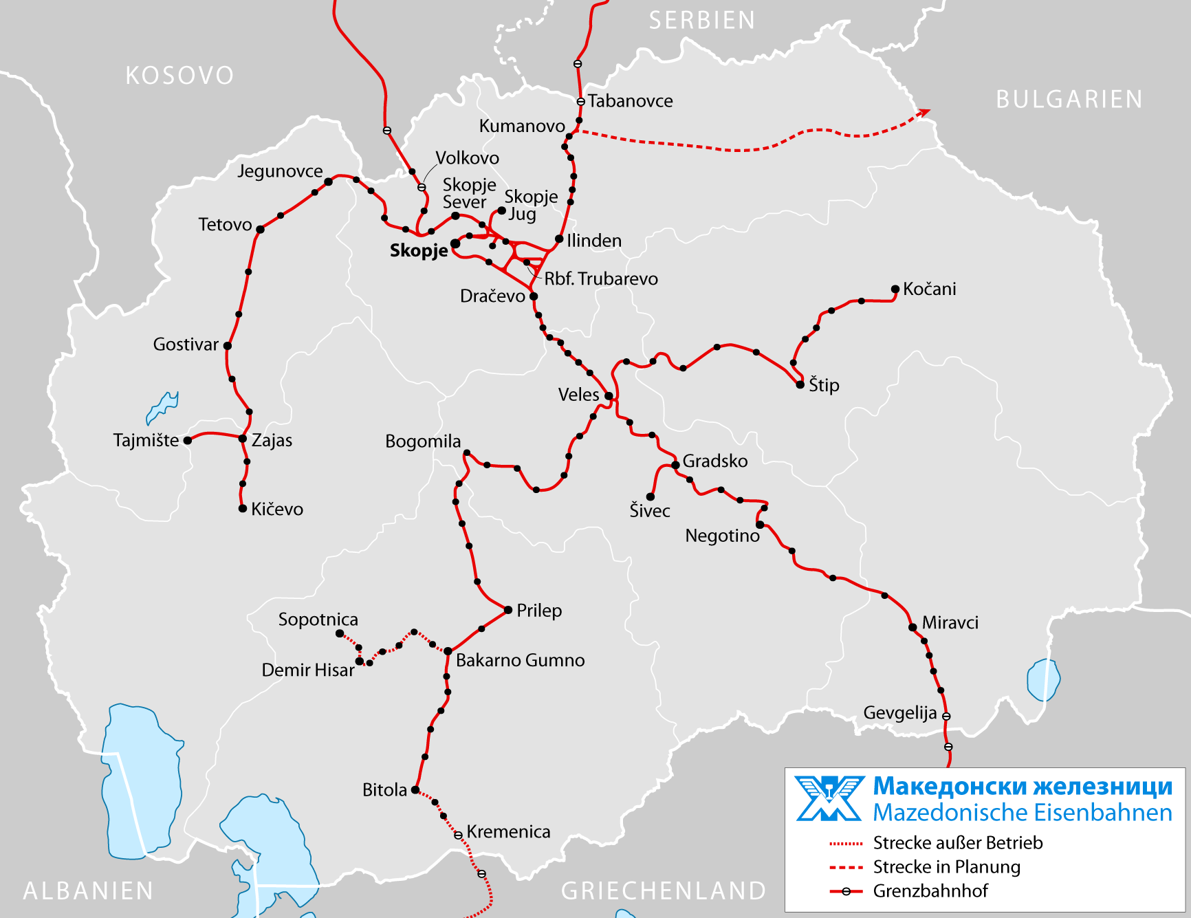
| Source |
own work, using |
| Author | Maximilian Dörrbecker (Chumwa) |
| Permission (Reusing this file) |
I, the copyright holder of this work, hereby publish it under the following license: This file is licensed under the Creative Commons Attribution-Share Alike 2.5 Generic license.
Sie dürfen das Bild zu den folgenden Bedingungen nutzen:
|
File history
Click on a date/time to view the file as it appeared at that time.
| Date/Time | Thumbnail | Dimensions | User | Comment | |
|---|---|---|---|---|---|
| current | 19:26, 16 September 2009 | | 1,732 × 1,335 (256 KB) | Chumwa | Flagge als Hintergrund herausgenommen, Trubarevo vom Gbf in einen Rbf umgewandelt |
| 22:33, 15 September 2009 |  | 1,732 × 1,335 (297 KB) | Chumwa | {{Information |Description= *{{ de }} Karte des Bahnnetzes von Mazedonien *{{ en }} Railway map of Macedonia *{{ mk }} Македонски железници |Date=2009-09 |Author= Maximilian Dörrbecker (Chumwa) | |
File usage
The following page uses this file:
Global file usage
The following other wikis use this file:
- Usage on bg.wikipedia.org
- Usage on cs.wikipedia.org
- Usage on de.wikipedia.org
- Usage on de.wikivoyage.org
- Usage on en.wikipedia.org
- Usage on fa.wikipedia.org
- Usage on fr.wikipedia.org
- Usage on fr.wikivoyage.org
- Usage on hu.wikipedia.org
- Usage on it.wikipedia.org
- Usage on it.wikivoyage.org
- Usage on ja.wikipedia.org
- Usage on lv.wikipedia.org
- Usage on mk.wikipedia.org
- ЖС „Миравци“
- ЖС „Неготино Вардар“
- ЖС „Никола Карев“
- ЖС „Браилово“
- ЖС „Даме Груев“
- ЖС „Битола“
- ЖС „Лознани“
- ЖС „Новоселани“
- ЖС „Тројкрсти“
- ЖС „Бакарно Гумно“
- ЖС „Галичани“
- ЖС „Прилеп“
- ЖС „Сенокос“
- ЖС „Слепче“
- ЖС „Гостиражни“
- ЖС „Богомила“
- ЖС „Теово“
- ЖС „Мартолци“
- ЖС „Чашка“
- ЖС „Лисиче“
- Шаблон:Железнички станици на линијата Скопје-Гевгелија
- Шаблон:Железнички станици на линијата Скопје-Битола
- ЖС „Васил Антевски - Дрен“
- Usage on no.wikipedia.org
- Usage on pl.wikipedia.org
- Usage on ro.wikipedia.org
- Usage on sq.wikipedia.org
- Usage on sr.wikipedia.org
- Usage on sv.wikipedia.org
- Usage on uk.wikipedia.org
View more global usage of this file.