File:Rapid transit map of Mumbai.jpg
Jump to navigation
Jump to search

Size of this preview: 391 × 600 pixels. Other resolutions: 156 × 240 pixels | 313 × 480 pixels | 501 × 768 pixels | 668 × 1,024 pixels | 1,336 × 2,048 pixels | 4,150 × 6,363 pixels.
Original file (4,150 × 6,363 pixels, file size: 5.82 MB, MIME type: image/jpeg)
This is a file from the Wikimedia Commons and may be used by other projects. Information from its description page there is shown below.
Commons is a freely licensed media file repository. |
Summary
| Description |
|
| Date | see file history |
| Source | Own work using: OpenStreetMap data for the background |
| Author | Maximilian Dörrbecker (Chumwa) |
| Permission (Reusing this file) |
All OpenStreetMap data and maps are Creative Commons "CC-BY-SA 2.0" licensed This file is licensed under the Creative Commons Attribution-Share Alike 2.0 Generic license.
|
File history
Click on a date/time to view the file as it appeared at that time.
| Date/Time | Thumbnail | Dimensions | User | Comment | |
|---|---|---|---|---|---|
| current | 07:40, 6 April 2022 | | 4,150 × 6,363 (5.82 MB) | BasilLeaf | Update - Lines 2 and 7 opened partially (Line 2 station names + Line colours need updating) |
| 07:01, 5 November 2019 |  | 4,150 × 6,363 (11.74 MB) | Chumwa | erg. | |
| 16:43, 1 November 2019 |  | 4,150 × 6,363 (11.71 MB) | Chumwa | erg. | |
| 17:54, 15 September 2019 |  | 4,150 × 6,363 (11.7 MB) | Chumwa | ||
| 07:05, 15 September 2019 |  | 4,150 × 6,363 (11.67 MB) | Chumwa | ||
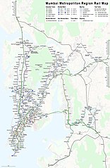
| 18:41, 14 September 2019 |  | 4,150 × 6,363 (11.61 MB) | Chumwa | {{Information |Description= *{{de|1=Linienplan der Vorortzüge, U-Bahnlinien und des sonstigen Schienenverkehrs in der Metropolregion Mumbai}} *{{en|Map of all the urban, suburban, and other rail-based services in the Mumbai metropolitan region}} |Author=Maximilian Dörrbecker (Chumwa) |Source={{own using}} OpenStreetMap data for the background |Date=see file history |Permission=All OpenStreetMap data and maps are Creative Commons "CC-BY-SA 2.0" l... |
File usage
The following page uses this file:
Global file usage
The following other wikis use this file:
- Usage on anp.wikipedia.org
- Usage on ar.wikipedia.org
- Usage on azb.wikipedia.org
- Usage on bn.wikipedia.org
- Usage on ca.wikipedia.org
- Usage on de.wikipedia.org
- Usage on de.wikivoyage.org
- Usage on en.wikipedia.org
- Usage on fi.wikipedia.org
- Usage on fr.wikipedia.org
- Usage on hi.wikipedia.org
- Usage on id.wikipedia.org
- Usage on it.wikipedia.org
- Usage on ja.wikipedia.org
- Usage on mr.wikipedia.org
- Usage on mt.wikipedia.org
- Usage on pl.wikipedia.org
- Usage on test.wikipedia.org
- Usage on uz.wikipedia.org
- Usage on www.wikidata.org
- Usage on zh.wikipedia.org